


FSX > Page 1786
33.71Mb (1363 downloads)
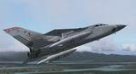
Alphasim RAF Tornado F3 1435 FLT Final Aircraft Textures only.
These textures depict the RAF Tornados of 1435 FLT Mount Pleasnat [Falklands], These are the final 4 Tornados on the flight before being replaced by the Typhoon in 1989.
Posted Aug 27, 2009 15:21 by ukmil
2.91Mb (4620 downloads)
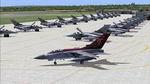
UKMIL AI Tornado F3
This pack inlcudes the Tornado F3 AI model as used by the UK RAF as a long range inteceptor
It comes with one texture of 56 sqn based at RAF LEUCHARS
To use these as AI you need to create some flightplans using many programs such as TTOOLS
Required files:
required file
Posted Aug 27, 2009 15:02 by ukmil
1.83Mb (4026 downloads)
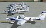
UKMIL AI Grob Tutor
This pack inlcudes the GROB TUTOR AI model as used by the UK TRAF as a trainer.
To use these as AI you need to create some flightplans using many programs such as TTOOLS
Required files:
required file
Posted Aug 27, 2009 14:59 by ukmil
1.71Mb (2511 downloads)
UKMIL AI VC-10 This is the multi lod, low poly AI VC10 made by UKMIL. it features multilods, and a working refuel probe system. the fuel booms will deploy when the aircraft gets over 5500ft, and will remain out until the aircraft descends below this alt. Although these are VISUALLY active, they do not have any FUNCTIONAL actions in Flight sim, they are for visual specs only to install, simply copy the folder called AI UKMIL VC10, found inside the AI AIRCRFT FILE folder, to either fs2004> AIRCRAFT folder FSX> SIMOBJECTS/AIRPLANES folder. You will need flighplans for this to work. you will be able to find some in the PLANS folder, or on the UKMIL WEBSITE ukmil
Posted Aug 27, 2009 14:56 by ukmil
11.33Mb (10440 downloads)
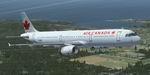
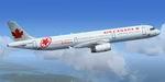
This pack includes 3 liveries: Boeing 737-800 Air Canada and Airbus A321 Air Canada and Air Canada Horizons. By RSvit
Posted Aug 27, 2009 13:19 by Rostyslav Svitelskiy
41.44Mb (2862 downloads)
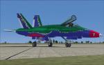
A Fictional Demonstration Team Textures for the FSX Acceleration F18.
Posted Aug 27, 2009 08:04 by Hotzoner

9.75Mb (4371 downloads)
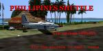
A FSX Mission for ship shape airline pilots out of a job. Fly with Olas Air, the newest Shuttle service in the Phillipines. Salary according to your experience and tact with passengers, specially women. You will be checked by Capt. Sireia Blanca, senior pilot of the company, she will really check you out. Important....clean nails are a must if you have any desire to fly these DH8's. Will need for mission...Dash 8-311 Regional airliner from Premaircraft.com "Five Aircraft Package-European" since Olas is part of Cirrus which is a partner of Lufthansa (Got it?)......file: dhc8_5ex.zip. Have a nice flight.
Required files:
required file
Posted Aug 26, 2009 17:38 by Gera Godoy Canova
3.73Mb (13068 downloads)
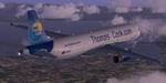
Airbus A321 Thomas Cook textures only for the default A321. By RSvit
Posted Aug 26, 2009 12:39 by RSvit
1.85Mb (1803 downloads)
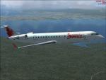
This is a repaint of the default bombardier crj-700 for fsx. I have repainted this In the textures of Jazz , Enjoy! Repaint By James Landes
fsx-repaints.com
Posted Aug 26, 2009 11:36 by James Landes
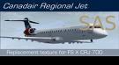
5.96Mb (3250 downloads)
CRJ 700 SAS Textures only for the default FSX CRJ-700. By Thomas Limmer
Posted Aug 26, 2009 07:07 by Thomas Limmer