


FSX > Page 1902
0.33Mb (2838 downloads)
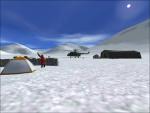
This package includes 4 base camps near K2 (K2B1, K2B2, K2B3 and K2B4). K2B1 (Pajyu Peak Base Camp) is the lowest camp (~3400m) on the end of the Baltoro Glacier in a wooden area with trees. It consists of one temporary small gravel runway with stone marks. K2B2 is the base camp on the Concordia Place (~4600m). Maybe you can approach with ski-airplanes on the snow field. K2B2 consists also of one temporary helipad. K2B2 is the biggest camp on the glacier. K2B3 is the base camp (~4960m) nearest the K2. It is build on an ice/gravel field and has one temporary gravel/ice runway with stone marks. It's too high for normal helicopters or ski-planes, but maybe possible. K2B4 is the Moonhill Camp (~5070m) on the way to the Gondogoro. It is not real possible to approach on the snow field.
In the internet you will find photo realistic scenery for the K2, Broad Peak and other mountains near the K2. Also use the additional airports "OPSD_Pakistan_K2.zip" and "VI57_Kashmir_K2.zip" to do a realistic flight to the K2.
Design by Bernhard W.
Posted Jan 9, 2009 08:02 by Bernhard W.
8.71Mb (11528 downloads)
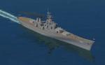
FEATURES:
- AI Version included for use with AICarriers2
- hardened deck
- Animated main guns (flaps key)
- custom gauge and 16' gun effects
- Crow's nest camera view
- Stable water dynamics / top speed in the low 30's
- custom wake effect
- night textures
*Tested using Acceleration and DX9 ;
compiled with the FSX SDK for FSX ONLY *By Bruce Fitzgerald
Posted Jan 9, 2009 07:01 by Bruce Fitzgerald
5.87Mb (12670 downloads)
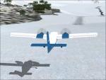
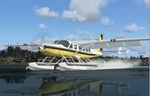
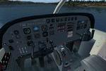
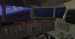
This is an update for FSX acceleration of the
Cessna 208 Caravan Amphibian from FS 9. I
have updated the flight dynamics, added a
trim gauge to the panel, changed the view
angle, added two float points, changed
everything necessary when I moved the datum
point from 13 feet to 0, and I aliased the
sound to the C208b. This is the whole
aircraft.
Bob Chicilo.
Posted Jan 9, 2009 06:50 by Bob Chicilo
94.68Mb (2579 downloads)
FS2004/FSX Arches National Park, Moab (KCNY), Utah (UT)Scenery. photo-scenery. This scenery covers another very beautiful National Park: Arches National Park near Moab in Utah. It contains the park itself, Moab, the La Sal Mountains and the northern part of Canyonlands National Park. The total area is 3.500 sq km and it comes in 4.7m/pix quality. By Gottfried Razek.
Posted Jan 8, 2009 15:08 by Gottfried Razek
22.85Mb (8980 downloads)
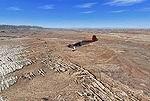
FSX and FS2004 Douglas C-74 Globemaster I
The C-74 was planned during World War 2 as a much bigger
successor to the C-54 Skymaster. An airliner version was
also planned, and PanAm actually ordered it as the 'DC-7'.
After the war it became obvious that a better design could
be made, so only 14 C-74 Globemasters were built. The
airliner version was cancelled, and the military version
was developed into the C-124 Globemaster II with a much
larger fuselage. Nevertheless, the C-74s gave good service
until retired in the mid 'fifties, a few of them continued
in use as commercial cargo transports.
By Jens B. Kristensen.
Posted Jan 8, 2009 14:28 by Jens B. Kristensen
18.99Mb (17639 downloads)
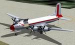
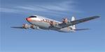
FSX Douglas DC-6 ver 2.0.
This package includes the DC-6 in its earliest form with short nose (no weather radar) and round-tipped Curtiss Electric propellers as delivered to the first DC-6 customers in 1946-48. The later aircraft had the more well-known, square-tipped 'paddle' propellers, and this version is included as well. Most, if not all, of the early DC-6's were later modernized to this standard, and many (especially from the U.S. operators) had weather radar installed in a longer nose. This package contains most variants, including liveries for American, United, Delta, Panagra, SAS, Sabena and KLM, nine aircraft in all. The KLM repaint is by Maarten Brouwer. Flight dynamics based on work by FSAviator. For FSX only; FS2004 users should get DC6_V20.zip instead.
By Jens B. Kristensen.
Posted Jan 8, 2009 14:02 by Jens B. Kristensen
0.13Mb (4679 downloads)
This update was designed with the latest version of ADE (v1.37) and made only for the FSX default airport my previous version not required: Terminal 5 now rebuilt for Jetblue, concourse C added at Terminal 8, includes a version with Crosswind rwy's operating, now activated by ADE where all 4 rwy's will be used for takeoff/landing and one as the default 2 rwy operation: assigned parking with extra parking, extra fuel trucks, support vehicle roads rebuilt and other minor improvements, airport views are from the roof of the control tower (when in tower view) please view the readme before installation
Posted Jan 8, 2009 13:42 by Ray Smith
0.24Mb (3938 downloads)
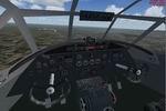
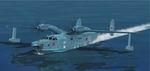
This is an update for FSX acceleration of the
Beriev Be-12 by V.Zhygulskiy. I have updated
the flight dynamics, changed the panel
background slightly, and changed gauges so
the panel would be usable in FSX. You need
the original aircraft for this update to work.
No virtual cockpit.
Bob Chicilo.
Required files:
required file
Posted Jan 8, 2009 12:37 by Bob Chicilo
9.07Mb (16580 downloads)
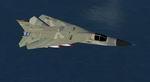
F-111 Aardvark in 494 Panthers and Night Attack liveries. Model adapted from the FS2004 F-111 by Mike Stone. Uses 2d F104 panel by Marco Spada. Textures by Mark Rooks. No virtual cockpit (No VC).
Posted Jan 8, 2009 07:30 by Uploader
1.34Mb (9793 downloads)
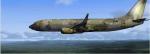
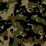
Boeing 737-800 woodland Camo Textures for the default 737. Textures by Mike Barton.
Posted Jan 7, 2009 19:10 by Mike Barton