


7.96Mb (2318 downloads)
'Clover' ground textures - represents the clovers I see on the ground of my camping vacation ;-)
Use it if you have a "big" computer.
Posted Aug 15, 2008 04:08 by Aimé Leclercq
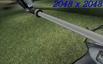
4.23Mb (11220 downloads)
Photoreal Grass Scenery for FSX. Created by Aimé Leclercq
Posted Aug 14, 2008 04:31 by Aimé Leclercq
0.02Mb (2872 downloads)
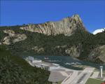
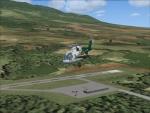
This is a fictional Airport Hidden in the Mountains of Glacier National Park Montana It is a update and rework of the earlier versions of Hidden Lake.
Posted Aug 12, 2008 21:21 by David Tokar
0.10Mb (3227 downloads)
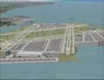
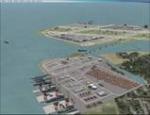
Fictional Chicago airport on the proposed site for airport expansion in the 1990s. On the site of the historic US Steel "South Works" plants, 600 acres of highly detailed airport. 4 intersecting runways, cargo area and marine port. Lots of little details added for fun. Explore the airport to view details. ILS freq appear in the map view.
Posted Aug 11, 2008 14:21 by Putt4Eagle
0.30Mb (3016 downloads)
This is a scenery update for Kapalua Airport on the island of Maui, Hawaii. Kapalua is a small airport located in the pineapple fields on Maui. Runways, taxiways, and parking were updated using real world coordinates from Google Earth. View Readme file for installation and notes. Compiled using Airport Design Editor.
Posted Aug 10, 2008 20:11 by Phillip Coyle
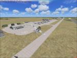
0.24Mb (2188 downloads)
This updates Sonoma County Airport for FSX. Taxiways, runways, and other aspects were updated using real satellite images from Google Earth for accuracy. This airport is home to some CDF Fire Tankers, and the taxiways leading up to their facility have been accuratly depicted in this release. Default objects from the FSX scenery libraries were used. View Readme file for installation instructions. Compiled using Airport Design Editor.
Posted Aug 10, 2008 12:06 by Phillip Coyle

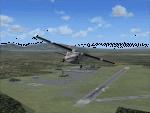
26.98Mb (1535 downloads)
Updated-new statics, Airport name is FSXF-Minot AFB (KMIB) added hangers, buildings, New starts(helo starts) etc... has static F-22S,, B-52S, A-225,, CHOOPERS,
Nuclear Power Plant Complex North Minot AFB. with two helo pads, or just find the Power Line Towers and follow them to it.
Added runway 11R/29L, added ILS, 11R-111.10 MHz, 29L-110.15 MHz, 11L-109.90 Mhz, 29R-109.30 MHZ, taxiways, etc...
Posted Aug 9, 2008 23:45 by Thunder
0.80Mb (869 downloads)
This is a Mission Scenery, the airport name is H3 Northwest(OR1L). It is in Iraq. No ILS. , updated stock airfield.
Tanks, S.A.M.s, around airfield. Temperary hangers, Crates in them, three static SU-37s on apron.
Posted Aug 9, 2008 23:08 by Thunder
26.98Mb (1549 downloads)
Updated-new statics, Airport name is FSXF-Minot AFB (KMIB) added hangers, buildings, New starts(helo starts) etc... has static F-22S,, B-52S, A-225,, CHOOPERS, rn Nuclear Power Plant Complex North Minot AFB. with two helo pads, or just find the Power Line Towers and follow them to it.rn Added runway 11R/29L, added ILS, 11R-111.10 MHz, 29L-110.15 MHz, 11L-109.90 Mhz, 29R-109.30 MHZ, taxiways, etc...
Posted Aug 9, 2008 04:27 by Thunder

0.01Mb (1957 downloads)
Creation of the flying club at Berriel in Grand Canaria, Spain.
Posted Aug 7, 2008 12:28 by archive