


FSX > Page 1192
16.03Mb (674 downloads)
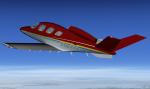
Repaint of the payware FlightSim Developers Cirrus
Jet; added color to the pinstripes on the
sides of the fuselage. Repaint by Rick Federmann (Pville211)
Posted Nov 11, 2012 15:55 by Pville211
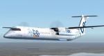
28.40Mb (9075 downloads)
Dreamwings's magnificent Dash 8-Q400 in Flybe livery in 7 variations of Flybe's Dash-8s. Textures by Billy Rutherford. Uses the default Lear 45 2d panel. No VC.
Posted Nov 11, 2012 10:43 by RyanID
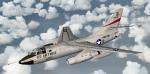
7.58Mb (4491 downloads)
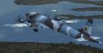
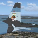
The Douglas B-66 was originally designed to replace the A-26 as a light bomber. The first flight was in 1954 and 294 aircrafts were built. Credits: Virtavia for the original model. Adaptation to FSX, VC and wide screen panel including GPWS callout by Philippe Wallaert. See instructions for installation in the readme.txt file. Nice Flights!
Posted Nov 11, 2012 07:31 by Philippe Wallaert
33.07Mb (6608 downloads)
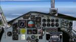
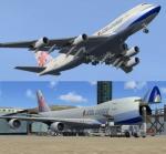
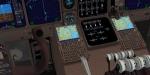
SkySpirit 2011 Boeing 747-400SCF China Airlines Cargo FSX with advanced VC
Assembled and edited for FSX with default B7474 VC, by Chris Evans. Thank you to Skyspirit for their wonderful models. Beautiful China Airlines Cargo repaint by Mathieu Vos. With Enhanced VC from Alejandro Rojas Lucenda.
Skyspirit FSX native Boeing 747-400 model upgraded using the vastly improved Boeing 747 VC from Alejandro Rojas Lucena/FSND (See panel docs for details). VC includes FMC, EICAS, MFD with control panel, GPWS, working wipers, cabin lights, fire suppression, avionics switch, fuel crossfeed, landing lights switches, taxi light switch, engine generators, APU generator, battery switch, starter switches, de-ice switch, general lights switches. Beautiful Skyspirit 747-400 cargo model with complex features and ground service vehicles (press shift e 2, shift e 3, etc. ). To use jetway press Ctrl J.
Also includes the Boeing 747 VC textures upgrade. This gives a much clearer 747 interior virtual cockpit look.
Assembled and edited for FSX by Chris Evans.
Zip preview for larger pictures.
See panel docs and images for VC details and controls
Posted Nov 11, 2012 06:15 by Chris Evans
1.30Mb (723 downloads)
FSX/FS9 texture update for my Ilyushin-38 addon (IL38-camo.zip). The russian 4-engine sea Patrol and anti submarine airplane Ilyushin- 38 is based on the very reliable IL-18 passenger airplane and was exported to India. My update is in fictional camo-scheme for Indian Navy and replaces only few textures from my russion version. The original flight model is made by makc-sims. Bitmaps by Erwin Welker.
Required files:
required file
Posted Nov 11, 2012 05:24 by Erwin Welker
0.18Mb (1292 downloads)
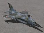
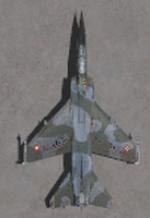
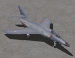
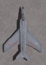
This package contains 2 sets of camera views ( defined by camera definitions in the aircraft.cfg file ) for
the beautiful Dassault Mirage F1 model by Kirk Olsson ( Gmax Mirage F1 package V2 ).
Updated for FSX by Danny Garnier. Some gauges by Romain Lucas and Laurent Lucas borrowed from
the Dassault Super Etendard.
Version 1.0 - Cameras are located at about the same level of the aircraft.
Version 2.0 - based on version 1.0 but some of the cameras are placed at a higher level.
10 cameras pointing at the aircraft - including a new "Top-down" zoomable view.
Total of 3 VC cams including 2 new "Over the shoulder" views.
See Read me.txt file for very easy installation procedures.
Camera definitions sets are included in 2 separate text files.
Available.pdf and Top 20.pdf for informations about my "camera definitions" packages.
Required files:
required file
Posted Nov 10, 2012 15:59 by Marc Renaud
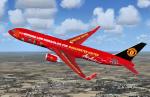
2.33Mb (359 downloads)
Asian Air Manchester United textures for the payware Level D Boeing 767-300.
This is my version of the Asian Air Manchester United the Boeing 767-300 Winglet.
You need the Level D-767 Winglet.
Textures by Peter Franeker.
Posted Nov 10, 2012 06:15 by Peter Franeker
4.06Mb (5915 downloads)
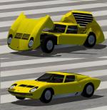
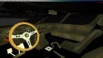
FSX Lamborghini Miura. Since it is a car and not an airplane, don't expect it to be able to fly at all. It has VC and gauges. The Speedometer is in metric. by Harri Thaha & Hadi Tahir
Posted Nov 10, 2012 03:16 by Hadi Tahir
0.24Mb (581 downloads)
This package contains 2 sets of camera views ( defined by camera definitions in the aircraft.cfg file ) for the beautiful Dassault Mirage F1 model by Kirk Olsson ( Gmax Mirage F1 package V2 ). Updated for FSX by Danny Garnier. Some gauges by Romain Lucas and Laurent Lucas borrowed from the Dassault Super Etendard. Version 1.0 - Cameras are located at about the same level of the aircraft. Version 2.0 - based on version 1.0 but some of the cameras are placed at a higher level. 10 cameras pointing at the aircraft - including a new Top-down zoomable view. Total of 3 VC cams including 2 new Over the shoulder views. See Read me.txt file for very easy installation procedures. Camera definitions sets are included in 2 separate text files. Available.pdf and Top 20.pdf for informations about my camera definitions packages.
Required files:
required file
Posted Nov 9, 2012 23:47 by Marc Renaud
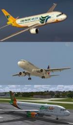
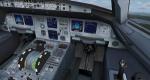
57.32Mb (5105 downloads)
Philippines A320 3 Airlines Package with Updated VC. Includes Philippines, Cebu and Zest airlines liveries and a vc and panel updated to include GPWS and more. Original model by Project Airbus.
Posted Nov 9, 2012 21:19 by Matthew