


FSX > Page 1232
32.70Mb (7090 downloads)
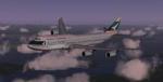
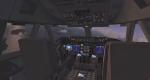
SkySpirit 2011 - Cathay Pacific Boeing 747-8i Skyspirit FSX native Boeing 747-800 Freighter model upgraded using the vastly improved Boeing 747 VC from Alejandro Rojas Lucena/FSND (See panel docs for details). VC includes FMC, EICAS, MFD with control panel, GPWS, working wipers, cabin lights, fire suppression, avionics switch, fuel crossfeed, landing lights switches, taxi light switch, engine generators, APU generator, battery switch, starter switches, de-ice switch, general lights switches. Beautiful Skyspirit 747-800 Freighter model with complex features and ground service vehicles (press shift e 2, shift e 3, etc. ). Textures by Project Opensky member. Also includes Boeing 747 VC textures upgrade by Jason A. Lee. This give a much clearer 747 interior look. Assembled and edited for FSX by Chris Evans. Zip preview for larger pictures. See panel docs and images for VC details and controls!
Posted Aug 10, 2012 17:11 by chris evans

7.14Mb (904 downloads)
For FSX with DX9 only! XY-AGG, XY-AGI, XY-AGL and XY-AGM. With new Myanmar (Burma) flag, that is used in the country since October 2010. You need the base-pack mai322x.zip
Required files:
required file
Posted Aug 10, 2012 15:20 by HOUSE-RP, Robby Pauletto
2.70Mb (301 downloads)
This is an Addon for Orbix Jefferson County International airport (0S9) and Orbix PNW scenery packages. The three .BGL files include: -Downtown city of Port Townsend, WA -Washington State Ferrie Docks with cars waiting to load -Industrial area representing PT Paper Mill -Two city of Port Townsend Marinas -US Coast Gaurd station -Point Wilson lighthouse with rotating beacon (complete with night textures)
Posted Aug 9, 2012 14:35 by Larry Robbins
2.36Mb (2067 downloads)
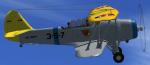
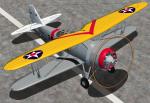
The SBU-1 first entered service in 1935. It was the first scout bomber to exceed 200 mph and the first US Navy plane to use cowl flaps for better engine cooling. This is a native FSX Acceleration model. It features the usual animations plus cowl flaps. It has a specular shine and liveries for service on the US CV-2, CV-3 and CV-4 carriers. The VC is based on real photos. It has animated flight controls and back lighted gauges for night operations. By Paul Clawson
Posted Aug 9, 2012 03:40 by Paul Clawson
63.26Mb (650 downloads)
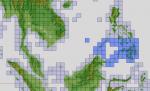
"imp" means imperfect, as other mesh I have already processed is of areas that have very little vegetation cover - over the land, or has large urban areas.
This "imp" mesh will include some slight discrepancies of altitude (in the case of forested areas - by a magnitude sometimes of +15 metres-depending on how tall the trees are, in the jungle or forest canopy) over urban areas, or areas with a lot of vegetation cover - due to the limitations of the ASTER satellites infra red scanning cameras, and the software used to process the DEM data.
Areas where there is little vegetation cover, or non urban areas, the terrain should have truer values.
But I feel this ASTER DEM data is so good - why let it all go to waste - especially flying over lovely Pacific islands?
So you FSX users out there will have to take all this into account when using this mesh.
Grateful thanks to ERSDAC, and NASA for making this data freely available to the public.
ASTER GDEM
Copyright (c) 2009 - 2011 Earth Remote Sensing Data Analysis Center (ERSDAC) All rights reserved.
ASTER GDEM is a product of METI and NASA.
Posted Aug 9, 2012 02:37 by Wayne Evans
72.18Mb (821 downloads)
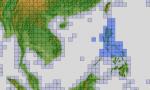
"imp" means imperfect, as other mesh I have already processed is of areas that have very little vegetation cover - over the land, or has large urban areas.
This "imp" mesh will include some slight discrepancies of altitude (in the case of forested areas - by a magnitude sometimes of +15 metres-depending on how tall the trees are, in the jungle or forest canopy) over urban areas, or areas with a lot of vegetation cover - due to the limitations of the ASTER satellites infra red scanning cameras, and the software used to process the DEM data.
Areas where there is little vegetation cover, or non urban areas, the terrain should have truer values.
But I feel this ASTER DEM data is so good - why let it all go to waste - especially flying over lovely Pacific islands?
So you FSX users out there will have to take all this into account when using this mesh.
Grateful thanks to ERSDAC, and NASA for making this data freely available to the public.
ASTER GDEM
Copyright (c) 2009 - 2011 Earth Remote Sensing Data Analysis Center (ERSDAC) All rights reserved.
ASTER GDEM is a product of METI and NASA.
Posted Aug 9, 2012 02:16 by Wayne Evans
0.00Mb (601 downloads)
FSX Scenery (FSX Only)
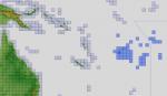
Africa - Tanzania - V-shaped trench correction to the default FSX area.
This is a self-contained scenery and it does not alter any of FSX's native files.
At location lat -6.74 lon +34.05, in Tanzania, Africa, there is a huge V-shaped trench that is obviously not natural and couldn't possibly real and be man-made. Each leg of the V is over a hundred kilometres long and one thousand metres deep.
This scenery "anomaly" appears in FS2004 as well, but in FS2004 it is made in a different way. In FSX the trench is formed by a narrow, long, V-shaped airport grass background. I removed it by removing the airport background. [G. identified it as an airport background (FS Developer forum)]
For free distribution only.
By Fern Marques
fernmarques@yahoo.com
Posted Aug 8, 2012 12:37 by Fern Marques
12.87Mb (659 downloads)
"imp" means imperfect, as other mesh I have already processed is of areas that have very little vegetation cover - over the land, or has large urban areas.
This "imp" mesh will include some slight discrepancies of altitude (in the case of forested areas - by a magnitude sometimes of +15 metres-depending on how tall the trees are, in the jungle or forest canopy) over urban areas, or areas with a lot of vegetation cover - due to the limitations of the ASTER satellites infra red scanning cameras, and the software used to process the DEM data.
Areas where there is little vegetation cover, or non urban areas, the terrain should have truer values.
But I feel this ASTER DEM data is so good - why let it all go to waste - especially flying over lovely Pacific islands?
So you FSX users out there will have to take all this into account when using this mesh.
Grateful thanks to ERSDAC, and NASA for making this data freely available to the public.
ASTER GDEM
Copyright (c) 2009 - 2011 Earth Remote Sensing Data Analysis Center (ERSDAC) All rights reserved.
ASTER GDEM is a product of METI and NASA.
Posted Aug 8, 2012 09:47 by Wayne Evans


219.35Mb (24620 downloads)
This Airbus A380 Multi-Livery Mega-Package contains the A380 Model created by The Project Airbus Team and Virtual Cockpit of the A340 family created by Thomas Ruth, 18 High-Quality Liveries, custom soundset for the Rolls-Royce Trent 800 engines created by Emil Serafino (who gave me his permission to use his soundsets), a fully edited aircraft.cfg with 27 custom-made views and jetway & cargo-truck codes included, gauges for the Flight Management Computer (FMC), Ground Proximity Warning System (GPWS) and AutoBrake systems created by dfferent authors and a lot of dedication. For a detailed explanation in English & Spanish, a list of liveries and some pictures, visit my blog at: http://fsxluchoals.blogspot.com/
Posted Aug 7, 2012 22:45 by Luis Quintero

2.91Mb (1804 downloads)
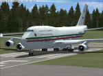
FSX Boeing 747-400 Mexico Air Force TP-01 textures only for the default 747. TP-01 is the Mexico Presidential aircraft. I know that they have the B757 in use , but this repaint was specially requested. Repaint by Enrique Cornejo. 2MB
Posted Aug 7, 2012 20:34 by Enrique Cornejo