


FSX > Page 1237

0.10Mb (1604 downloads)
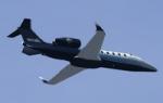
Views ( defined by camera definitions in the aircraft.cfg file ) for
the beautiful ( Bombardier ) Learjet 60 by Premier Aircraft Design.
8 cameras pointing at the aircraft and 6 additional cameras inside.
See Read me.txt file for very easy installation procedures.
Also included is a text file that contains the new camera definitions.
Enjoy !
Required files:
required file
Posted Jul 28, 2012 16:24 by Marc Renaud

31.81Mb (13775 downloads)
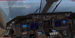
Boeing 747-400 British Airways Passenger Package for FSX
Skyspirit FSX native Boeing 747-400 model upgraded using the vastly
improved Boeing 747 VC from Alejandro Rojas Lucena/FSND (See panel
docs for details). VC includes FMC, EICAS, MFD with control panel,
GPWS, working wipers, cabin lights, fire suppression, avionics
switch, fuel crossfeed, landing lights switches, taxi light switch,
engine generators, APU generator, battery switch, starter switches,
de-ice switch, general lights switches. Beautiful Skyspirit 747
model with complex features and ground service vehicles (press shift
e 2, shift e 3, etc. Press Ctrl J for Jetway). Professional BA
textures by RyanC.
Also includes Boeing 747 VC textures upgrade by Jason A. Lee. This
give a much clearer 747 interior look.
Assembled and edited for FSX by Chris Evans.
Posted Jul 28, 2012 09:38 by archive

2.76Mb (3453 downloads)
Welcome to the Bahamas!!!Grand Bahama International Airport is the main gateway to Freeport Bahamas. Located in the northern tip of the Bahamas, Freeport is the nations second capital. Created by BahamasFlyers....Enjoy
Posted Jul 28, 2012 01:40 by Shawn Penn
3.50Mb (759 downloads)
For use with turboprop aircraft that have been outfitted with the default Bombardier CRJ virtual cockpit. Contains a mix of default and 3rd party gauges. Enjoy
Posted Jul 28, 2012 01:33 by Skilaeb Dygsbi

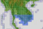
81.36Mb (835 downloads)
"imp" means imperfect, as other mesh I have already processed is of areas that have very little vegetation cover - over the land, or has large urban areas.
This "imp" mesh will include some slight discrepancies of altitude (in the case of forested areas - by a magnitude sometimes of +15 metres-depending on how tall the trees are, in the jungle or forest canopy) over urban areas, or areas with a lot of vegetation cover - due to the limitations of the ASTER satellites infra red scanning cameras, and the software used to process the DEM data.
Areas where there is little vegetation cover, or non urban areas, the terrain should have truer values.
But I feel this ASTER DEM data is so good - why let it all go to waste - especially flying over lovely Pacific islands?
So you FSX users out there will have to take all this into account when using this mesh.
Grateful thanks to ERSDAC, and NASA for making this data freely available to the public.
ASTER GDEM
Copyright (c) 2009 - 2011 Earth Remote Sensing Data Analysis Center (ERSDAC) All rights reserved.
ASTER GDEM is a product of METI and NASA.
Posted Jul 28, 2012 01:31 by Wayne Evans

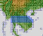
19.65Mb (5913 downloads)
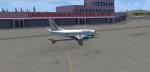
DHC-6 Paradise Island Airlines operated out of Paradise Island, Bahamas home of Atlantis. The Twin Otter was for Business Purposes more than for Commercial use. Model with VC by Premier Aircraft Design. Painted by BahamasFlyers.
Posted Jul 28, 2012 01:08 by Shawn Penn
48.99Mb (760 downloads)
"imp" means imperfect, as other mesh I have already processed is of areas that have very little vegetation cover - over the land, or has large urban areas.
This "imp" mesh will include some slight discrepancies of altitude (in the case of forested areas - by a magnitude sometimes of +15 metres-depending on how tall the trees are, in the jungle or forest canopy) over urban areas, or areas with a lot of vegetation cover - due to the limitations of the ASTER satellites infra red scanning cameras, and the software used to process the DEM data.
Areas where there is little vegetation cover, or non urban areas, the terrain should have truer values.
But I feel this ASTER DEM data is so good - why let it all go to waste - especially flying over lovely Pacific islands?
So you FSX users out there will have to take all this into account when using this mesh.
Grateful thanks to ERSDAC, and NASA for making this data freely available to the public.
ASTER GDEM
Copyright (c) 2009 - 2011 Earth Remote Sensing Data Analysis Center (ERSDAC) All rights reserved.
ASTER GDEM is a product of METI and NASA.
Posted Jul 28, 2012 00:55 by Wayne Evans
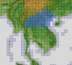
101.52Mb (757 downloads)
"imp" means imperfect, as other mesh I have already processed is of areas that have very little vegetation cover - over the land, or has large urban areas.
This "imp" mesh will include some slight discrepancies of altitude (in the case of forested areas - by a magnitude sometimes of +15 metres-depending on how tall the trees are, in the jungle or forest canopy) over urban areas, or areas with a lot of vegetation cover - due to the limitations of the ASTER satellites infra red scanning cameras, and the software used to process the DEM data.
Areas where there is little vegetation cover, or non urban areas, the terrain should have truer values.
But I feel this ASTER DEM data is so good - why let it all go to waste - especially flying over lovely Pacific islands?
So you FSX users out there will have to take all this into account when using this mesh.
Grateful thanks to ERSDAC, and NASA for making this data freely available to the public.
ASTER GDEM
Copyright (c) 2009 - 2011 Earth Remote Sensing Data Analysis Center (ERSDAC) All rights reserved.
ASTER GDEM is a product of METI and NASA.
Posted Jul 27, 2012 23:26 by Wayne Evans

101.37Mb (723 downloads)
"imp" means imperfect, as other mesh I have already processed is of areas that have very little vegetation cover - over the land, or has large urban areas.
This "imp" mesh will include some slight discrepancies of altitude (in the case of forested areas - by a magnitude sometimes of +15 metres-depending on how tall the trees are, in the jungle or forest canopy) over urban areas, or areas with a lot of vegetation cover - due to the limitations of the ASTER satellites infra red scanning cameras, and the software used to process the DEM data.
Areas where there is little vegetation cover, or non urban areas, the terrain should have truer values.
But I feel this ASTER DEM data is so good - why let it all go to waste - especially flying over lovely Pacific islands?
So you FSX users out there will have to take all this into account when using this mesh.
Grateful thanks to ERSDAC, and NASA for making this data freely available to the public.
ASTER GDEM
Copyright (c) 2009 - 2011 Earth Remote Sensing Data Analysis Center (ERSDAC) All rights reserved.
ASTER GDEM is a product of METI and NASA.
Posted Jul 27, 2012 23:04 by Wayne Evans
101.03Mb (761 downloads)
"imp" means imperfect, as other mesh I have already processed is of areas that have very little vegetation cover - over the land, or has large urban areas.
This "imp" mesh will include some slight discrepancies of altitude (in the case of forested areas - by a magnitude sometimes of +15 metres-depending on how tall the trees are, in the jungle or forest canopy) over urban areas, or areas with a lot of vegetation cover - due to the limitations of the ASTER satellites infra red scanning cameras, and the software used to process the DEM data.
Areas where there is little vegetation cover, or non urban areas, the terrain should have truer values.
But I feel this ASTER DEM data is so good - why let it all go to waste - especially flying over lovely Pacific islands?
So you FSX users out there will have to take all this into account when using this mesh.
Grateful thanks to ERSDAC, and NASA for making this data freely available to the public.
ASTER GDEM
Copyright (c) 2009 - 2011 Earth Remote Sensing Data Analysis Center (ERSDAC) All rights reserved.
ASTER GDEM is a product of METI and NASA.
Posted Jul 27, 2012 22:02 by Wayne Evans