


FSX > Page 1247
10.02Mb (1846 downloads)
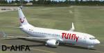
TUIfly D-AHFA Textures for the default
Boeing 737-800 FSX
Posted Jul 10, 2012 06:31 by Jim Fly
1.72Mb (3051 downloads)
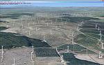
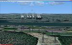
Includes all v4.0 scenery add-ons previously available at Simviation.com
Minor improvements to model library.
Adds 1,000+ wind turbines, mostly in UK & New Zealand. (Now 11,000+ turbines world-wide) including Whitelee wind farm, Scotland (2nd largest on-shore wind farm in Europe).
FSXPP scenery objects in England, Wales & South Scotland aligned to Horizon GenerationX photo scenery -
volumes 1, 2, 3 & 8. Approx' 39,000 electricity pylons mostly aligned to photo scenery.
Exclude file to remove additional 'clone' of the Falkirk Wheel scenery object when using GenerationX photo scenery with Ultimate TerrainX Europe scenery enabled.
Whitelee wind farm & Grangemouth power station pictured - both Scotland South.
Posted Jul 9, 2012 17:03 by Ray Porter
18.08Mb (1013 downloads)
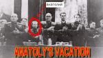
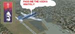
Each soviet citizen could take a vacation for 22 and more working days.Some groups like the military, doctors, etc would take one for 30 or 40 days. People would go to the sanatorium in their region, they could go to Crimea, to the Caucasus, Bulgaria and sometimes to other Eastern Countries of Europe - A boom place was SOCHI. To the Russians the equivalent of the Mediterranean Coast with palm trees, hotels, large beaches, hot weather, Vodka and women. You can join the IL-14 crew and take a batch of comarades to this sunny paradise spend the night there and return to Moscow tomorrow...Stalin was here once, never came back again.
Posted Jul 9, 2012 11:19 by Gera Godoy Canova
140.97Mb (10484 downloads)
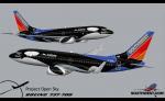
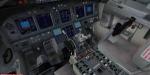
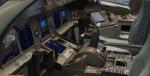
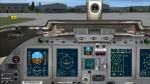
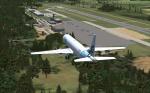
Boeing 737-700 Southwest Airlines Liveries Package with revised VC. A package of 737-700s painted in various Southwest Airlines liveries, including "Tribute to the Tuskegee Airmen" (Canyon Blue), "Retired Desert Livery," "New Mexico One," "Slam Dunk One," "Maryland One," "Nevada One," "Shamu," "AirTran," and the Boeing House livery. Thanks to the POSKY team for models and paints. The aircraft includes a custom sound set. Also included now the revised VC by Alejandro Rojas Lucena including EICAS, GPWS (ground call outs), working wipers, APU, FMC and more! Native FSX model by Project Opensky.
Posted Jul 9, 2012 05:47 by Russell Irwin
55.44Mb (10163 downloads)
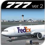
FedEx Boeing 777-200 Package with added tail view. Includes Posky FSX compatible VC by edited Danny Garnier and other FSX updates by Chris Evans. Custom Boeing 777 sounds included. Includes inbuilt-scenery loaders and pushback tug: Opening Passenger (L1) door: Shift + E ( Opening door ) Opening Cargo Doors: Shift + E + 2 Opening Passenger (L2) door: Shift + E + 3 Opening Bulk Cargo Door: Shift + E + 4 Model by Project Opensky.
Posted Jul 8, 2012 09:43 by Peter D
61.41Mb (5936 downloads)
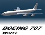
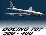
Boeing 707-200 Mega Package with added tail views - This is the Guzman Arts wonderful Boeing 707 collection with added tail views. (If you already have the original pack this only adds tails views) Model by Libardo Guzman.
Posted Jul 8, 2012 09:19 by Peter D
4.34Mb (4965 downloads)
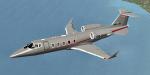
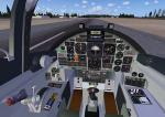
Bombardier Learjet 60 XR in Vistajet livery. This very popular aircraft is an extension of the Learjet 60 with some improvements and a new avionic. More than 400 units have been built. Credits: PAD for the original model. Vistajet textures and 2D wide screen panel by Philippe Wallaert (no VC). See instructions in the readme.txt files. Nice flights!
Posted Jul 8, 2012 07:20 by Philippe Wallaert
1.94Mb (4464 downloads)
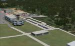
Aix-les-Bains airport is situated on the edge of a lake near Lyon and Geneva.
It is mainly used in the Winter months during the ski season. The biggest plane that lands there is the 757.
I have used sallite images as a template for design this beautiful airport and the buildings are in the accurate places but uses the fsx library buildings because i'm about as artistic as a rock.
There are accurate roads around the airport so driving is possible for those how want to.
Happy Flying :)
Total time spent: 16 hours and a lot of coffee
Posted Jul 7, 2012 06:28 by JW
15.96Mb (13894 downloads)
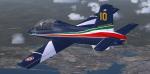
This model is a complete rework of the original MB-339A PAN (Pattuglia Acrobatica Nazionale) released some years ago with an improved visual model, and virtual cockpit. This new version of the model contains textures for a standard example of "Frecce Tricolori", the acrobatic military Italian team, with added 10 different fuselage textures to choose from to make a personalized tail code example in the team.
Visual Model, textures and revised Flight Dynamics by Massimo Taccoli.
Original panel and Gauges by Paolo Zamparo,
Sound files with permission of Aaron R. Swindle.
Posted Jul 6, 2012 05:53 by massimo Taccoli
12.86Mb (2075 downloads)
This is not a Mission!!!...A first time in FSX it is!!!!!. First you will Listen to instructions, then you will --Read a Short Story about the Adventure Max Rex got into by following a beautiful woman in an expedition to Burma back in the 1930s.--In it you will find the routes they took and you get a map to plot them--then and only then will you find the mysterious Temples and the final outcome of the expedition....I hope you enjoy the story and the flights...For experienced bush pilots only.
Posted Jul 5, 2012 23:27 by Gera Godoy Canova