


FSX > Page 1274
26.85Mb (3175 downloads)
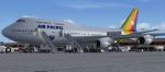
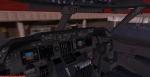
Air Pacific B747-412 v4 for FSX. Air Pacific Limited is the flag carrier airline of Fiji. It operates international and domestic services around the Pacific and to North America and Hong Kong
Features recolored default 747 VC, Ground services. Posky utilities to enable ground
service traffic and stairs. (Find it under Views-Instrument panel - Posky Utilities).
Textures by Xudeva Irribarra. Upgraded to FSX model by Chris Evans.
Posted May 17, 2012 18:01 by Chris Evans
166.80Mb (329 downloads)
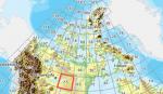
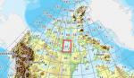
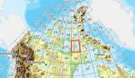
As Raimondo Taburet hasn't processed the CDED files above 60 degrees latitude for Canada, well here are the ones I have processed.
There isn't any data available from geobase in some of the blocks above 60 degrees latitude, these are blocks: 15, 17, 18, 28, 108, 109, 118, 119.
See jpg for coverage.
Thanks go to Geobase (Copyright) Canada for the availability & public use of this data.
Posted May 17, 2012 13:24 by Wayne Evans
45.92Mb (277 downloads)
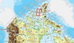
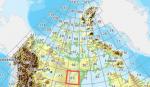
As Raimondo Taburet hasn't processed the CDED files above 60 degrees latitude for Canada, well here are the ones I have processed.
There isn't any data available from geobase in some of the blocks above 60 degrees latitude, these are blocks: 15, 17, 18, 28, 108, 109, 118, 119.
See jpg for coverage.
Thanks go to Geobase (Copyright) Canada for the availability & public use of this data.
Posted May 17, 2012 12:37 by Wayne Evans

62.17Mb (241 downloads)
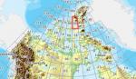
As Raimondo Taburet hasn't processed the CDED files above 60 degrees latitude for Canada, well here are the ones I have processed.
There isn't any data available from geobase in some of the blocks above 60 degrees latitude, these are blocks: 15, 17, 18, 28, 108, 109, 118, 119.
See jpg for coverage.
Thanks go to Geobase (Copyright) Canada for the availability & public use of this data.
Posted May 17, 2012 12:19 by Wayne Evans
36.12Mb (269 downloads)
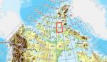
As Raimondo Taburet hasn't processed the CDED files above 60 degrees latitude for Canada, well here are the ones I have processed.
There isn't any data available from geobase in some of the blocks above 60 degrees latitude, these are blocks: 15, 17, 18, 28, 108, 109, 118, 119.
See jpg for coverage.
Thanks go to Geobase (Copyright) Canada for the availability & public use of this data.
Posted May 17, 2012 11:48 by Wayne Evans

127.61Mb (274 downloads)
As Raimondo Taburet hasn't processed the CDED files above 60 degrees latitude for Canada, well here are the ones I have processed.
There isn't any data available from geobase in some of the blocks above 60 degrees latitude, these are blocks: 15, 17, 18, 28, 108, 109, 118, 119.
See jpg for coverage.
Thanks go to Geobase (Copyright) Canada for the availability & public use of this data.
Posted May 17, 2012 11:37 by Wayne Evans
126.63Mb (299 downloads)
As Raimondo Taburet hasn't processed the CDED files above 60 degrees latitude for Canada, well here are the ones I have processed.
There isn't any data available from geobase in some of the blocks above 60 degrees latitude, these are blocks: 15, 17, 18, 28, 108, 109, 118, 119.
See jpg for coverage.
Thanks go to Geobase (Copyright) Canada for the availability & public use of this data.
Posted May 17, 2012 11:07 by Wayne Evans
112.11Mb (267 downloads)
As Raimondo Taburet hasn't processed the CDED files above 60 degrees latitude for Canada, well here are the ones I have processed.
There isn't any data available from geobase in some of the blocks above 60 degrees latitude, these are blocks: 15, 17, 18, 28, 108, 109, 118, 119.
See jpg for coverage.
Thanks go to Geobase (Copyright) Canada for the availability & public use of this data.
Posted May 17, 2012 10:42 by Wayne Evans
81.56Mb (246 downloads)
As Raimondo Taburet hasn't processed the CDED files above 60 degrees latitude for Canada, well here are the ones I have processed.
There isn't any data available from geobase in some of the blocks above 60 degrees latitude, these are blocks: 15, 17, 18, 28, 108, 109, 118, 119.
See jpg for coverage.
Thanks go to Geobase (Copyright) Canada for the availability & public use of this data.
Posted May 17, 2012 10:21 by Wayne Evans
86.20Mb (253 downloads)
As Raimondo Taburet hasn't processed the CDED files above 60 degrees latitude for Canada, well here are the ones I have processed.
There isn't any data available from geobase in some of the blocks above 60 degrees latitude, these are blocks: 15, 17, 18, 28, 108, 109, 118, 119.
See jpg for coverage.
Thanks go to Geobase (Copyright) Canada for the availability & public use of this data.
Posted May 17, 2012 09:59 by Wayne Evans