


FSX > Page 1807

48.24Mb (1911 downloads)
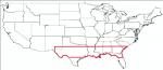
USA South East USGS 10 metre mesh terrain - FSX only.
This constitutes 10 metre terrain mesh for a section of the USA, The whole USA East mesh files will abutt the US West Coast 10m mesh already available, that was made by: Raimondo Taburet. Make sure you have your scenery terrain settings at about 5 metres in the FSX display dialogue for the mesh to show properly! Includes: NM, TX, LA, MS, AL, FL, GA, SC.
Posted Jul 20, 2009 11:02 by Wayne Evans
25.98Mb (1972 downloads)
USA South East USGS 10 metre mesh terrain - FSX only.
This constitutes 10 metre terrain mesh for a section of the USA, The whole USA East mesh files will abutt the US West Coast 10m mesh already available, that was made by: Raimondo Taburet. Make sure you have your scenery terrain settings at about 5 metres in the FSX display dialogue for the mesh to show properly! Includes: NM, TX, LA, MS, AL, FL, GA, SC.
Posted Jul 20, 2009 10:26 by Wayne Evans
19.39Mb (21451 downloads)
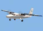
FSX Viking DHC6-400 Twin Otter.
The worldwide demand for refurbished Twin Otters is such that
Viking Air have commenced manufacture of new aircraft
in their plant in Calgary, Canada, using original de Havilland
jigs and tools. The new manufacture -400 model is externally
identical to the -300 but has a Honeywell "glass cockpit" avionics suite. We could not source freeware Honeywell gauges so we have used Garmin avionics in this model. The launch customer is Zimex
Aviation of Switzerland and first delivery is expected in
September 2009. Full package for FSX/SP2 (DX9 graphics) with five liveries, including authentic Zimex Aviation livery.
By Jean-Pierre Brisard, Barry Blaisdell, Kevin Pardy,
& Bob May - Premier Aircraft Design.
Posted Jul 20, 2009 09:03 by bob.may@premaircraft.com

58.60Mb (2125 downloads)
USA South East USGS 10 metre mesh terrain - FSX only.
This constitutes 10 metre terrain mesh for a section of the USA, The whole USA East mesh files will abutt the US West Coast 10m mesh already available, that was made by: Raimondo Taburet. Make sure you have your scenery terrain settings at about 5 metres in the FSX display dialogue for the mesh to show properly! Includes: NM, TX, LA, MS, AL, FL, GA, SC.
Posted Jul 20, 2009 08:46 by Wayne Evans

46.30Mb (2056 downloads)
USA South East USGS 10 metre mesh terrain - FSX only.
This constitutes 10 metre terrain mesh for a section of the USA, The whole USA East mesh files will abutt the US West Coast 10m mesh already available, that was made by: Raimondo Taburet. Make sure you have your scenery terrain settings at about 5 metres in the FSX display dialogue for the mesh to show properly! Includes: NM, TX, LA, MS, AL, FL, GA, SC.
Posted Jul 20, 2009 08:09 by Wayne Evans

60.62Mb (2230 downloads)
USA South East USGS 10 metre mesh terrain - FSX only.
This constitutes 10 metre terrain mesh for a section of the USA, The whole USA East mesh files will abutt the US West Coast 10m mesh already available, that was made by: Raimondo Taburet. Make sure you have your scenery terrain settings at about 5 metres in the FSX display dialogue for the mesh to show properly! Includes: NM, TX, LA, MS, AL, FL, GA, SC.
Posted Jul 20, 2009 07:38 by Wayne Evans

53.88Mb (2328 downloads)
USA South East USGS 10 metre mesh terrain - FSX only.
This constitutes 10 metre terrain mesh for a section of the USA, The whole USA East mesh files will abutt the US West Coast 10m mesh already available, that was made by: Raimondo Taburet. Make sure you have your scenery terrain settings at about 5 metres in the FSX display dialogue for the mesh to show properly! Includes: NM, TX, LA, MS, AL, FL, GA, SC.
Posted Jul 20, 2009 06:57 by Wayne Evans
0.54Mb (1722 downloads)
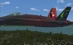
Updated Night Ops Textures for the FSX Acceleration F18.
Posted Jul 19, 2009 17:35 by Jason Aldrich
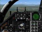
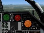
15.88Mb (1209 downloads)
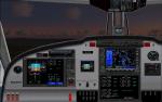
This upgrade to the Alphasim F-111 adds a Weapons System Operator Panel with default and old avionics packages, Working TERRAIN FOLLOWING RADAR scope
shows accurate ground mapping ahead of aircraft in 5, 10 or 15 mile ranges, THREAT WARNING DISPLAY shows airborne AI aircraft in 20 or 40 mile ranges, Ground Attack RADAR displays airports and AI aircraft on default panel and airports as ground targets in ranges of 5,10,30,80 and 200 miles on old avionics panel, Shockwave Lights ready, Updated afterburner effects, INS (old avionics panel) displays working digital readout of latitude, longitude, and altitude, TFR and TWR gauges automatically change brightness between day and night to match lighting conditions.New Autopilot and Lighting control panels. Features custom gauges created by Dietmar Loleit for this project. You must have the Alphasim F-111 aircraft package.
Panel by Steve Hess
Posted Jul 19, 2009 08:33 by Steve Hess
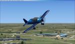
1.77Mb (779 downloads)
Textures only for the Premier Aircraft Design Robin R2160/Alpha 160A
Required files:
required file
Posted Jul 18, 2009 19:47 by Stu Redman