


FSX > Page 1856
42.93Mb (20206 downloads)
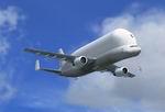
This is the UKFlightsim Airbus A300B1 for FSX. This package contains 1 model and 1 Texture Sets. Created by Jonathan Reeves, Tom Ruth, Dave Hazelgrove and Emil Serafino Jr.
Posted Apr 15, 2009 16:29 by Jon Reeves
5.05Mb (1518 downloads)
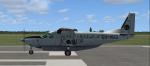
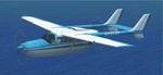
Textures only for the Default FSX Cessna 208B Grand Caravan in the colours of Coastal Aviation of Dar es Salaam, Tanzania
Posted Apr 15, 2009 16:10 by Bashir Ismail
7.99Mb (3899 downloads)
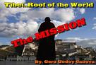
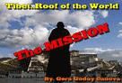
" Dog weather!!!!, why did I get into this!!!!! I should have stayed with my dog in Bali!!!!! a Tzunami is better than this!!!!"....words spoken by your pilot as she gets nervous and hands the plane to you!!!!!!!!!!!!!!!!.....--"What?? you cry out...now you give me the darn plane!!!!! what's the matter with you Sonia?? you said you were going to land, woman!!!!!!!....... Yes...this is how the Mission starts as the Beechcraft begins its approach to Paro, Bhutan...............weather?, yup.....lousy as the sky of hell!!! and low down in that gully called Paro is your destination.... If you get through Episode I (not a great chance) you then fly out to the forbidden land of Tibet..........be good and Budda's finger will be your guide.... "Hang-shi-lu-mai Tsung Tsung", like the old master used to say ( before they had coke!!). Ching-Chu-Gui ---
Posted Apr 14, 2009 16:33 by Gera Godoy Canova
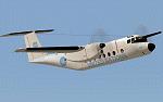
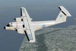
21.10Mb (17329 downloads)
FSX De Havilland CC-115 (DHC-5) Buffalo, Canadian Forces.
This model depicts CC-115 s/n 115461 in United Nations peacekeeping livery. On August 9th 1974 this aircraft was shot down by Syrian SAM missiles whilst flying from Beirut to Damascus on U.N. peacekeeping duties. The aircraft was completely destroyed and the crew of 9 were all lost. As a tribute to the crew, the Canadian Warplane Heritage Museum (CWH), Hamilton, Ontario has restored a derelict Buffalo to static display condition and painted it to replicate 115461 in it's U.N. livery. This restored aircraft is now on public display and CWH are also using MSFS, with this PAD model loaded, to give visitors a feel of how 461 looked when operational.
Full package for FSX/SP2, panel, VC and custom sounds. Full model animations including animated flight crew. Flying tips and html check/ref lists included.
By Jean-Pierre Brisard and Bob May - Premier Aircraft Design.
Posted Apr 14, 2009 15:54 by bob.may@premaircraft.com
6.15Mb (1550 downloads)
Beira is the second largest city in Mozambique. This Airport/scenery is an improvement over the Default in FSX
Posted Apr 14, 2009 14:51 by Bashir Ismail
67.00Mb (16330 downloads)
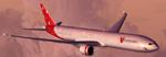
Project Opensky 777-300 V2. Model features High resolution textures, Dynamic flexing wings, Body gear steering, Nose gear steering, Rudder lock, Ground spoilers, Low speed aileron locks at high speed, Fully animated control surfaces, Fully independent suspension, Trim Animation, Opening Passenger Doors, Animated tilting bogies, semi-transparent fan textures [carried over form the -200 series], Rolling wheels, Animated thrust reverser's with reverser block doors, Detailed textures, Full night lighting, Crash affects, Ground Service Vehicles And more. Model Designer Hiroshi Igami/Yosuke Ube. Flight Dynamics Designer Brandon D Henry. Tested by Project Open Sky Members. Textures by Ben Jones/Yosuke Ube. Livery by Leigh Ellis (RAF_Leigh)
Posted Apr 14, 2009 11:24 by Leigh Ellis
0.16Mb (6352 downloads)
This is an updated update for FS X acceleration, of the Cessna 337 Skymaster by Mike Stone. I did not remember that I had changed the sound.cfg file when I put the original update together; so I have added a corrected sound.cfg file so there will be sound. Most of what was needed was to update the panel and adjust some lights. You need the original aircraft for this to work. No virtual cockpit. IF YOU ALREADY HAVE MY UPDATED UPDATE FOR FSX OF THIS AIRCRAFT ALL YOU NEED TO DO IS OPEN THE AIRCRAFT.CFG FILE AND PAGE DOWN TO THE [AIRSPEED_INDICATORS] SECTION AND MAKE SURE IT READS "airspeed_indicator.0 = 1" WITHOUT THE QUOTES. DELETE ANYTHING AFTER THE ONE. FOR EVERYONE ELSE THIS UPDATE IS THE ONE YOU NEED. Bob Chicilo.
Required files:
required file
Posted Apr 14, 2009 03:31 by Bob Chicilo
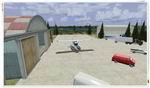
0.55Mb (1286 downloads)
CBQ2 - Fort Langley, BC
Welcome to Fort Langley!
Located in the Township of Langley, Fort Langley is about a 45 min drive from Vancouver as well as
the USA border crossing. They are conveniently located near the #1 Hwy and the Albion Ferry crossing.
The Langley area was the first part of the lower mainland of British Columbia where European settlement was established.
Fort Langley was built in 1827 under the direction of James McMillan, Chief Trader of the Hudson's Bay Company.
It was situated about 50 kilometres (30 miles) from the mouth of the Fraser River. The prime objectives of the Fort were
to establish a fur trading post and to initiate some agricultural activities, which would secure a steady supply of food
for the occupants of the various fur trading posts west of the Rockies.
Posted Apr 14, 2009 03:29 by Daniel Louvet
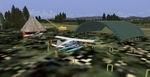
0.92Mb (1606 downloads)
CYPK - Pitt Meadows, BC.
Welcome to Pitt Meadows Airport!
Pitt Meadows Regional Airport is centrally located in the District of Pitt Meadows, north of the Fraser River, serving the Lower
Mainland and Fraser Valley regions. It is 2.5 km east of the junction of the Pitt and Fraser Rivers, and only a 45-minute drive
to downtown Vancouver, and 40 minutes to Abbotsford and the Fraser Valley.
I have enhanced the airport and...the harbour. Multiple buildings and flight school/Heli school area.
The marina has been developped to accomodate up to 5 seaplanes and has a Fuel ramp as well. keep an eye on the marine life when inbound! ;)
night lighting in effect and taxi signs in place. Hope you will enjoy your stop over in CYPK weither by land or Sea plane!
Posted Apr 14, 2009 03:27 by Daniel Louvet
0.00Mb (619 downloads)
FSX Afcad for Wako Kungo, Angola, Africa. For use with FSX default Scenery. By Joao Angerino
Posted Apr 13, 2009 18:37 by Joao Angerino