


FSX > Terrain Mesh > Page 42
62.21Mb (2226 downloads)
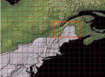
USA EAST USGS 10 metre mesh terrain Includes: MN, MI, NH, ME, WI. - FSX only.
This constitutes 10 metre terrain mesh for a section of the USA, The whole USA East mesh files will abutt the US West Coast 10m mesh already available, that was made by: Raimondo Taburet. Make sure you have your scenery terrain settings at about 5 metres in the FSX display dialogue for the mesh to show properly!
Posted May 20, 2009 05:04 by Wayne Evans

23.12Mb (2397 downloads)
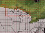
FSX USA 10 Metre Mesh, Batch 1 Part 3. USA EAST USGS 10 metre mesh terrain - FSX only.
This constitutes 10 metre terrain mesh for a section of the USA, The whole USA East mesh files will abutt the US West Coast 10m mesh already available, that was made by: Raimondo Taburet. Make sure you have your scenery terrain settings at about 5 metres in the FSX display dialogue for the mesh to show properly! Click Previous Page button below to go to FSX Mesh page in old system!
Posted May 19, 2009 06:52 by Wayne Evans
45.98Mb (2212 downloads)
USA EAST USGS 10 metre mesh terrain - FSX only.
This constitutes 10 metre terrain mesh for a section of the USA, The whole USA East mesh files will abutt the US West Coast 10m mesh already available, that was made by: Raimondo Taburet. Make sure you have your scenery terrain settings at about 5 metres in the FSX display dialogue for the mesh to show properly! Click Previous Page button below to go to FSX Mesh page in old system!
Posted May 19, 2009 06:36 by Wayne Evans

69.24Mb (2667 downloads)
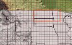
USA EAST USGS 10 metre mesh terrain - FSX only. Batch1, part 1. Includes: ND, SD, MN (three parts this batch)
This constitutes 10 metre terrain mesh for a section of the USA, The whole USA East mesh files will abutt the US West Coast 10m mesh already available, that was made by: Raimondo Taburet. Make sure you have your scenery terrain settings at about 5 metres in the FSX display dialogue for the mesh to show properly!
Click Previous Page button below to go to FSX Mesh page in old system!
Posted May 19, 2009 06:06 by Wayne Evans
34.00Mb (13351 downloads)
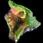
FSX 10 meter Mesh for Hawaii. The zip file contains mesh terrain files for the eight principal islands of Hawai'i. The data supplied by the USGS Seamless server was corrected to the necessary datum in use by FSX and any gaps interpolated using Global Mapper. The files were then resampled by the FSX SDKs. A FractionalBits setting of three was used, except for the island of Hawai'i where the elevations of Mauna Loa and Mauna Kea were beyond a FB=3 setting parameter. So the island of Hawai'i was resampled with a FractionalBits setting of two. In common speak, the FractionalBits settings allows for a higher degree of processing between the data points, which helps to eliminate any "stair-stepping" effect. Lance Tucker. 34.8MB
Posted Jun 6, 2008 14:02 by archive