


FSX > Terrain Mesh > Page 37
148.22Mb (30883 downloads)
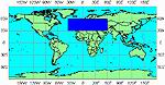
Europe
FSX
FSX World Wide SRTM 38M Mesh Europe Part 1. Includes the
complete set of SRTM 3, version 2, 75M mesh files for Europe.
This package is part of the freeware worldwide SRTM 3 v2 coverage
project. In 2 Parts. By Raimondo Taburet and J. De Ferranti.
155MB
Part
2 186MB
Posted Jun 26, 2009 07:08 by archive

21.13Mb (2263 downloads)
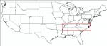
USA EAST USGS 10 metre mesh terrain - FSX only.
This constitutes 10 metre terrain mesh for a section of the USA, The whole USA East mesh files will abutt the US West Coast 10m mesh already available, that was made by: Raimondo Taburet. Make sure you have your scenery terrain settings at about 5 metres in the FSX display dialogue for the mesh to show properly! Includes: MO, AR, KY, TN, MS, AL, VA, GA, NC, SC.
Posted Jun 21, 2009 08:31 by Wayne Evans

53.81Mb (1965 downloads)
USA EAST USGS 10 metre mesh terrain - FSX only.
This constitutes 10 metre terrain mesh for a section of the USA, The whole USA East mesh files will abutt the US West Coast 10m mesh already available, that was made by: Raimondo Taburet. Make sure you have your scenery terrain settings at about 5 metres in the FSX display dialogue for the mesh to show properly! Includes: MO, AR, KY, TN, MS, AL, VA, GA, NC, SC.
Posted Jun 21, 2009 08:15 by Wayne Evans

69.66Mb (2189 downloads)
USA EAST USGS 10 metre mesh terrain - FSX only.
This constitutes 10 metre terrain mesh for a section of the USA, The whole USA East mesh files will abutt the US West Coast 10m mesh already available, that was made by: Raimondo Taburet. Make sure you have your scenery terrain settings at about 5 metres in the FSX display dialogue for the mesh to show properly! Includes: MO, AR, KY, TN, MS, AL, VA, GA, NC, SC.
Posted Jun 21, 2009 07:38 by Wayne Evans
62.78Mb (2146 downloads)
USA EAST USGS 10 metre mesh terrain - FSX only.
This constitutes 10 metre terrain mesh for a section of the USA, The whole USA East mesh files will abutt the US West Coast 10m mesh already available, that was made by: Raimondo Taburet. Make sure you have your scenery terrain settings at about 5 metres in the FSX display dialogue for the mesh to show properly! Includes: MO, AR, KY, TN, MS, AL, VA, GA, NC, SC.
Posted Jun 21, 2009 06:54 by Wayne Evans

62.42Mb (1941 downloads)
USA EAST USGS 10 metre mesh terrain - FSX only.
This constitutes 10 metre terrain mesh for a section of the USA, The whole USA East mesh files will abutt the US West Coast 10m mesh already available, that was made by: Raimondo Taburet. Make sure you have your scenery terrain settings at about 5 metres in the FSX display dialogue for the mesh to show properly! Includes: MO, AR, KY, TN, MS, AL, VA, GA, NC, SC.
Posted Jun 21, 2009 05:54 by Wayne Evans

62.61Mb (1985 downloads)
USA EAST USGS 10 metre mesh terrain - FSX only.
This constitutes 10 metre terrain mesh for a section of the USA, The whole USA East mesh files will abutt the US West Coast 10m mesh already available, that was made by: Raimondo Taburet. Make sure you have your scenery terrain settings at about 5 metres in the FSX display dialogue for the mesh to show properly! Includes: MO, AR, KY, TN, MS, AL, VA, GA, NC, SC.
Posted Jun 21, 2009 05:14 by Wayne Evans

59.87Mb (2205 downloads)
USA EAST USGS 10 metre mesh terrain - FSX only.
This constitutes 10 metre terrain mesh for a section of the USA, The whole USA East mesh files will abutt the US West Coast 10m mesh already available, that was made by: Raimondo Taburet. Make sure you have your scenery terrain settings at about 5 metres in the FSX display dialogue for the mesh to show properly! Includes: MO, AR, KY, TN, MS, AL, VA, GA, NC, SC.
Posted Jun 21, 2009 04:30 by Wayne Evans
372.51Mb (4306 downloads)
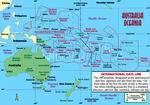
Oceania - Asia SRTM Terrain Mesh for FSX Part 5 Covers Australia, New Zealand (including Auckland Islands & Macquarie Island), PNG/Irian Jaya, Indonesia, Malaysia, Philippines, Taiwan, Japan, Korea, Micronesia, Solomon Islands, New Caledonia, Vanuatu, Fiji Islands and all other Pacific Islands (except The Hawaiian Islands). This Mesh is PROCESSED FROM SRTM DATA VERSIONS 3 and 4.1 and Complied using Global Mapper & FSX SDK. Thomas Trewin
Posted Jun 19, 2009 15:35 by Thomas Trewin

136.86Mb (3329 downloads)
Oceania - Asia SRTM Terrain Mesh for FSX Part 4 Covers Australia, New Zealand (including Auckland Islands & Macquarie Island), PNG/Irian Jaya, Indonesia, Malaysia, Philippines, Taiwan, Japan, Korea, Micronesia, Solomon Islands, New Caledonia, Vanuatu, Fiji Islands and all other Pacific Islands (except The Hawaiian Islands). This Mesh is PROCESSED FROM SRTM DATA VERSIONS 3 and 4.1 and Complied using Global Mapper & FSX SDK. Thomas Trewin
Posted Jun 19, 2009 13:40 by Thomas Trewin