


FSX > Terrain Mesh > Page 35

60.62Mb (2230 downloads)
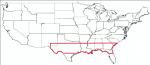
USA South East USGS 10 metre mesh terrain - FSX only.
This constitutes 10 metre terrain mesh for a section of the USA, The whole USA East mesh files will abutt the US West Coast 10m mesh already available, that was made by: Raimondo Taburet. Make sure you have your scenery terrain settings at about 5 metres in the FSX display dialogue for the mesh to show properly! Includes: NM, TX, LA, MS, AL, FL, GA, SC.
Posted Jul 20, 2009 07:38 by Wayne Evans
53.88Mb (2328 downloads)
USA South East USGS 10 metre mesh terrain - FSX only.
This constitutes 10 metre terrain mesh for a section of the USA, The whole USA East mesh files will abutt the US West Coast 10m mesh already available, that was made by: Raimondo Taburet. Make sure you have your scenery terrain settings at about 5 metres in the FSX display dialogue for the mesh to show properly! Includes: NM, TX, LA, MS, AL, FL, GA, SC.
Posted Jul 20, 2009 06:57 by Wayne Evans
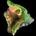
34.00Mb (4755 downloads)
FSX
10 meter Mesh for Hawaii. The
zip file contains mesh terrain files for the eight principal
islands of Hawai'i. The data supplied by the USGS Seamless server
was corrected to the necessary datum in use by FSX and any gaps
interpolated using Global Mapper. The files were then resampled
by the FSX SDKs. A FractionalBits setting of three was used,
except for the island of Hawai'i where the elevations of Mauna
Loa and Mauna Kea were beyond a FB=3 setting parameter. So the
island of Hawai'i was resampled with a FractionalBits setting
of two. In common speak, the FractionalBits settings allows
for a higher degree of processing between the data points, which
helps to eliminate any "stair-stepping" effect. Lance
Tucker. 34.8MB
Posted Jun 26, 2009 07:08 by archive
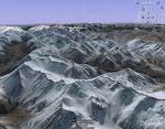
31.62Mb (4513 downloads)
FSX
New Zealand Terrain Mesh.
These files have had extensive work done on them to remove all
voids giving you the user much better STRM Terrain Mesh for
both the North and South Island of New Zealand. J.Harris. 32.4MB
Posted Jun 26, 2009 07:08 by archive
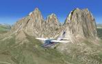
293.32Mb (7048 downloads)
FSX
ItalVFR - Trentino Alto Adige 2M Photorealistic Scenery &
Mesh Package. This scenery cover the whole of the Trentino
Alto Adige (Italy/Switzerland/French Alps) ) with photorealistic
scenery 2 m resolution - Summer only - part of the ItalVFR
photorealistic scenery of Italy.by: Raimondo Taburet.
Part
1: 300MB
Part
2: 229MB
Part
3: 389MB
Part
4: 387MB
Part
5: 263MB
Part
6: 260MB
Part
7: 373MB
Posted Jun 26, 2009 07:08 by archive
257.50Mb (5829 downloads)
FS
X - Canada 19 M - Terrain Mesh - Part 1 The
canada 19 m terrain mesh fsx is designed using the cded elevation
models data - geobase.ca - It offers an improved terrain mesh
for the whole of Canada - This is File 1 - of Canada 19 m
freeware project. It is good - fun to fly over and Free !
All FSX mesh files compiled by myself are all designed to
work along each other - to provide the ultimate Freeware Mesh
Worldwide Coverage for the all continents. Designed by: Raimondo
Taburet. 263MB
FSX
Canada 19 M Terrain Mesh - Part 2
. 170MB
Posted Jun 26, 2009 07:08 by archive
1.48Mb (4077 downloads)
FSX
19 M Balearic Terrain Mesh
Specifically designed for FSX this is a highly detailed mesh
at 19M resolution for the Balearic Islands - it offers a far
higher levels of details than srtm terrains mesh. by: Raimondo
Taburet. 1.5MB
Posted Jun 26, 2009 07:08 by archive
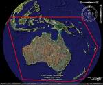
92.70Mb (3723 downloads)
FSX-STRM
Mesh for Australia, New Zealand and PNG (Papua New Guinea)
This STRM mesh will update your FSX default Mesh giving you
a much better resolution than the default mesh that comes
with default FSX. We have used the latest Data available fixing
all voids where possible. Thomas Trewin.
Part
1 95MB
Part
2 106MB
Part
3 51MB
Part
4 38MB
Posted Jun 26, 2009 07:08 by archive
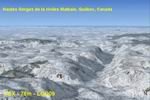
44.38Mb (2483 downloads)
FSX
38m (Lod10) Terrain Mesh files of the province of Quebec
(N45°-N52°, W56°-W80°). The 23 m (or 76m)
Canadian Digital Elevation Data for Quebec. http://www.geobase.ca
The 90-m digital elevation model (Shuttle Radar Topography
Mission - SRTM-3) ftp://edcsgs9.cr.usgs.gov/
pub/data/srtm/North_America/3arcsec/.
By Gilles Gauthier. Part 1 46MB
Part
2 45MB
Part
3 40MB
Part
4 44MB
Part
5 40MB
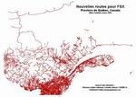
FSX
Quebec Roads. Addition of Roads for the province of Quebec,
Canada. For best scenery, use with lakes, shorelines and rivers
of the province of Quebec, Canada. Gilles Gauthier. 7.8MB
Posted Jun 26, 2009 07:08 by archive
71.97Mb (3090 downloads)
FSX
Canada 19MTerrain Mesh Area -Vancouver & surrounding area.
CDED 20 m elevation models. By Raimondo Taburet. 73.6MB
Posted Jun 26, 2009 07:08 by archive