


FSX > Terrain Mesh > Page 33
114.21Mb (2334 downloads)
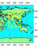
Includes a complete set of SRTM 3, version 2, mesh files
for West Asia - This package is part of the freeware world wide
SRTM 3 v 2 mesh coverage project in five parts. By Raimond Taburet and J. De ferranti
Posted Jan 4, 2011 22:54 by Chuck79

206.25Mb (3183 downloads)
Includes a complete set of SRTM 3, version 2, mesh files
for West Asia - This package is part of the freeware world wide
SRTM 3 v 2 mesh coverage project in five parts. By Raimond Taburet and J. De ferranti
Posted Jan 4, 2011 22:27 by Chuck79

242.74Mb (2599 downloads)
Includes a complete set of SRTM 3, version 2, mesh files
for West Asia - This package is part of the freeware world wide
SRTM 3 v 2 mesh coverage project in five parts. By Raimond Taburet and J. De ferranti
Posted Jan 4, 2011 21:44 by Chuck79

94.77Mb (2792 downloads)
Includes a complete set of SRTM 3, version 2, mesh files
for West Asia - This package is part of the freeware world wide
SRTM 3 v 2 mesh coverage project in five parts. By Raimond Taburet and J. De ferranti
Posted Jan 4, 2011 19:57 by Chuck79
62.66Mb (4870 downloads)
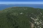
FSX Hawaii 10 m terrain mesh.
Terrain mesh covering the islands of Hawaii - at 10 m resolution.
Designed with the FS X Sdk - including multilod and it is frames rates
friendly. This is a complete new build - october 2010 - and replaces hawai_10.zip.
By Raimondo Taburet
Posted Oct 14, 2010 05:36 by Raimondo Taburet
108.80Mb (3152 downloads)
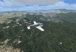
FSX - Sardinia, Italy, 10 m Mesh Build with the latest generation of terrain models from Sardegna's Region gis team ! 10 m at source - Lod 12 - this mesh scenery file cover the whole of Sardinia region in Italy. Sardinia (Italian: Sardegna) is the second-largest island in the Mediterranean Sea (after Sicily and before Cyprus). It is an autonomous region of Italy, and the nearest land masses are (clockwise from north) the French island of Corsica, the Italian Peninsula, Sicily, Tunisia and the Spanish Balearic Islands. By: Raimondo Taburet. This is Version 2 which fix some sea waters elevations.
by: Raimondo Taburet
Posted Oct 13, 2010 08:01 by Raimondo Taburet
84.16Mb (1987 downloads)
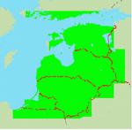
Mesh of Estonia, Latvia, Lithuania and Russia's Kaliningrad region (without west part
of Saaremaa, see image in archive).
Compression and conversion to bgl with MS Flight simulator SDK at LOD 10.
Based on SRTM 3 arc.sec data.
Some airports have minor elevation problems, and may need flatten files.
Other bug reports and comments are welcomed.
Install:
just copy this folder into the the FS folder called "Addon Scenery" and
set the new scenery active in the MSFS "Setting library".
You can also simply unzip this files into the scenery Base scenery directory of fs9 -
and it will work. Restart MSFS.
Posted Apr 23, 2010 11:08 by Matlley

14.54Mb (3456 downloads)
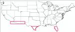
USA Southern States USGS 10 metre mesh terrain - FSX only.
This constitutes 10 metre terrain mesh for a section of the USA, The whole USA East mesh files will abutt the US West Coast 10m mesh already available, that was made by: Raimondo Taburet. Make sure you have your scenery terrain settings at about 5 metres in the FSX display dialogue for the mesh to show properly!
Batch 10 also contains 10 metre mesh for an area below 33 degrees latitude on the western part of the USA, this was missing in Raimondo Taburet's files. See jpg for coverage.
Includes: CA, AZ, NM, TX, FL.
Posted Aug 2, 2009 11:09 by Wayne Evans

25.06Mb (3084 downloads)
USA Southern States USGS 10 metre mesh terrain - FSX only.
This constitutes 10 metre terrain mesh for a section of the USA, The whole USA East mesh files will abutt the US West Coast 10m mesh already available, that was made by: Raimondo Taburet. Make sure you have your scenery terrain settings at about 5 metres in the FSX display dialogue for the mesh to show properly!
Batch 10 also contains 10 metre mesh for an area below 33 degrees latitude on the western part of the USA, this was missing in Raimondo Taburet's files. See jpg for coverage.
Includes: CA, AZ, NM, TX, FL.
Posted Aug 2, 2009 10:42 by Wayne Evans
40.16Mb (3228 downloads)
USA Southern States USGS 10 metre mesh terrain - FSX only.
This constitutes 10 metre terrain mesh for a section of the USA, The whole USA East mesh files will abutt the US West Coast 10m mesh already available, that was made by: Raimondo Taburet. Make sure you have your scenery terrain settings at about 5 metres in the FSX display dialogue for the mesh to show properly!
Batch 10 also contains 10 metre mesh for an area below 33 degrees latitude on the western part of the USA, this was missing in Raimondo Taburet's files. See jpg for coverage.
Includes: CA, AZ, NM, TX, FL.
Posted Aug 2, 2009 10:24 by Wayne Evans