


FSX > Terrain Mesh > Page 34
66.80Mb (3596 downloads)
USA Southern States USGS 10 metre mesh terrain - FSX only.
This constitutes 10 metre terrain mesh for a section of the USA, The whole USA East mesh files will abutt the US West Coast 10m mesh already available, that was made by: Raimondo Taburet. Make sure you have your scenery terrain settings at about 5 metres in the FSX display dialogue for the mesh to show properly!
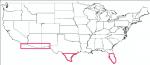
Batch 10 also contains 10 metre mesh for an area below 33 degrees latitude on the western part of the USA, this was missing in Raimondo Taburet's files. See jpg for coverage.
Includes: CA, AZ, NM, TX, FL.
Posted Aug 2, 2009 09:27 by Wayne Evans

32.30Mb (2514 downloads)
USA South East USGS 10 metre mesh terrain - FSX only.
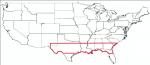
This constitutes 10 metre terrain mesh for a section of the USA, The whole USA East mesh files will abutt the US West Coast 10m mesh already available, that was made by: Raimondo Taburet. Make sure you have your scenery terrain settings at about 5 metres in the FSX display dialogue for the mesh to show properly! Includes: NM, TX, LA, MS, AL, FL, GA, SC.
Posted Jul 20, 2009 14:03 by Wayne Evans

16.33Mb (2309 downloads)
USA South East USGS 10 metre mesh terrain - FSX only.
This constitutes 10 metre terrain mesh for a section of the USA, The whole USA East mesh files will abutt the US West Coast 10m mesh already available, that was made by: Raimondo Taburet. Make sure you have your scenery terrain settings at about 5 metres in the FSX display dialogue for the mesh to show properly! Includes: NM, TX, LA, MS, AL, FL, GA, SC.
Posted Jul 20, 2009 13:13 by Wayne Evans

31.60Mb (2389 downloads)
USA South East USGS 10 metre mesh terrain - FSX only.
This constitutes 10 metre terrain mesh for a section of the USA, The whole USA East mesh files will abutt the US West Coast 10m mesh already available, that was made by: Raimondo Taburet. Make sure you have your scenery terrain settings at about 5 metres in the FSX display dialogue for the mesh to show properly! Includes: NM, TX, LA, MS, AL, FL, GA, SC.
This BGL file has a half degree block missing due to bad data occuring in the USGS GeoTIFF file I downloaded.
Tried fixing it...but to no avail.
The missing block covers a rectangle with its bottom left corner at: Lat: 30.0000, Long: -83.5000, and its top right hand corner at: Lat: 31.0000, Long: -83.0000.
See jpg image in folder.
Posted Jul 20, 2009 12:45 by Wayne Evans

45.17Mb (2382 downloads)
USA South East USGS 10 metre mesh terrain - FSX only.
This constitutes 10 metre terrain mesh for a section of the USA, The whole USA East mesh files will abutt the US West Coast 10m mesh already available, that was made by: Raimondo Taburet. Make sure you have your scenery terrain settings at about 5 metres in the FSX display dialogue for the mesh to show properly! Includes: NM, TX, LA, MS, AL, FL, GA, SC.
Posted Jul 20, 2009 12:09 by Wayne Evans

42.82Mb (3320 downloads)
USA South East USGS 10 metre mesh terrain - FSX only.
This constitutes 10 metre terrain mesh for a section of the USA, The whole USA East mesh files will abutt the US West Coast 10m mesh already available, that was made by: Raimondo Taburet. Make sure you have your scenery terrain settings at about 5 metres in the FSX display dialogue for the mesh to show properly! Includes: NM, TX, LA, MS, AL, FL, GA, SC.
Posted Jul 20, 2009 11:30 by Wayne Evans

48.24Mb (1911 downloads)
USA South East USGS 10 metre mesh terrain - FSX only.
This constitutes 10 metre terrain mesh for a section of the USA, The whole USA East mesh files will abutt the US West Coast 10m mesh already available, that was made by: Raimondo Taburet. Make sure you have your scenery terrain settings at about 5 metres in the FSX display dialogue for the mesh to show properly! Includes: NM, TX, LA, MS, AL, FL, GA, SC.
Posted Jul 20, 2009 11:02 by Wayne Evans
25.98Mb (1972 downloads)
USA South East USGS 10 metre mesh terrain - FSX only.
This constitutes 10 metre terrain mesh for a section of the USA, The whole USA East mesh files will abutt the US West Coast 10m mesh already available, that was made by: Raimondo Taburet. Make sure you have your scenery terrain settings at about 5 metres in the FSX display dialogue for the mesh to show properly! Includes: NM, TX, LA, MS, AL, FL, GA, SC.
Posted Jul 20, 2009 10:26 by Wayne Evans

58.60Mb (2125 downloads)
USA South East USGS 10 metre mesh terrain - FSX only.
This constitutes 10 metre terrain mesh for a section of the USA, The whole USA East mesh files will abutt the US West Coast 10m mesh already available, that was made by: Raimondo Taburet. Make sure you have your scenery terrain settings at about 5 metres in the FSX display dialogue for the mesh to show properly! Includes: NM, TX, LA, MS, AL, FL, GA, SC.
Posted Jul 20, 2009 08:46 by Wayne Evans

46.30Mb (2056 downloads)
USA South East USGS 10 metre mesh terrain - FSX only.
This constitutes 10 metre terrain mesh for a section of the USA, The whole USA East mesh files will abutt the US West Coast 10m mesh already available, that was made by: Raimondo Taburet. Make sure you have your scenery terrain settings at about 5 metres in the FSX display dialogue for the mesh to show properly! Includes: NM, TX, LA, MS, AL, FL, GA, SC.
Posted Jul 20, 2009 08:09 by Wayne Evans