


10.16Mb (5801 downloads)
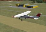
This scenery updates NZCH airport. It adds the Canterbury Aero Club to the western side of the airport, and an AFCAD that places things where they really are in real life. This is V1.0. This scenery also includes my small airfields scenery too. This scenery comes with airport charts for NZCH,NZWL,NZRT and NZFF.
By Troy Chapman.
Posted Oct 8, 2008 16:07 by Troy Chapman.
74.34Mb (1169 downloads)
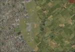
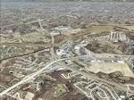
FSX St Louis PhotoReal Scenery. This is high resolution, 1 meter/pixel, terrain scenery for St Louis, Missouri (MO). Section, U, is one of 30. A map and descriptions show the section locations and some feature details. This photoscenery is for DAY USE ONLY and will work for any season, but shows only the USGS aerial photo data taken in March 2002. The default FSX mesh works well with this photoscenery and no additional mesh for the area needs to be purchased. The 30 sections of scenery, totalling 2 Gb, contains photoreal terrain textures, encompassing an area bounded by 31.7 E-W and 27.4 N-S miles (about 870 square miles). Each section is independent, but the user may want most or all sections to provide continuity and completeness. By Jim Jones.
Posted Oct 8, 2008 06:48 by Jim Jones
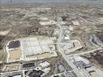
72.11Mb (1110 downloads)
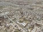
FSX St Louis PhotoReal Scenery. This is high resolution, 1 meter/pixel, terrain scenery for St Louis, Missouri (MO). Section, V, is one of 30. A map and descriptions show the section locations and some feature details. This photoscenery is for DAY USE ONLY and will work for any season, but shows only the USGS aerial photo data taken in March 2002. The default FSX mesh works well with this photoscenery and no additional mesh for the area needs to be purchased. The 30 sections of scenery, totalling 2 Gb, contains photoreal terrain textures, encompassing an area bounded by 31.7 E-W and 27.4 N-S miles (about 870 square miles). Each section is independent, but the user may want most or all sections to provide continuity and completeness. By Jim Jones.
Posted Oct 8, 2008 06:48 by Jim Jones
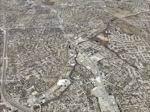
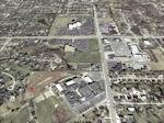
74.30Mb (1097 downloads)
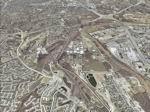
FSX St Louis PhotoReal Scenery. This is high resolution, 1 meter/pixel, terrain scenery for St Louis, Missouri (MO). Section, W, is one of 30. A map and decriptions show the section locatons and some feature details. This photoscenery is for DAY USE ONLY and will work for any season, but shows only the USGS aerial photo data taken in March 2002. The default FSX mesh works well with this photoscenery and no additional mesh for the area needs to be purchased. The 30 sections of scenery, totaling 2 Gb, contains photoreal terrain textures, encompassing an area bounded by 31.7 E-W and 27.4 N-S miles (about 870 square miles). Each section is independant, but the user may want most or all sections to provide continutiy and completeness. By Jim Jones.
Posted Oct 8, 2008 06:15 by Jim Jones
71.05Mb (1209 downloads)
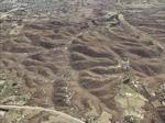
FSX St Louis PhotoReal Scenery. This is high resolution, 1 meter/pixel, terrain scenery for St Louis, Missouri (MO). Section, X, is one of 30. A map and decriptions show the section locations and some feature details. This photoscenery is for DAY USE ONLY and will work for any season, but shows only the USGS aerial photo data taken in March 2002. The default FSX mesh works well with this photoscenery and no additional mesh for the area needs to be purchased. The 30 sections of scenery, totaling 2 Gb, contains photoreal terrain textures, encompassing an area bounded by 31.7 E-W and 27.4 N-S miles (about 870 square miles). Each section is independant, but the user may want most or all sections to provide continutiy and completeness. By Jim Jones.
Posted Oct 8, 2008 06:10 by Jim Jones
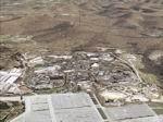
75.33Mb (1141 downloads)
FSX St Louis PhotoReal Scenery. This is high resolution, 1 meter/pixel, terrain scenery for St Louis, Missouri (MO). Section, T, is one of 30. A map and descriptions show the section locations and some feature details. This photoscenery is for DAY USE ONLY and will work for any season, but shows only the USGS aerial photo data taken in March 2002. The default FSX mesh works well with this photoscenery and no additional mesh for the area needs to be purchased. The 30 sections of scenery, totalling 2 Gb, contains photoreal terrain textures, encompassing an area bounded by 31.7 E-W and 27.4 N-S miles (about 870 square miles). Each section is independent, but the user may want most or all sections to provide continuity and completeness. By Jim Jones.
Posted Oct 8, 2008 03:58 by Jim Jones
73.51Mb (1012 downloads)
FSX St Louis PhotoReal Scenery. This is high resolution, 1 meter/pixel, terrain scenery for St Louis, Missouri (MO). Section, S, is one of 30. A map and descriptions show the section locations and some feature details. This photoscenery is for DAY USE ONLY and will work for any season, but shows only the USGS aerial photo data taken in March 2002. The default FSX mesh works well with this photoscenery and no additional mesh for the area needs to be purchased. The 30 sections of scenery, totaling 2 Gb, contains photoreal terrain textures, encompassing an area bounded by 31.7 E-W and 27.4 N-S miles (about 870 square miles). Each section is independent, but the user may want most or all sections to provide continuity and completeness. By Jim Jones.
Posted Oct 8, 2008 03:56 by Jim Jones
76.26Mb (1021 downloads)
FSX St Louis PhotoReal Scenery. This is high resolution, 1 meter/pixel, terrain scenery for St Louis, Missouri (MO). Section, Q, is one of 30. A map and descriptions show the section locations and some feature details. This photoscenery is for DAY USE ONLY and will work for any season, but shows only the USGS aerial photo data taken in March 2002. The default FSX mesh works well with this photoscenery and no additional mesh for the area needs to be purchased. The 30 sections of scenery, totalling 2 Gb, contains photoreal terrain textures, encompassing an area bounded by 31.7 E-W and 27.4 N-S miles (about 870 square miles). Each section is independent, but the user may want most or all sections to provide continuity and completeness. By Jim Jones.
Posted Oct 8, 2008 02:57 by Jim Jones
74.95Mb (1102 downloads)
FSX St Louis PhotoReal Scenery. This is high resolution, 1 meter/pixel, terrain scenery for St Louis, Missouri (MO). Section, P, is one of 30. A map and descriptions show the section locations and some feature details. This photoscenery is for DAY USE ONLY and will work for any season, but shows only the USGS aerial photo data taken in March 2002. The default FSX mesh works well with this photoscenery and no additional mesh for the area needs to be purchased. The 30 sections of scenery, totalling 2 Gb, contains photoreal terrain textures, encompassing an area bounded by 31.7 E-W and 27.4 N-S miles (about 870 square miles). Each section is independent, but the user may want most or all sections to provide continuity and completeness. By Jim Jones.
Posted Oct 8, 2008 02:56 by By Jim Jones
23.83Mb (2682 downloads)
Some small changes to this scenery.
The airport name is FSXF-Oceana NAS (KNTU), Added hangers, vehicles, STATIC F-18S,CHOPPERS,B-747, MD-80.
Added ILS approaches, 05L 110.70MHz, 05R108.95MHz, 14R 109.35MHz, 14L 110.75MHz, VOR Ident ONS.,
new starts, helipads etc...
Posted Oct 8, 2008 02:43 by Thunder