


2.66Mb (4166 downloads)
This updates the NZCH Airport Scenery file, found here: http://www.simviation.com/simviation/index.php?type=item&ID= ..
It adds the terminal building to the airport and moves parking spaces to the correct position.
Read the Readme for full instructions and copyright information.
By Troy Chapman.
Posted Oct 17, 2008 18:54 by Troy Chapman.
0.23Mb (1295 downloads)
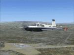
This is a scenery update for Watsonville Municipal Airport in Watsonville, California. Taxiways, runways, building positions, and other aspects were updated using satellite images from Google Earth for accuracy. Many default scenery objects from the FSX libraries were used. View Readme file for installation and notes. Compiled using Airport Design Editor.
Posted Oct 16, 2008 19:46 by Phillip Coyle
1.59Mb (1891 downloads)
Updated file structure, moved NDB on top of Helo padS decks by request for ADF approaches.
Layafette oil platform, The airport name is Lafayette Oil Platform.(KLFO) The NDB(none directional beacon) IDENT: LOPU, frequency 477.0 Khz.,
NDB range 100 NM, VOR ident: LOP. Layafette Oil platform is 65 NM. South of Layafette Regl. Louisiana-KLFT
Galveston oil platform, The airport name is Galveston oil platform. (KGLO) The NDB ident:GOPO, Frequency 396.0 Khz., range 100 NM.
VOR ident: GOP. Galveston oil platform is 7 NM. South of Scholes Intl. at Galveston Texas-KGLS
Carrier near the Galveston oil platform, NDB ident: GCGC, Frequency 233.0 Khz., range 100 NM. VOR ident: GCG.
Corpus Christi oil platform, The airport name is Corpus Christi oil platform. (KNGO) The NDB ident: CCOP, Frequency 391.0 Khz. NDB. range 100 NM.
VOR ident: CCO. Corpus Christi oil platform is 7 NM. South of Corpus Christi NAS. Texas-KNGP
Posted Oct 15, 2008 08:07 by Thunder
10.78Mb (2469 downloads)
Updated,This is the same as V3.0 But I've changed all scenery objects to Very Dense except the two carriers. Spaced ships out to address a common frame rate complaint,
Added another NDB, one for both carriers-Both on decks/Added buildings along Oceanas coastline.
-Carriers/Cruisers/Destroyers,(Arrestor cables work) Choopers on decks, Added LOC/DME Carrier1-R1 108.95Mhz Ident IABA Cat II, Carrier2-R2 109.30Mhz Ident IABB Cat III, NO BACK COARSE OR GLIDE SLOPE.
The airport name is FSXF-CarrierGroupOceana.(KNTC) The NDB(none directional beacon) frequency is 401.0Khz Carrier-1, 534.0Khz Carrier-2, range 100 NM. VOR-IDENT:OCG.
Naval Fleet is 12 NM. North-East of Oceana NAS.
Posted Oct 15, 2008 07:59 by Thunder
10.88Mb (3013 downloads)
Updated,This is the same as V3.0 But I've changed all scenery objects to Very Dense except the two carriers, and spaced ships out to address a common frame rate complaint, Added another NDB,
one for both carriers-Both on decks.
Carriers/Cruisers/Destroyers(Arrestor cables work), Choopers on decks, Added LOC/DME Carrier1 CAT II Ident IABC-RW 1 108.55 Mhz, Carrier2 CAT III Ident IABB-RW 2 108.10 Mhz. NO BACK COARSE,OR GLIDE SLOPE.
The airport name is FSXF-CarrierGroupMiramar.(FCBG) The NDB(none directional beacon) frequency is 235.0Khz for Carrier 1, and 455.0Khz for Carrier 2.
Range 100 NM. VOR-IDENT:MCG. Naval Fleet is 60 NM. west of Miramar MCAS.
Posted Oct 15, 2008 07:47 by Thunder
0.00Mb (3875 downloads)
LOWK-Klagenfurt, Austria Scenery. By Thomas Rath
Posted Oct 11, 2008 12:38 by Thomas Rath
0.01Mb (5376 downloads)
LOWI-Innsbruck, Austria. My 1st scenery design. By Thomas Rath
Posted Oct 11, 2008 12:32 by Thomas Rath
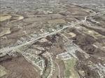
73.45Mb (1156 downloads)
FSX St Louis PhotoReal Scenery. This is high resolution, 1 meter/pixel, terrain
scenery for St Louis, Missouri (MO). Section Z, is one of 30. A map and
descriptions show the section locations and some feature details. This
photoscenery is for DAY USE ONLY and will work for any season, but shows only
the USGS aerial photo data taken in March 2002. The default FSX mesh works well
with this photoscenery and no additional mesh for the area needs to be
purchased. The 30 sections of scenery, totalling 2 Gb, contains photoreal terrain
textures, encompassing an area bounded by 31.7 E-W and 27.4 N-S miles (about 870
square miles). Each section is independent, but the user may want most or all
sections to provide continuity and completeness. By Jim Jones.
Posted Oct 11, 2008 05:30 by Jim Jones
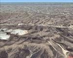
71.16Mb (1142 downloads)
FSX St Louis PhotoReal Scenery. This is high resolution, 1 meter/pixel, terrain scenery for St Louis, Missouri (MO). Section, Y, is one of 30. A map and decriptions show the section locatons and some feature details. This photoscenery is for DAY USE ONLY and will work for any season, but shows only the USGS aerial photo data taken in March 2002. The default FSX mesh works well with this photoscenery and no additional mesh for the area needs to be purchased. The 30 sections of scenery, totaling 2 Gb, contains photoreal terrain textures, encompassing an area bounded by 31.7 E-W and 27.4 N-S miles (about 870 square miles). Each section is independant, but the user may want most or all sections to provide continutiy and completeness. By Jim Jones.
Posted Oct 11, 2008 05:27 by Jim Jones
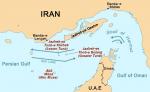
1.50Mb (3296 downloads)
This scenery is good for missions.
The airport name is FSX -Carrier/Strait of Hormuz, the carrier is off the coast of Oman in the Strait of Hormuz.
Has a few Cruisers and Destroyers around it, as a carrier battle group. Carrier has LOC/DME 109.15 Mhz. 30 NM. range(no back coarse or glide sloap).
NBD Frequency is 212 Khz., with a range of 100 NM. VOR ident: FSH .
Posted Oct 10, 2008 21:36 by Thunder