


FSX > Page 1166
64.30Mb (332 downloads)
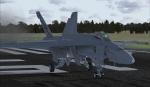
RAAF 1 Squadron textures for the payware VRS Superbug. There are all 12 aircraft in this Pack A44-201 to A44-212 please import through the ACM
Posted Jan 15, 2013 22:52 by Barry Wynd (AKA Kartikeya)
20.10Mb (526 downloads)
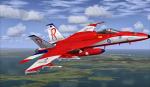
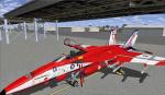
Fictional repaints for the payware VRS Superbug of the RAAF Roulettes Display Team. Import Via ACM
Posted Jan 15, 2013 21:43 by Barry Wynd (AKA Kartikeya)

27.59Mb (2986 downloads)
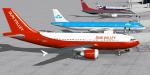
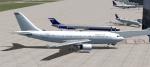
FSX Sun Valley Airlines textures only 5-pack: (Base files required) : Thomas Ruth Airbus
A310-300 Sun Valley passenger (with VC), Thomas Ruth Airbus A310-300F Sun
Valley cargo (with VC), iSDT ATR42-300 Sun Valley Express commuter (no VC),
SGA-Cantu Douglas DC-9-10 Sun Valley Express commuter (no VC), and
Sun Valley Airlines employee flying club default FSX Cessna 172SP
Skyhawk (VC analog gauges). Screenshots enclosed. Easy installation.
Repaints by Tom Tiedman.
Posted Jan 15, 2013 13:19 by Tom Tiedman

18.92Mb (5258 downloads)
FSX/FSX acceleration Martin Mars waterbomber
On 23 August 1938 the US Navy ordered from Martin a single prototype of the Martin 170 design for a patrol bomber of flying-boat configuration. Designated XPB2M-1, it was the world's largest flying-boat when flown for the first time on 3 July 1942.Only six more of the type were ordered at the end of WWII. These served as transports until 1956, when they were retired. In 1959, the remaining four were purchased for conversion to firebombers. Two remain flying to this day, the Philippine Mars and the second Hawaii Mars. Alphasim freeware AI mdl made flyable in FSX/FSX acceleration. Complete 2D panel and outward look but no VC. Water dropping effect added. Conversion by A.F.Scrub.
Posted Jan 15, 2013 09:58 by A.F.Scrub
5.92Mb (5414 downloads)
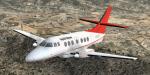
The Jetstream 32 is a twin turboprop and has been developped from the Jetstream 31 with a longer overhaul and more power. It has been launched in 1982 and 386 units have been produced. Original aircraft by PAD and J-P Brisard. Textures, adaptation to FSX, wide screen panel and VC by Philippe Wallaert. See instructions for installation in the readme.txt file. Credits: Premier Aircraft Design and J-P Brisard for the original model. Enjoy!
Posted Jan 15, 2013 03:23 by Philippe Wallaert
1.41Mb (515 downloads)
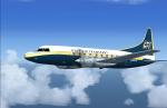
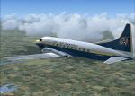
FS9/FSX Convair 580 Gulf Air Transport textures.
Requires Convair 580 aircraft by Greg Pepper.
Textures by Gary Harper
Posted Jan 15, 2013 00:17 by Gary Harper
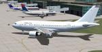
68.83Mb (12959 downloads)
Thomson Airways Boeing 767-300ER G-OBYG With Winglets and Enhanced VC.
Upgraded to FSX using Alejandro Rojas Lucena/FSND revised Boeing 737-800 VC. This model includes Working wipers (right mouse click on switch) with rain effect. Switches for LCD Screens, EICAS, PFD, MFT. Autobrake switch. Opening pilots window. Cabin Lights switch. Realistic FMC. Ground Proximity Warning System (GPWS), More Realistic night textures. Model features High resolution textures, Dynamic flexing wings, Body gear steering, Nose gear steering, Rudder lock, Ground spoilers, Low speed aileron locks at high speed, Fully animated control surfaces, Fully independent suspension, Trim Animation, Opening Passenger Doors, Cargo facilities (Use Posky Utility under FSX - Go to Views - Instrument Panel -Posky Utility) Animated tilting bogies, Rolling wheels, Animated thrust reverser's with reverser block doors, Detailed textures, Full night lighting, Crash affects, Ground Service Vehicles And more. Model Designer Hiroshi Igami. Flight Dynamics Designer Warren C. Daniel. Painted by: Carlos Eduardo Salas. FSX native model by Skyspirit/Project Opensky. VC by Alejandro Rojas Lucena (Alrot). Modified for FSX by Chris Evans.
Thank you to Carlos Eduardo Salas for professional textures and Project Opensky/Skyspirit for phenominal aircraft contributed as freeware!
Modified and assembled for FSX by Chris Evans.
Please read the VC docs to get the most out of this VC
Posted Jan 14, 2013 17:55 by Chris Evans
9.70Mb (1040 downloads)
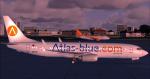
Atlas-blue textures for the default Boeing 737-800 FSX.
Posted Jan 13, 2013 09:47 by Jim Fly
24.76Mb (5489 downloads)
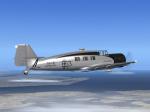
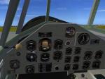
Ralf Kreibich's terriffic Junkers Ju-160, updated for FSX-Acceleration. All credits go to him!! I updated the panel.cfg (NO 2D-panel, only GPS, ADF and minipanel), great VC-panel. 3 Models, 5 liveries. All necessary gauges included (see original readme!!!!). Enjoy!
Posted Jan 13, 2013 04:48 by Erik Hertzberger
3.64Mb (1231 downloads)
FSX Airbus A310-222 repaint textures for the real world Delta N805PA in her
post-PanAm livery. For the Thomas Ruth A310-300, which you must have
previously installed in FSX. After aquiring PanAm's transatlantic system,
this simple Delta livery was used in order to quickly repaint PanAm's
airplanes. Screenshots enclosed. Easy installation. By Tom Tiedman.
Required files:
required file
Posted Jan 12, 2013 22:23 by Tom Tiedman