


FSX > Page 1170
3.89Mb (3779 downloads)
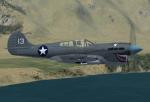
FSX/FSX Acceleration Curtiss P40K
The P-40K was the heaviest of the P-40 family.It served mainly in the Pacific theater and in China. It should have been the last model of the P-40 produced, but troubles with the P-60 program left production capacity available at the Curtiss factories, so the production of P-40s was continued despite the obvious weaknesses of the model.
GMAX mdl by A.F.Scrub
Posted Jan 6, 2013 16:03 by A.F.Scrub
6.58Mb (470 downloads)
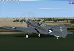
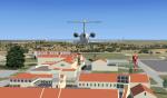
Textures only for the Milton Shupe De Havilland Canada Dash 7 package. This aircraft is used to fly Tourists on charter and schedule services domestically and to the National Parks. Requires file dash7pkgx.zip
Required files:
required file
Posted Jan 6, 2013 12:06 by Bashir Ismail
.jpg-thumb.jpg)
.jpg-thumb.jpg)
2.63Mb (1112 downloads)
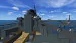
FSX features for FSX Features For Pilotable Landing Operation Carrier HMS Fearless or HMS Intrepid. A download of the ai-versions from Dave Garwood at Classic British Flight Sim is required. (please report links when broken to webmaster@simviation.com) My AddOn provides a pilotable ship with bridge, sounds and effects. Eight camera views let you explore the ship: F.i. standing at aa-guns or at the flight deck. Here you can place a Sealynx helicopter onto the deck. Or you can put a landing craft into the ships dock. Bitmaps and configuration by Erwin Welker
Posted Jan 6, 2013 07:35 by Erwin Welker
67.00Mb (7072 downloads)
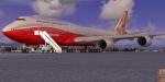
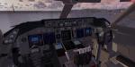
FSX SkySpirit2012 Boeing red roll out livery, registration N6067E.
Assembled and edited for FSX with the developed B747 VC from Alejandro Rojas Lucenda.
This is the Skyspirit FSX Boeing 747-8i model updated November 2012, and includes
ground cargo servicing, stairs (FSX - Go to Views - Instrument Panel -Posky Utility),
jetway (Ctrl J), opening cargo doors and more.
Included CF engine sounds from BrandonG, with realistic jet whine to make your flight
sound great.
Upgraded using the vastly improved Boeing 747 VC from Alejandro Rojas Lucena/FSND (See
panel docs for details). VC includes FMC, EICAS, MFD with control panel, GPWS, working
wipers, cabin lights, fire suppression, avionics switch, fuel crossfeed, landing
lights switches, taxi light switch, engine generators, APU generator, battery switch,
starter switches, de-ice switch, general lights switches.
Thank you to Skyspirit for their outstanding donations to the worldwide community of
flight simulation. Beautiful Boeing textures by Carlos Eduardo Salas.
Also includes the Boeing 747 VC textures upgrade. This give a much clearer 747
interior virtual cockpit look.
Assembled and edited for FSX by Chris Evans.
Zip preview for larger pictures.
See panel docs and images for VC details and controls
Posted Jan 6, 2013 06:39 by Chris Evans
8.98Mb (6562 downloads)
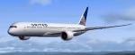
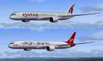
CamSim Boeing 787-9 V3. I've Painted 3 liveries for This Version 3 787, United, Virgin and Qatar. All latest liveries. Some have photo real parts. They feature an improved aircraft wing root design. Model design by Camil Valiquette. Repaints by Stephen Browning. Models have 2d panel but do not have VC.
Posted Jan 5, 2013 10:37 by Stephen Browning
5.59Mb (1608 downloads)
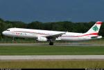
MEA textures for the default FSX Airbus A321.
Posted Jan 5, 2013 00:37 by Herz

12.29Mb (2235 downloads)
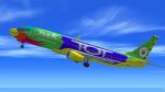
The airline was established in February 2004 beginning its first international service on 31 May 2007, with daily flights to Bangalore, India. Today Nok, (which is Thai for bird) has the highest number of domestic routes within Thailand, largely because Thai Airways International has failed to increase its share holding in Nok Air. This is a High Definition repaint for the default FSX Boeing 737-800 and is Textures only.
Posted Jan 4, 2013 15:51 by Paul Davies
5.52Mb (987 downloads)
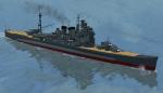
FSX features for the pilotable japanese WWII heavy cruiser Takao. The ship is a detailed CFS2-ai-ship from Usio No Ibuki. To get the FSX-converted version you have to download the beautiful scenery "chichi_jima_1945" from Tom Stovall and friends. My AddOn provides a pilotable ship with bridge, sounds and special effects. Ten camera views let you explore the ship. You can set an Aichi Jake floatplane onto the catapult. A "flight", approaching the japanese Fleet at the Chichi Jima-Atoll with your vessel is included. Panel and configuration by Erwin Welker.
Required files:
required file
Posted Jan 4, 2013 07:58 by Erwin Welker
4.79Mb (2548 downloads)
This the 1st edition of NAS Sigonella.
NAS Sigonella is one of the US Navy's prime bases overseas. Located on the east side of Sicily, it shares space with Italian armed forces. The stations first started in the area called Villaggio NATO (NAS I), as some maps show it. At first, the runway area was not a part of the initial facilities. Now days, the US Navy commands 3 areas which also include a housing area. Other branches of our services are tenants at the facilities. The base also provides strategic launching capabilites to NATO and US Allies.
Posted Jan 3, 2013 22:39 by Sam Sanders
5.20Mb (477 downloads)
Description:
This a texture only for payware VirtualCol Fokker 50.
Included Aircraft.cfg that has flight tuned to allow take off from short runway as in MPCH as the real bird does. (back up your current Aircraft.cfg)
Posted Jan 3, 2013 22:37 by Victor Pinto