


FSX > Page 1174
38.54Mb (2805 downloads)
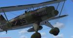
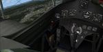
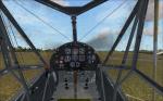
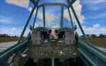
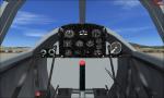
The Heinkel He 51 was a German single-seat biplane which was produced in a number of different versions. It was initially developed as a fighter, and a seaplane variant and a ground-attack version were also developed. It was a development of the earlier He 49.
Full animations, 3D gauges and Baked Textures. By Craig Richardson @ www.Classicwings.net. Many thanks to: Huub Vink (Textures), Tom Falley (Flight Model) and Mathias Pommerien for help on the 3d gauges and XML.
Posted Dec 29, 2012 09:12 by uploader
6.17Mb (3603 downloads)
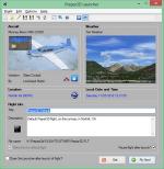
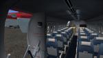
This application can be used as a launcher application for both FSX and Prepar3D. Flights can be loaded before launching the simulator or when the simulator is already running. New flight files can be created by selecting one of the installed aircraft, selecting the start location (runway or parking position), selecting the type of weather and the time of day.
Posted Dec 29, 2012 09:05 by uploader
25.94Mb (9720 downloads)
Tim Conrad's superb Fieseler Fi-156C Storch, now flyable in FSX with full working VC and other extra's. 2D-panel by Erwin Welker. All credits are for them! Seven different liveries, all necessary gauges included.
Posted Dec 29, 2012 05:20 by erik hertzberger
9.55Mb (5348 downloads)
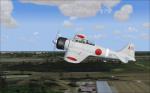
Great worn-out/battle damaged Microsoft's stock CFS2 Mitsubishi A6M2 Rei-sen (Zero/Zeke), updated for FSX. Full working VC, gun-effects for fun.
Posted Dec 28, 2012 17:31 by erik hertzberger
8.46Mb (1133 downloads)
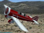
FSX/FS2004 Yakovlev Air-7 vintage racer
The "AIR-7", was a tandem-seat air racer / courier aircraft. It was inspired by contemporary American air racers such as early Granville Brothers (Gee Bee) machines and had a fair resemblance to them as a low-wing monoplane with landing gear in streamlined trouser fairings. It was powered by a Shvetsov M-22 nine-cylinder radial engine driving a two-bladed propeller. The M-22 was a copy of the British Bristol Jupiter radial, providing 360 kW (480 HP).
It was of mixed metal-wood construction and featured overwing struts, as well as bracing wires, to permit a lighter wing. The AIR-7 performed its initial flight on 19 November 1932 and quickly set a national speed record of 325 KPH (202 MPH).GMAX mdl by A.F.Scrub
Posted Dec 28, 2012 12:00 by A.F.Scrub
2.99Mb (1763 downloads)
FSX added views for the DHC Dash-7 from Milton Shupe. The cameras provide 4 external-, 3 cabin- and 4 cockpit-views. Configuration by Erwin Welker.
Required files:
required file
Posted Dec 27, 2012 13:04 by Erwin Welker
2.21Mb (412 downloads)
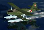
FS2004/FSX. This is a repaint in Polish Border Forces colours of Tim Conrad's wonderful AN-2V 'annushka' floatplane. These are textures only. Requires file AN-2VPPP.ZIP
Required files:
required file
Posted Dec 26, 2012 22:42 by Enrique Medal

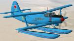
2.16Mb (406 downloads)
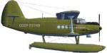
FS2004/FSX. This is a repaint in CCCP's Aeroflot colours of Tim Conrad's wonderful AN-2V 'annushka' floatplane. These are textures only, based in an old Aeroflot's colored postcard (I didn't find more pics of this aircraft). Requires file AN-2VPPP.ZIP
Required files:
required file
Posted Dec 26, 2012 20:01 by Enrique Medal
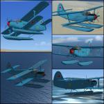
2.45Mb (425 downloads)
URSS Navy colours repaint for AN-2V Floatplane. FS2004/FSX. This is a repaint in URSS Navy colours of Tim Conrad's wonderful AN-2V 'annushka' floatplane.
These are textures only.
Required files:
required file
Posted Dec 25, 2012 22:29 by Enrique Medal
2.37Mb (613 downloads)
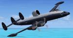
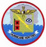
WC-121N Hurricane Hunter textures for Team 1049's FSX EC-121/WV-2 Updated Package. This is a repaint of a WV-2 as A/C# 143198 WC-121N of the VW-4 Squadron "Hurricane Hunters", NAS Jacksonville, Florida. 1960s era.
Required files:
required file
Posted Dec 25, 2012 06:26 by Michael E. Roberts