


FSX > Page 1172
9.27Mb (2575 downloads)
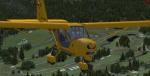
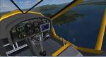
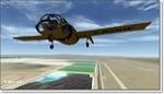
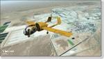
Aeroprakt A-22 Foxbat.
The A-22 'Foxbat' is available as a Ready-To-Fly factory built aircraft or as an advanced kit. Building time for the kit is 300 to 500hrs. Designed by former Antonov design engineer, Yuri Yakovlev , the A-22 is one of a line of many aircraft produced by Aeroprakt in the Ukraine. Construction is aluminium with some parts of the wing and control surfaces covered with Ceconite. The A-22 is powered by the reliable Rotax 912 or 912S engine, and the 3-blade composite ground adjustable propellor from KievProp is very quiet. A cabin width of 120cm (128cm at the elbows) ensures ample room for pilot and passenger. As a comparison, the cabin with of a Cessna 172 is 100cm and a Jabiru SP is 97cm (107cm at the elbows). Transparent doors with convex sides allow for excellent downward visibility. The instrument panel has room for a generous instrument layout. Dual controls are standard with options of either conventional control yokes or a centre stick. A centre stick with a "Y" grip is also available. Basic VFR flight and engine instruments are included with the ready-to-fly aircraft. A stall speed of 50kph (30mph) using the full span flapperons puts the A-22 safely into the microlight category. The all round visibility from the A-22 is spectacular. The aircraft has a baggage compartment that allows up to 20kg to be carried.
Posted Jan 2, 2013 13:57 by uploader
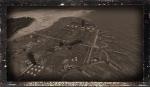
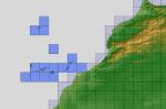
59.80Mb (984 downloads)
Photoreal coverage of Borax Open Pit Mine near Edwards AFB in California. Scenery includes blend masks, water masks, and night textures.
Posted Jan 2, 2013 02:41 by Chuck79
17.70Mb (443 downloads)
MPCH scenery for FSX.
Airport located in Changuinola, Bocas Del Toro, Panama
Posted Jan 2, 2013 01:27 by Victor Pinto
17.92Mb (4293 downloads)
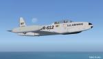
This is Tim Conrad's T-33 Updated For Flight Simulator X. Design work for the Lockheed P-80 began in 1943 with the first flight on 8 January 1944. Following on the Bell P-59, the P-80 became the first jet fighter to enter full squadron service in the United States Army Air Forces. As more advanced jets entered service, the F-80 took on another role - training jet pilots. The two-place T-33 jet was designed for training pilots to fly jets. This Aircraft belongs to the United States Air Force. This Aircraft has a new 2D and 3D fully functioning cockpits and new Effects. Textures and Updates by Mark " Fireball " Rooks of RDG Aircraft. Package Includes Pictures of the original TR-612 Aircraft Currently located In South Ga.
Posted Jan 1, 2013 00:27 by Mark Fireball Rooks
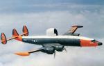
4.70Mb (1452 downloads)
EC-121K Pacific Missile Range Textures for Team 1049's FSX EC-121/WV-2 Updated Package. This is a repaint of a WV-2 as A/C# 137890 EC-121K of the Pacific Missile Range, Barking Sands, Hawaii. Late 1950s era.
Required files:
required file
Posted Dec 31, 2012 20:24 by Michael E. Roberts
78.43Mb (910 downloads)
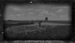
This scenery is of Truk Atoll depicting the time period during WWII.
The scenery includes the basic islands created from satellite images.
Also included are three airfields used by the Japanese and the naval base at Dublon.
Many effects are included along with sounds of the time.
This scenery is created by Tom Stovall. Many of the objects are used with the permission of Mark Schimmer and other contributors.
Posted Dec 31, 2012 20:01 by b
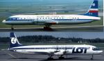

79.57Mb (6029 downloads)
Ilyushin Il-18 LOT (Polish Airlines) twin package, mid 70's and mid 80's liveries.
Using Edgar Giunart's great IL-18 with VC, Tested in Windows 7 Acceleration
SP1 SP2. Repaints by Stephen Browning
Posted Dec 31, 2012 10:11 by Stephen Browning

2.48Mb (2437 downloads)
FSX SP2 - A.I. Cessna 208B Grand Caravan - Regional Air Services Tanzania [ Parent company Air Kenya ] Complete Model
Posted Dec 31, 2012 10:05 by Repaint by Bashir Ismail
5.07Mb (2004 downloads)
"imp" means imperfect, as other mesh I have already processed is of areas that have very little vegetation cover - over the land, or has large urban areas.
This "imp" mesh will include some slight discrepancies of altitude (in the case of forested areas - by a magnitude sometimes of +15 metres-depending on how tall the trees are, in the jungle or forest canopy) over urban areas, or areas with a lot of vegetation cover - due to the limitations of the ASTER satellites infra red scanning cameras, and the software used to process the DEM data.
Areas where there is little vegetation cover, or non urban areas, the terrain should have truer values.
But I feel this ASTER DEM data is so good - why let it all go to waste - especially flying over lovely Pacific islands?
So you FSX users out there will have to take all this into account when using this mesh.
Grateful thanks to ERSDAC, and NASA for making this data freely available to the public.
ASTER GDEM
Copyright (c) 2009 - 2011 Earth Remote Sensing Data Analysis Center (ERSDAC) All rights reserved.
ASTER GDEM is a product of METI and NASA.
Posted Dec 31, 2012 09:57 by Wayne Evans
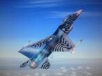
4.04Mb (1943 downloads)
Belgian Air Force Solo Display Team textures for Kirk Olssen's F-16 Viper. Textures by Mees Jansen. Requires original model adapted for FSX.
Required files:
required file
Posted Dec 31, 2012 07:19 by Mees Jansen