


FSX > Page 1171
5.64Mb (6209 downloads)
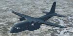
The CASA (now Airbus Military) CN-235 is a twin turboprop medium range transport aircraft. More than 250 units have been built since 1988. 2 liveries in this package: French Army and Moroccan Army. Original model and textures by J.E.Narcizo & RanchoJEN. French army textures, adaptation to FSX, original wide panel with GPWS callout and VC adaptation by Philippe Wallaert. See instructions in the readme.txt file. Credits: J.E.Narcizo & RanchoJEN for the original model. Nice flights!
Posted Dec 30, 2012 12:31 by Philippe Wallaert
68.03Mb (10579 downloads)
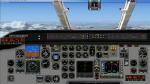
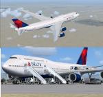
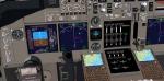
FSX Boeing 747-8i Delta Delux Package.
Assembled and edited for FSX with the developed B747 VC from Alejandro Rojas Lucenda. This is the Project Opensky FSX Boeing 747-8i model, and includes ground cargo servicing, stairs (FSX - Go to Views - Instrument Panel -Posky Utility), jetway (Ctrl J).
Included CF engine sounds from BrandonG, with realistic jet whine to make your flight sound great.
Upgraded using the vastly improved Boeing 747 VC from Alejandro Rojas Lucena/FSND (See panel docs for details). VC includes FMC, EICAS, MFD with control panel, GPWS, working wipers, cabin lights, fire suppression, avionics switch, fuel crossfeed, landing lights switches, taxi light switch, engine generators, APU generator, battery switch, starter switches, de-ice switch, general lights switches.
Thank you to Skyspirit for their outstanding donations to the worldwide community of flight simulation. Professional Delta textures by Gabriel Guzman.
Also includes the Boeing 747 VC textures upgrade. This give a much clearer 747 interior virtual cockpit look.
Assembled and edited for FSX by Chris Evans.
Zip preview for larger pictures.
See panel docs and images for VC details and controls
Posted Dec 30, 2012 04:59 by chris evans
8.33Mb (4038 downloads)
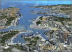
An all new landclass and accurate coastline scenery of the Maltese Islands compatible with FSX only.
It also includes some static generic scenery to highlight certain prominent areas around the islands such as the Grand Harbour, Freeport, plus more.
If you own Malta Intl Airport v2, only Malta XGen v1.2 is required.
Posted Dec 30, 2012 01:18 by Ryan Speakman
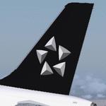
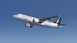
16.69Mb (2380 downloads)
Shenzhen Airlines Airbus A320-214 Star Alliance for Flight Simulator X. Aircraft model and texture of B-6296 are included, along with panel, sound & virtual cockpit from the default A321. Original aircraft by Project Airbus, texture by Lingyuan He from China. Note: This package can be used in FS9, please read the instructions inside the package.
Posted Dec 29, 2012 23:37 by Lingyuan He
39.29Mb (2191 downloads)
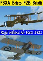
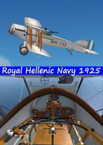
FSX Acceleration Bristol F2B Greek Tourer RHN/RHAF complete package with twin Livery of 1925 Royal Hellenic Navy(All Silver) and 1931 Royal Hellenic Air Force (Dark Green). The superb model by Robert Bruce features detailed virtual cockpit animated pilots and sound. As usual I have included all historical info and photos in the package. The 2 liveries resemble the 81A type(Greek tourer). Textures in DDSx32 bit format(FSX only) by Hellenic Aircraft/Yiannis Katehis Tsetsas
Posted Dec 29, 2012 12:48 by YIANNIS KATEHIS TSETSAS
1.69Mb (1394 downloads)
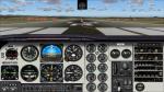
FSX/FS2004 Beech B58 Baron Widescreen Panel. 2D widescreen panel to be used with any default Beechcraft Baron B-58 or similar aircraft. This panel is made for high definition 1920 x 1080 pixels. By Jacques Vallcaneras.
Posted Dec 29, 2012 11:50 by Jacques VALLCANERAS
13.32Mb (2112 downloads)
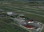
Scenery of Chambley-Bussieres (France). Former AFBase LF52, now LFJY. Home of the "Ailes Mosellanes" aero-club. Photorealistic ground texture with seasonnal effects. Includes 80 custom models and 500 library objects, static planes, cars, animated flags and windsocks, vehicles, peoples, birds, etc. VAC chart included. Works with FSX and FSXA. By D. Bur
Posted Dec 29, 2012 09:18 by uploader
38.54Mb (2801 downloads)
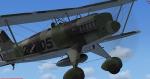
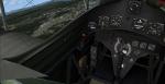
The Heinkel He 51 was a German single-seat biplane which was produced in a number of different versions. It was initially developed as a fighter, and a seaplane variant and a ground-attack version were also developed. It was a development of the earlier He 49.
Full animations, 3D gauges and Baked Textures. By Craig Richardson @ www.Classicwings.net. Many thanks to: Huub Vink (Textures), Tom Falley (Flight Model) and Mathias Pommerien for help on the 3d gauges and XML.
Posted Dec 29, 2012 09:12 by uploader
6.17Mb (3603 downloads)
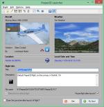
This application can be used as a launcher application for both FSX and Prepar3D. Flights can be loaded before launching the simulator or when the simulator is already running. New flight files can be created by selecting one of the installed aircraft, selecting the start location (runway or parking position), selecting the type of weather and the time of day.
Posted Dec 29, 2012 09:05 by uploader
25.94Mb (9713 downloads)
Tim Conrad's superb Fieseler Fi-156C Storch, now flyable in FSX with full working VC and other extra's. 2D-panel by Erwin Welker. All credits are for them! Seven different liveries, all necessary gauges included.
Posted Dec 29, 2012 05:20 by erik hertzberger