


FSX > Page 1180
21.46Mb (1915 downloads)
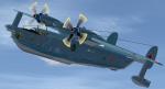
I updated the Beriev BE-12 by Vladimir Zhyhulskiy. By adding the FS2002/FS2004 Beriev BE12 Panel by Steve Boston, that I re-gauged with Russian gauges from Vladimir Zhyhulskiy's An-12, Brett Hosnins' 3MS Bison and Philippe Wallaert's An-124 panels. I also included the the water bombing fire fighter texture by Steve Boston and texture thumbnails for both textures. 2D panel only, no VC panel.
Posted Dec 10, 2012 06:44 by Michael E. Roberts
63.43Mb (2325 downloads)
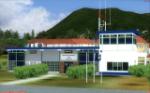
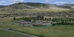
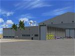
Photoreal model of terminal, tower and PIR in the
Photo_scenery of St.Eustatius (Statia) in the Caribbean, with the airport F.D. Roosevelt (TNCE)in Oranjestad. This replaces previous St Eustatius uploads and includes updates and mesh.
Required files:
required file
Posted Dec 9, 2012 19:35 by Harald Sandvik
32.36Mb (6522 downloads)
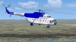
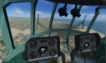
AeroGaviota Mil Mi-8 helicopter with simple but functioning virtual cockpit (VC). AeroGaviota is a passenger charter airline based in Havana, Cuba at the Playa Baracoa Airport. They operate tourist/scenic flights using their several Russian Mi-8 helicopters. Textures by kilocharlie1. Model by V. Zhyhulskiy.
Posted Dec 9, 2012 02:22 by kilocharlie1
16.26Mb (1780 downloads)
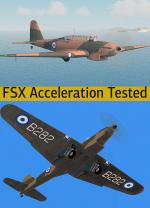
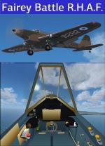
FSX Acceleration Fairey Battle MK I RHAF package.The Hellenic Royal Air Force Received 11 Fairey Battle at March of 1940 that where enlisted at the 33rd Bomber Sq. and took part in the Greek-Italian War. They had roundels on the under side of the wing and on the fuseladge. All of them where destroyed in mid air or on the ground during the conflict. In Greece they had a crew of three. The credit for the excellent model goes to Edward Cook. There was a problem with the gauges call in FSX and its now fixed. Full VC, two different panels to choose from, effects, sound, historical info and photos. Modifications and repaint for the Hellenic colors by Hellenic Aircraft/Yiannis Katehis Tsetsas.
Posted Dec 8, 2012 22:42 by YIANNIS KATEHIS TSETSAS
7.06Mb (1079 downloads)
Queenstown is a small GA airfield in South Africa's Eastern Cape region. FSX Acceleration will give the best results.(Also SP2 compatable). Acceleration users will have more eye candy!
Posted Dec 8, 2012 10:06 by Jacques Botha
24.08Mb (4455 downloads)
I updated By Robert Versluys and Gustavo La Cruz's Sukhoi 80 RA82911 for Fs2004/FS9 by modifying the CAMSIM Aviation Simulation 787 panel using real photos courtesy of Sukhoi {United Aircraft Corporation (KnAAPO)} also included. I used metric gauges from Bill Wolfgen's Russian gauges and Il-96 gauges, Vladimir Zhyhulskiy's An-12 autopilot and Dennis Seeley Gauges for the Be-200. I also gave it texture thumbnails and Benny Miller's Saab 340 Sound set. Includes two models , one with working rear ramp and one without. No VC Panel.
Posted Dec 8, 2012 04:43 by Michael E. Roberts
32.85Mb (6290 downloads)
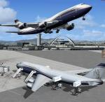
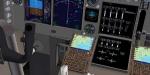
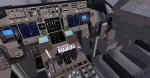
Boeing 747-8i Boeing Business Jets (BBJ) with advanced VC
Assembled and edited for FSX with the developed B747 VC from Alejandro Rojas Lucenda. This is the Project Opesnky native FSX model, including ground servicing, stairs (FSX - Go to Views - Instrument Panel -Posky Utility), jetway (Ctrl J)
Upgraded using the vastly improved Boeing 747 VC from Alejandro Rojas Lucena/FSND (See panel docs for details). VC includes FMC, EICAS, MFD with control panel, GPWS, working wipers, cabin lights, fire suppression, avionics switch, fuel crossfeed, landing lights switches, taxi light switch, engine generators, APU generator, battery switch, starter switches, de-ice switch, general lights switches.
Thank you to Skyspirit/Proje3ct Opensky for their outstanding donations to the worldwide community of flight simulation. BBJ textures created by Alexi Antoniou.
Also includes the Boeing 747 VC textures upgrade. This give a much clearer 747 interior virtual cockpit look.
Assembled and edited for FSX by Chris Evans.
Zip preview for larger pictures.
See panel docs and images for VC details and controls
Posted Dec 7, 2012 08:42 by Chris Evans
30.85Mb (23428 downloads)
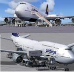
SkySpirit 2012 Boeing 747-840i Lufthansa D-ABYA with advanced VC and more. D-ABYA is the 1st delivery of the new Boeing 747-8 Intercontinental. This is the 2012 Skyspirit Boeing 747-800i model, updated November 2012, including ground servicing, stairs (FSX - Go to Views - Instrument Panel -Posky Utility), jetway (Ctrl J). Upgraded using the vastly improved Boeing 747 VC from Alejandro Rojas Lucena/FSND (See panel docs for details). VC includes FMC, EICAS, MFD with control panel, GPWS, working wipers, cabin lights, fire suppression, avionics switch, fuel crossfeed, landing lights switches, taxi light switch, engine generators, APU generator, battery switch, starter switches, de-ice switch, general lights switches. Thank you to Skyspirit for their outstanding donations to the worldwide community of flight simulation. Lufthansa textures created by Ryan C. Also includes the Boeing 747 VC textures upgrade. This give a much clearer 747 interior virtual cockpit look. Assembled and edited for FSX by Chris Evans. Zip preview for larger pictures.
Posted Dec 7, 2012 08:00 by Chris Evans
6.16Mb (938 downloads)
Hawes Aerial Operations Facility is a reimagined version of an abandoned World War II auxiliary airstrip formerly known as Hawes AAF Aux #1. It was built in the mojave desert, just east of Edwards AFB (then Muroc AAF) during WWII as one of 4 satellite fields for Victorville AAF. After the war, Hawes as used as a private civilian airfield until it's closure in the early 1960's. It is now reborn in FSX as a UAV base by Nevada Systems. Due to it's location in the Mojave desert and the presence of many thermals in FSX, it was also used in production of the Aeroworks ARX-1 civilian glider concept. This scenery uses many custom macros as well as default macros from the Acceleration Expansion Pack, which is required for best performance. Scenery and custom macros by Joshua B. Nyhus and Jason L. Terry
Posted Dec 7, 2012 06:53 by Jason Terry
14.37Mb (2221 downloads)
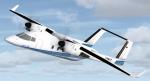
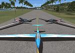
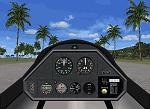
The ARX-1 is a single seat sailplane concept in both unpowered (A model) and powered versions (B model). Both glider models make use of the variometer to detect thermals for soaring in FSX. The Concept 1 was our first concept plane, released in 2000 for FS7. The ARX-1 was originally designed after RC gliders, with basic technology from the default FS2000 Schweizer. So it does not have negative flaps, water ballast, or retractable gear. As our first Concept, it is purposely built to be incredibly simple, reliable, docile, and mildy aerobatic and features a forward fuselage and cockpit section identical to it's much smaller and faster cousin, the ARX-6 Formula One pylon air racer. This package includes 11 aircraft in 2 different models with 12 schemes. By Jason L. Terry and Brady Duros.
Posted Dec 7, 2012 06:47 by Jason Terry