


FSX > Page 1183
5.25Mb (3024 downloads)
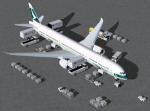
FSX Cathy Pacific Boeing 787-10 v4. This CamSim version 4 features an improved aircraft wing root design,
new wider pax doors with revised window shapes, additional animated air ducts, additional comm and satellite antennas,
increasingly more Animated Ground Servicing (AGS), including additional animations featuring trucks hooking and unhooking trailers and static displays.
Model design and paint by Camil Valiquette. 2d panel but no VC.
Posted Nov 30, 2012 21:29 by Camil Valiquette
27.20Mb (1913 downloads)
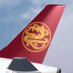
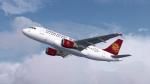
Juneyao Airlines Airbus A320 Series for Flight Simulator X. Aircraft models and texture of B-6232 (A319-112) and B-6670 (A320-214) are included, along with panel, sound & virtual cockpit from the default A321. Original aircraft by Project Airbus, texture by Lingyuan He from China. Note: The texture can be used for FS9 version of A319 and A320(V2.1).
Posted Nov 30, 2012 21:14 by Lingyuan He
79.38Mb (5316 downloads)
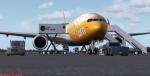
Boeing 777-200ER Scoot Airlines package with new revised VC/panel including FMC. (Find it under Views-Instrument Panel) Features are Opening doors & Cargo doors, detailed textures, accurate paint, dynamic shine & effects, dynamic flexing wings that respond to turbulence, fully independent suspension, trim animation, gear steering, accurate flight dynamics, spoiler animation, reflective cockpit windows, crash effects, animated tilting bogies, full night lighting, ground service vehicles when cargo door open, (FSX - Go to Views - Instrument Panel -Posky Utility), detailed virtual cockpit and more. See docs for FMC details and info.
Posted Nov 30, 2012 09:34 by Isaac Tan
57.70Mb (11406 downloads)
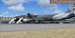
Air New Zealand Boeing 777-319/ER Registration "ZK-OKQ" All Blacks. Includes revised
VC and FMC (via Views-Instrument panel). Model features are Opening doors & Cargo
doors, detailed textures, accurate paint, dynamic shine & effects, dynamic flexing
wings that respond to turbulence, fully independent suspension, trim animation, gear
steering, accurate flight dynamics, spoiler animation, reflective cockpit windows,
crash effects, animated tilting bogies, full night lighting, ground service vehicles
when cargo
door open, (FSX - Go to Views - Instrument Panel -Posky Utility), detailed virtual
cockpit and more. Model, VC model by Project Opensky and professionally textured by
Carlos Eduardo Salas. Mods for FSX by Chris Evans. See FMC docs.
Posted Nov 30, 2012 09:30 by Chris Evans
398.83Mb (2678 downloads)
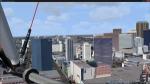
FSX Scenery includes buildings for the downtown,
Balboa Park, and Little Italy areas.
Designed for use with Megascenery.
Tested with Glenn Johnson's KSAN.
By Brian N. Winton
Posted Nov 29, 2012 11:09 by uploader

1.96Mb (1110 downloads)
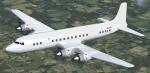
FSX Douglas DC-7C real world PH-DSL in her final white livery. Repaint textures
for the Gibson-Follas DC-7C which I enjoy flying in FSX. I installed her using
the Philippe Wallaert Alitalia with VC upgrade "Douglas_DC7.zip" (available here)
with good results. Last seen at London-Stansted dressed in heavenly white and
sitting on the burn pile awaiting firefighter training, real world PH-DSL,
having previously worn the colors of KLM and Martinair, and for some time even
having enjoyed the sweet life of flying in Biafra, proclaims "not today,
firefighters"! Escaping to FSX, she rises from the ashes, her glorious white
livery washed and polished and highlighted against a beautiful blue sky, to once
again ply her trade on countless flight sim monitors scattered across the globe!
Includes engine smoke coordinates adjusted for FSX. Screenshots enclosed.
Easy installation. By Tom Tiedman
Required files:
required file
Posted Nov 27, 2012 23:39 by Tom Tiedman

8.57Mb (2683 downloads)
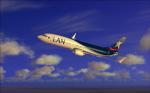
LAN textures for the default FSX Boeing 737-800. Repainted by Maxi Salas
Posted Nov 27, 2012 10:01 by Maxi Salas
44.86Mb (2504 downloads)
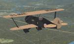
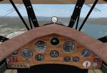
The package includes the Golden Age Simulations CTO models represented as the Northwest Airways WACO fleet being operated as an airmail service in 1929-1936. The staff consists of a historical fleet (in two configurations - with or without engine jacket and landing gear pants), powered by 330 hp Wright R-975E engine and a pack of two airworthy survivors with 365 hp R-975E-1. Apart the original models and basic texture the package also includes all necessary liveries and two new VC panels. Paints and modifications by Vladimir Gonchar
Posted Nov 26, 2012 22:06 by Vladimir Gonchar
1.46Mb (1669 downloads)
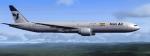
Boeing 777-300ER IranAir textures for the Skyspirit Boeing 777-300ER
Required files:
required file
Posted Nov 26, 2012 19:19 by Amirhossein Tarmast
2.14Mb (3599 downloads)
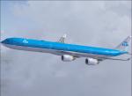
Fictional textures for Thomas Ruth's Airbus A340-600 in KLM livery. Original plane uploaded by T.Marson.
Required files:
required file
Posted Nov 26, 2012 17:58 by Lars