


FSX > Page 1182
7.85Mb (1254 downloads)
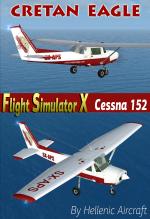
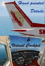
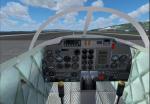
The Cessna C152 SX-APS is owned and operated by Cretan Eagle Aviation,a pilot school Located at IraKlion Nikos Kazantzakis Int.Airport at The Isle of Creta in Greece for training new pilots. The Superb Model is an X Just Flight payware now available for free download.(Follow link below to download it). After Using the usual photoreal technique the tail logos were all hand drafted to ensure quality and integrity of colors. I have left the texture files in a simple bitmap mode so they can be used in both FSX and FS2004. Special thanks to Flying instructor Cpt.Konstantinos Savides of Cretan Eagle Aviation for providing the photo material. There are photos of the actual aircraft in the file. Repaint for the Hellenic Colors by:Hellenic Aircraft/Yiannis Katehis Tsetsas 2012.
Required files:
required file
Posted Dec 3, 2012 19:31 by YIANNIS KATEHIS TSETSAS
0.01Mb (579 downloads)
A small fix for PZL AN28 that changes a flight model to make it more realistic. It also adds a co-pilot view.
Required files:
required file
Posted Dec 3, 2012 19:04 by Intruder
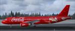

31.05Mb (7086 downloads)
Project Airbus A320 CocaCola Christmas livery for FSX.
Includes default VC, upgraded by Jim Fly.
You can find this aircraft under 'Project Airbus' in your FSX menu.
Repaint by Jim Fly
Posted Dec 3, 2012 13:29 by Jim Fly

9.83Mb (3792 downloads)
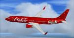
Coca Cola Christmas textures for the default B737-800 FSX.
Posted Dec 3, 2012 13:19 by Jim Fly
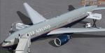
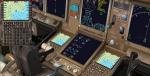
78.14Mb (8768 downloads)
Boeing 777-200/ER United Airlines Battleship livery N228UA with new VC and FMC. N228UA was the last
battleship grey revenue flight by UAL from Heathrow to LAX in Feb 2012. Includes
revised VC and FMC (via Views-Instrument panel). Model features are Opening doors &
Cargo doors, detailed textures, accurate paint, dynamic shine & effects, dynamic
flexing wings that respond to turbulence, fully independent suspension, trim
animation, gear steering, accurate flight dynamics, spoiler animation, reflective
cockpit windows, crash effects, animated tilting bogies, full night lighting, ground
service vehicles when cargo
door open, (FSX - Go to Views - Instrument Panel -Posky Utility), detailed virtual
cockpit and more. Model, VC model by Project Opensky and professionally textured by
Gabriel Guzman. Mods for FSX by Chris Evans. See FMC docs.
Posted Dec 3, 2012 09:52 by Chris Evans
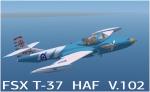
19.59Mb (3903 downloads)
This is the FSX Acceleration Version 1.02 of the HAF T-37 Mistras. The Gauges and configuration will work on FSX Acceleration only so, for Fs2004/FS9, you should download my previous version. This is also a complete package. There is an alternative VC and 2d panel with modified gauges, different sound and a more accurate air file and configuration. Photoreal textures, animated parts and flame effects. Model BY Capt. I. D'Attomo and Capt. G.Quai.Modifications and repaint for FSX by: Hellenic Aircraft/Yiannis Katehis Tsetsas
Posted Dec 3, 2012 04:28 by YIANNIS KATEHIS TSETSAS
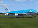
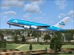
46.43Mb (12283 downloads)
Airbus A380 KLM package.
Project Airbus A380 with Thomas Ruth A340 virtual cockpit painted in KLM livery.
Textures by Peter Franeker.
Posted Dec 1, 2012 10:47 by Peter Franeker
0.08Mb (4595 downloads)
This fixes the missing sound for the FS9 Alphasim B-52 converted to FSX.
Required files:
required file
Posted Dec 1, 2012 09:23 by Steve Hess
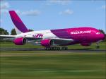
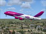
45.94Mb (4319 downloads)
Airbus A380 Wizz Air
Project Airbus A380 with Thomas Ruth A340 virtual cockpit. Painted in Wizz air livery.
Textures by Peter Franeker.
Posted Dec 1, 2012 07:42 by Peter Franeker
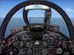
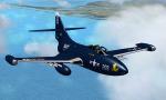
1.74Mb (3173 downloads)
Aeroplane Heaven's Grumman F9F Panther is flyable in FSX but the instrument panel contained many old gauges that only worked in FS9 or earlier versions. This modification uses default FSX gauges where necessary. There is some minor tweaking of the panel background but I have attempted to maintain the "old school" appearance of the original panel. Updated by R.E. Wyman.
Required files:
required file
Posted Dec 1, 2012 01:06 by R.E. Wyman