


FSX > Page 1185
62.61Mb (13030 downloads)
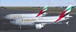
Thomas Ruth A310-300 Emirates Package for FSX
Two A310 Emirates, A6-EKL and
A6-EFB SkyCargo.Includes VC.
Repaint by Jim Fly
Posted Nov 24, 2012 19:20 by Jim Fly
9.29Mb (5222 downloads)
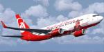
Air Berlin Boeing 737-800WL, registration D-ABMJ in special 'Flying home for Christmas'/ 'Santa Claus Tour 2012' colours. Now also with 'airberlin.com' on belly. Highly detailed 32 bit textures with alpha channel. Photorealistic window textures and sky interior-night textures. Complete model by Project Open Sky (Posky) with default B737-800 VC are included. By Benjamin Spranger / FSRepaintsGER.
Posted Nov 24, 2012 13:01 by Benjamin Spranger / FSRepaintsGER
4.05Mb (2433 downloads)
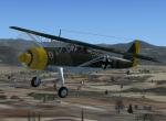
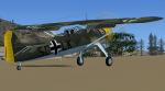
FSX/FS2004 Henschel HS126
The Henschel Hs 126 was a German two-seat reconnaissance and observation aircraft of World War II.The Hs 126 was well received for its good short takeoff and low-speed characteristics which were needed at the time. It was one of the most important aircraft in the early years of the war as a short-range reconnaissance aircraft, but was soon superseded by the general-purpose, STOL Fieseler Fi 156 Storch and the medium-range Focke-Wulf Fw 189. GMAX mdl by A.F.Scrub
Posted Nov 24, 2012 10:55 by A.F.Scrub
0.01Mb (2699 downloads)
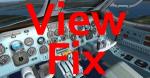
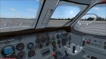
PZL AN-28 package views fix and FAQ's. This will fix the viewpoint for those that cannot see the VC. Also answers to questions. Just replace the aircraft.cfg with this one.
Posted Nov 24, 2012 07:06 by uploader
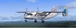
205.76Mb (13367 downloads)
The PZL An-28 is a polish version of an Antonov An-28 built under licence in PZL Mielec. More than 200 units of this turboprop have been constructed since mid 80's. Original model for X-Plane by Vadim Duplishev. Conversion, modification, animations, some liveries and xml coding by Intruder. Credits: Vadim Duplishev for the original model. See instructions for installation and troubleshooting in readme. This is the whole aircraft in BETA stage, including clickable VC, rain and icing effect, 48-pages manual and checklists as well. You need 590MB free HDD space for installation. Enjoy!
Posted Nov 24, 2012 04:01 by Intruder
0.40Mb (2163 downloads)
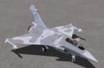
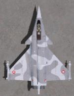
This package contains 2 sets of camera views ( defined by camera definitions in the aircraft.cfg file ) for
the beautiful Rafale A, C and M models by Cyril Pioffet. Gauges by Eric Marciano.
Updated for FSX By Anthony Douglas and Vladyslav Pavlyuk. Requires the "Dassault Rafale M package".
Version 1.1 - Cameras are located at about the same level of the aircraft.
Version 2.0 - based on version 1.1 but some of the cameras are placed at a higher level.
These two sets fit all three models ( A, C, M ). The 5 folders created when unzipping can be
reduced to one with careful planning.
10 cameras pointing at the aircraft - including a new "Top-down" zoomable view.
Total of 3 VC cams including 2 new "Over the shoulder" views.
See Read me.txt file for very easy installation procedures.
Camera definitions sets are included in 2 separate text files.
Available.pdf and Top 20.pdf for informations about my "camera definitions" packages.
about my "camera definitions" packages.
Enjoy !
Required files:
required file
Posted Nov 24, 2012 00:28 by Marc Renaud
2.55Mb (2964 downloads)
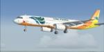
Airbus A321 Cebu Pacific textures for the default FSX A321
Posted Nov 24, 2012 00:25 by george
8.32Mb (1392 downloads)
This is the expansion pack of 20 additional schemes for the Aeroworks Concept 5 and requires the original aircraft available here. The ARX-5X is a single-seat unlimited category aerobatic aircraft built around the 495c.i. 600hp Trace-Orenda OE600 V-8 aircraft engine and
designed specifically for freestyle airshow type aerobatics. The expansion includes 12 domestic US schemes, and 8 international versions in the colors
of England, Italy, Japan, Switzerland, Brazil, and Finland. By Jason L. Terry.
Required files:
required file
Posted Nov 23, 2012 22:02 by Jason L. Terry
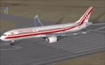
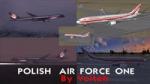
3.89Mb (830 downloads)
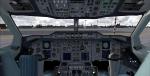
Abacus Polish Air Force One textures for the payware Abacus 787 Dreamliner
Posted Nov 23, 2012 12:28 by Voiteh
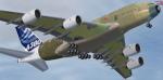
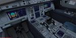
29.50Mb (8220 downloads)
Project Airbus A380-841 Airbus Industrie F-WXXL Primer
Edited for FSX with VC by Michael Litze.
Credits
Model: Project Airbus.
VC model: Thomas Ruth.
Textures: Mathieu Vos
Posted Nov 23, 2012 12:14 by michael litze