


FSX > Page 1188


1.32Mb (3301 downloads)
Replacement VC lighting for the FSX Lear 45, to make night flying more enjoyable.
The default dome lighting was far too bright so this has been brought down to a realistic level. In addition to this most of the display lighting has been replaced with a blue/white LED style including a small glow effect. The overall mod means you can now enjoy night flying and the instrument lighting. Check out the before and after pictures in the
File info
Posted Nov 19, 2012 17:57 by Paul Davies


3.36Mb (5314 downloads)
Replacement VC lighting for the FSX Bombardier CRJ-700, to make night flying more enjoyable.
The default dome lighting was far too bright so this has been brought down to a realistic level. In addition to this most of the display lighting has been replaced with a blue/white LED style including a small glow effect. The overall mod means you can now enjoy night flying and the instrument lighting. Check out the before and after pictures in the
File info
Posted Nov 19, 2012 17:55 by Paul Davies

3.49Mb (10642 downloads)
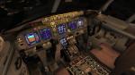
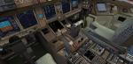
Replacement VC lighting for the FSX 737-800, to make night flying more enjoyable.
The default dome lighting was far too bright so this has been brought down to a realistic level. In addition to this most of the display lighting has been replaced with a blue/white LED style including a small glow effect. The overall mod means you can now enjoy night flying and the instrument lighting. Check out the before and after pictures in the File info.
Posted Nov 19, 2012 15:40 by Paul Davies
0.28Mb (5439 downloads)
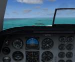
the year is 1985 and your job is to fly with your family for a vacation to Key West, Florida, U.S.A.!
Posted Nov 19, 2012 11:18 by Mr. Pierre Shlimon
32.27Mb (7228 downloads)
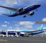
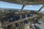
Boeing 777-200LR Worldliner (aka Dreamliner) Livery - N6066Z with Virtual Cockpit for FSX
Boeing 777-200/LR Worldliner N6066Z Painted on SkySpirit2012 Boeing 777-200/LR aircraft. The textures are saved in 32bit format for quality graphics. Its features are Opening doors & Cargo doors, detailed textures, accurate paint, dynamic shine & effects, dynamic flexing wings that respond to turbulence, fully independent suspension, trim animation, gear steering, accurate flight dynamics, spoiler animation, reflective cockpit windows, crash effects, animated tilting bogies, full night lighting, ground service vehicles when cargo
door open, (FSX - Go to Views - Instrument Panel -Posky Utility), detailed virtual cockpit and more. Model, VC model and textures by Project Opensky. Minor mods for FSX by Chris Evans.
Posted Nov 19, 2012 10:40 by Chris Evans
64.80Mb (13925 downloads)
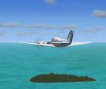
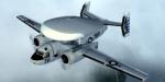
Functional VC model included; Package includes one beautifully crafted exterior livery, a great flight model, authentic custom radial sounds, and custom panels with aircraft specific gauges, and easy-to-read clickable virtual cockpits. FSX native upgrade by Eagle Rotorcraft Simulations This aircraft release is one of 7 aircraft in a series that will be released. FSX Only. DirectX 10 compatible.
Posted Nov 18, 2012 02:04 by Milton Shupe, George Arana, Brandon Filer, Sim-Outhouse
0.29Mb (1172 downloads)
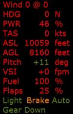
TextInfo Gauge provides an on-screen text display of real-time flight data, indicators and warnings. It is a simple XML file that is easy to modify. Display size is a single setting in the panel.cfg file. V2.0 uses less screen space, has improved screen clarity and adds some features. It includes installation instructions and a detailed explanation of the various elements of the XML script (calculating percentages, conditional data displays, formatting, etc.). It also includes info about panel.cfg files. By Rick Federmann (Pville211)
Posted Nov 18, 2012 00:14 by Pville211
68.66Mb (6973 downloads)
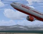
The new Air India Boeing 777-300ER GE, textures dds HD with new lights. Can carry 451 passengers in 2 class with a range of 7,930 nmi(14,690 km) at 43,100 ft (13,140 m) in Mach 0.86. Model by SMS and texture by ricardo_tv.
Posted Nov 17, 2012 22:37 by ricardo_tv
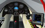
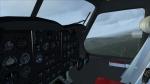
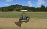
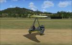
16.95Mb (2870 downloads)
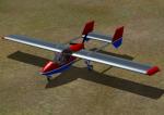
This is the complete Sadler Vampire that was created by Byron Warwick, updated so that the gauges and GPS are functional in FSX. Also includes new a new red, white and blue paint scheme. Update and repaint by Rick Federmann (Pville211)
Posted Nov 17, 2012 16:48 by Pville211
0.62Mb (1065 downloads)
Hi!
This is my first attempt at a treasure hunt style mission. I'm not sure how good it is really! Sorry!
Anyway it is set in a thermal spa town called Baden-Baden in Germany in the year 1997. You don't really look for treasure either you just have to try and find some places on the included map.
Posted Nov 17, 2012 14:58 by Mr. Pierre Shlimon