


FSX > Page 1186
24.67Mb (2201 downloads)
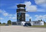
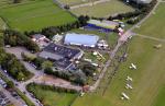
This is Pease AFB, NH. as it was in the late '70s when it was the 509th Strategic Air Command base. Aircraft stationed at Pease AFB were the FB-111A mach 2+ swing-wing bombers, KC-135 refueling tankers and the T-37 trainers.
New for version 3.0
*New AI FB-111A aircraft now take-off with the wings forward. When parked and engines are off the elevons droop and the ladders & remove before flight flags appear. Other features include afterburners, working spoiler brakes and a custom repaint for Pease AFB scenery
*Improved frame rates
Other features included in this scenery package are:
*Parking spots for Military Combat and Cargo aircraft.
*Ground support equipment and vehicles
*AI FB-111A , KC-135, and T-37 aircraft and flight plans
*AI FB-111A's that ATC addresses by tail number.
*Custom Textures and for each AI FB-111A
*Custom created static FB-111A and KC-135 aircraft
*Custom buildings included Hangers, Control Tower and Alert Bunker
*Hangers and tower have night lighting and static aircraft with night textures.
*Alert Area with shelters and static FB-111A with SRAMs and KC-135 aircraft
*Custom signs and flags.
*Individual add on transient aircraft and flight plan packages to save frame rates
*AI fighter aircraft have afterburners
*Pole mounted lights illuminate flightline. Previous version had 3728 downloads.
Posted Nov 23, 2012 11:57 by Steve Hess and Guy Diotte
2.96Mb (484 downloads)
Improved Nogales Scenery for Nogales, Arizona, USA
Posted Nov 23, 2012 11:54 by Andrew Johnson

27.65Mb (3586 downloads)
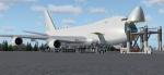
Project Opensky - Boeing 747-400F 747_4HQF LoadAir Cargo package with advanced VC
Assembled and edited for FSX with Enhanced VC from Alejandro Rojas Lucenda. Package
assembled and edits by Chris Evans. Thank you to Skyspirit for their wonderful models.
Loadair repaint by Project Opensky team member. Painted with the Boeing factory all white
livery, it was registered as 9K-DAA, later change to N5022E and finally registered as
N452BA, this brand new freighter operates for LoadAir Cargo. Also this is one of the
last 744F built in Paine Field.
Skyspirit FSX native Boeing 747-400 model upgraded using the vastly improved Boeing
747 VC from Alejandro Rojas Lucena/FSND (See panel docs for details). VC includes FMC,
EICAS, MFD with control panel, GPWS, working wipers, cabin lights, fire suppression,
avionics switch, fuel crossfeed, landing lights switches, taxi light switch, engine
generators, APU generator, battery switch, starter switches, de-ice switch, general
lights switches. Beautiful Skyspirit 747-800 cargo model with complex features and
ground service vehicles (press shift e 2, shift e 3, etc. ). To use jetway press Ctrl
J.
Also includes the Boeing 747 VC textures upgrade by Jason A. Lee. This give a much
clearer 747 interior virtual cockpit look. Loadair textures by Xudeva Irribarra.
See docs for VC details.
Assembled and edited for FSX by Chris Evans.
Posted Nov 23, 2012 09:50 by Chris Evans
2.25Mb (602 downloads)
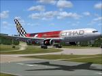
Ethiad F1 textures for the payware Level D Boeing 767-300.
Textures by Peter Franeker.
Posted Nov 23, 2012 01:44 by Peter Franeker
60.50Mb (8219 downloads)
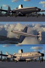
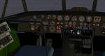
Lockheed Constellation for FSX
Alphasim FS9 Lockheed Constellation set modified for FSX with added gauges into the VC and 2d panel. Multi liveries and models: Lufthansa, BOAC, TWA, USAF EC-121R, US Navy EC121K Warning Star, USAF RC121D Warning Star.
This is an old FS9 model with simple VC but it is still a nice model to fly and to look at.
Modified for FSX by Danny Garnier
Posted Nov 22, 2012 14:13 by Garnier D
191.40Mb (3966 downloads)
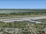
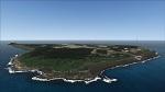
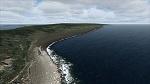
Iwo Jima Photoreal Scenery. Iwo Jima is a Japanese volcanic island. This is Photo real as it is today or as it was when the photo was taken (10-17-2011). The airport is IwoJima Aero (RJAW).
This is my first freeware release and therefore it may have some less then perfect attrubutes.
Also the photo was full of clouds and was less then steller. Still it was fun to make and I think looks
a whole lot better than default. There is no autogen included but I might add it later. I have added only minimal objects at this time. Danny R McMullan
Posted Nov 22, 2012 05:53 by Danny R McMullan
49.28Mb (1081 downloads)
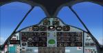
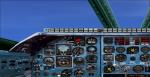
I re gauged Kazunori Ito's Tu-22 Blinder and Tu-22m3 Backfire 2D panels. Using Bill Wolfgen's Russian gauges, Thomas Ruth and Claudio Mussner's Tu-144 guages, Brett Hoskin's 3MS gauges, and gauges from Vladimir Zhyhulskiy. I used real photos to correctly re gauge the Tu-22m3 and used the same panel CFG for the original Tu-22 panel. But sense the Tu-22 Blinder is actually a three seat tandem bomber, i re gauged Kazunori Ito's X-3 panel with the same gauge sets, thus giving the choice between the two panels for the Tu-22. I included Michael Pearson's textures for India and Ukraine with the Tu-22m3. Plus Aircraft CFGs and AIR files for both aircraft. 2D panels only. No VC panels available.
Required files:
required file
Posted Nov 22, 2012 05:33 by Michael E. Roberts
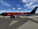
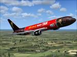
2.07Mb (207 downloads)
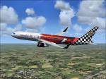
Fifa World cup trophy tour textures for the payware Level D Boeing 767-300ER winglet.
Textures by Peter Franeker.
Posted Nov 22, 2012 01:32 by Peter Franeker
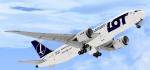
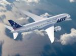
8.97Mb (2329 downloads)
SP-LRA Polish Airlines LOT textures for the payware Aerosim B787-8 Dreamliner.
Posted Nov 22, 2012 01:25 by Gregory
3.29Mb (1476 downloads)
GERMANY - EDKL (Leverkusen-Kurtekotten) Version 0.4 This is the first airfield, that I've created with Airport Design Editor (ADE) of Jon Masterson. I've tried to do the joby as close as possible to reality. Nevertheless, I'm mainly using standard FSX library objects, so that the exact look, the colour of buildings and other objects will differ. In the archive you'll find some aerial photos of the real airfield, so that you can give yourself your own impression of how well the work has succeeded. - - - !! Important: In order to function properly, this scenery necessarily needs a free, third-party library, which you have to install too !! If you don't install this library, most of the objects of the scenery will NOT BE DISPLAYED !!! You can download this free library at: http://www.flightport.de/index.php?id=369 Scroll down a little bit and klick on "Download FlightPort-Gmx-Lib 4.2.7" I have the permission of the library designers to use this fine stuff...:-)
Posted Nov 22, 2012 00:32 by Dirk Cremer