


FSX > Page 1197
6.59Mb (6591 downloads)
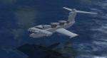
LUN Ekranoplan (Soviet Navy colors). The Lun-class Ekranoplan was designed in the late 1980s for the Soviet Union Forces. It uses a wing-in-ground-effect concept to skim low over the water at high speeds. The Lun, Russian for 'Dove', is also one of the largest aircraft ever built, rivalling the size of the Spruce Goose. This aircraft is fitted with six fixed-elevation SS-N-22 Sunburn anti-ship missile launchers. It was also known colloquially as the 'Caspian Sea Monster'. Full VC. Read docs how to fly! Ex payware from Alphasim/Virtavia
Posted Nov 2, 2012 08:35 by alphasim
0.23Mb (1802 downloads)
FSX/FS2004 T-34 Mentor fix.
This is a fix for the wheels and turning prop problem with the Beech T-34 Mentor in FSX Acceleration. Fix by A.F.Scrub
Required files:
required file
Posted Nov 2, 2012 06:43 by A.F.Scrub
0.72Mb (2910 downloads)
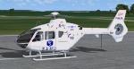
Textures for the freeware EC 135 by Heiko Richter updated by Danny Garnier. This repaint is the EC 135 of SAMU Air Rescue 94 based at the Hospital of Creteil, Paris.
Required files:
required file
Posted Nov 2, 2012 05:58 by Greenhopper
48.12Mb (4340 downloads)
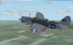
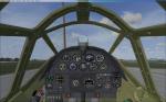
Curtiss SB2C-4 Helldiver, updated for FSX-Acceleration. All credits go to Wolfgang "Wolfi" Faber (see the original readme!). 2 Models, 5 liveries. Working VC, all necessary gauges included. Wings fold, divebrakes work together with the bombbay-doors, tailhook comes out, cowlflaps work and rear cockpit closes. Gun-effects for fun. Enjoy!
Posted Nov 1, 2012 19:29 by erik hertzberger
8.14Mb (1356 downloads)
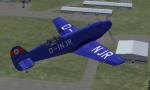
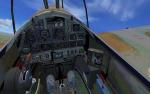
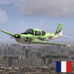
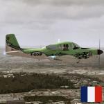
The first Me 209 was a completely new aircraft designed only to break speed records whose designation was used by Messerschmitt as a propaganda tool. Although the aircraft was a "single purpose" high-speed experimental prototype, it was hoped that its name would associate it and its world-beating performance with the Bf 109 already in combat service. ( Repaint of Me 209 V4 ). Original model designed by Patrice Grange.
Posted Nov 1, 2012 17:33 by Krop Alexander
3.29Mb (1081 downloads)
Textures for the freeware FSX Aero Commander-Meyers 200D BY Tim Conrad.
Required files:
required file
Posted Nov 1, 2012 15:09 by Greenhopper

50.87Mb (3237 downloads)
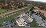
The scenery covers the airfield of Argenton-sur-Creuse, located in the Indre 5 km from the town of Argenton. It has a paved runway of 630 meters and another unpaved of 830 meters. A photorealistic ground retouched by a precision of 0,5 meter by pixel and an autogen are present on the scenery. Don't forget to read the Readme. Manual in French and English.
Posted Nov 1, 2012 10:13 by Flymandrier

53.02Mb (7328 downloads)
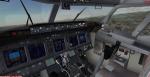
Skyspirit Boeing 737-800 Scandinavian Airlines/SAS with advanced VC.
For Microsoft Flight Simulator X upgraded to FSX using Alejandro Rojas Lucena/FSND revised
Boeing 737-800 VC. This model includes Working wipers (right mouse click on switch) with
rain effect. Switches for LCD Screens, EICAS, PFD, MFT. Autobrake switch. Opening pilots
window. Cabin Lights switch. Realistic FMC. Ground Proximity Warning System (GPWS), More
Realistic night textures. Also includes Boeing 737NG CFM56-7B soundset by Bendeguz Gabossy.
Skyspirit/Project Opensky native FSX Boeing 737-800 winglet model.
Textures by unknown.
Modified and assembled for FSX by Chris Evans.
Posted Nov 1, 2012 09:34 by Chris Evans
3.04Mb (353 downloads)
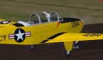
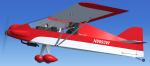
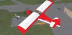
FSX Green Sky Adventures Zippy Sport repaint textures in red and white
for the fun flying Craig Richardson freeware Zippy Sport,
which you must have previously installed in FSX. Screenshots enclosed.
Easy installation. By Tom Tiedman.
Required files:
required file
Posted Nov 1, 2012 08:00 by Tom Tiedman
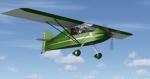
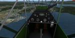
7.42Mb (2133 downloads)
The Zippy Sport is a single-seat, high-wing monoplane powered by a 50hp (37 kW) Rotax 503 piston engine. Of mixed construction (metal, wood and fabric), it has a fixed tail-dragger landing gear. The aircraft is available in the form of plans for amateur construction. The two prototypes which first flew in 1986 was used as a test bed for Rotax engines. Full animations, 3D gauges and Baked Textures. By Craig Richardson @ www.Classicwings.net
Posted Nov 1, 2012 06:38 by uploader