


FSX > Page 1200
(1617 downloads)
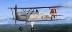
Bücker Bü 131A Jungmann. Aircraft by O. Fischer Repainted by Krop Alexander. The German Bücker Bü 131 "Jungmann" (Young man) was a 1930s basic training aircraft which was used by the Luftwaffe during World War II. Includes VC and custom gauges.
Posted Oct 30, 2012 10:33 by Krop Alexander
0.25Mb (891 downloads)
FSX cameras and gun effects for the Tupolev Tu-16 Badger rom Alphasim/now Virtavia. Requires Tupolev-Tu-16-Badger-FSX.zip from Simviation.com
ThatFS2004 Tu-16 flightmodel isfully FSX-compatible. My camera definitions provides 3 external close views, 4 external total views and 4 internal extra views, like bombardier and rear cockpit.
Gun effects can be triggered using Light- and smokesystem.
Configuration by Erwin Welker
Required files:
required file
Posted Oct 30, 2012 09:28 by Erwin Welker
38.11Mb (5529 downloads)
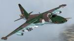
I compiled Kazunori Ito's FS2004/2002 Sukhoi Su-25K/TM(Su-39), Daniel CARERRI, BENOIT PLAMONDON & MARK CRANSTON -- AEROMUSICA "Pratt & Whitney PW JT8D Turbofan" sound set", and 11 additional textures with thumbnails by Michael Pearson. Included textures are: Ethiopian Air Force, North Korean Air Force, Turkmenistan Air Force, Angolan Air Force, Democratic Congo Air Force, Cote d' Ivoire Air Force, Eritrean Air Force, Belarus Air Force, Iranian Air Force, Fuerza Aerea Peru, Ukraine Airforce, Czech Airforce and Russian Airforce. I replaced the 2D panel gauges with ones from Jan Moravec's Su-15 2D panel and Vladimir Zhyhulskiy. I also gave it a ground/terrain radar. This package includes 15 textures and 2 models (Clean and Armed) for a total of 30 planes. No VC panel.
Posted Oct 30, 2012 01:44 by Michael E. Roberts

27.32Mb (9085 downloads)
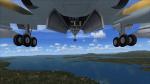
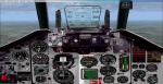
FSX Dornier Do328 JET ROYAL STAR AVIATION RP-C8328
32 seat twin turbofan regional airliner. All new model with full moving parts, doors with airstair and animated pilots. Accurate and pleasant flight dynamics. Fully modelled interior. Full documentation including manuals and check/ref lists. Custom panel and VC with digital (glass cockpit) gauges.
By Jean-Pierre Brisard and Bob May - Premier Aircraft Design.
Visit: http://www.royalstaraviation.com.ph/
Royal Star Aviation commercial aircraft (helicopter & fixed wing) charters. They secured their Certificate of Public Conveyance and Necessity from the Civil Aeronautics Board (CAB) on October 6, 1995 and Air Operator Certificate on September 15, 1998. Based in Ninoy Aquino International Airport (RPLL), General Aviation, Pasay City, Philippines.Repaint by Gerard G. Olvis
Posted Oct 29, 2012 23:33 by Gerard G. Olvis
0.12Mb (3027 downloads)
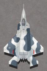
This package contains 2 sets of camera views ( defined by camera definitions in the aircraft.cfg file ) for
the beautiful Iris Simulations ex-payware Lockheed Martin F-22A Raptor ( Lightning II ).
Beware : this package is meant to be used with the "FSX F-22A Raptor Package".
A F-22A model by Virtavia is also available but I did not test my views with that one.
Version 1.0 cameras are located at about the same level of the aircraft.
Version 2.0 is based on version 1.0 but some of the cameras are placed at a higher level.
10 cameras pointing at the aircraft - including a new "Top-down" zoomable view.
Total of 6 VC cams including 2 new "Over the shoulder" views.
See Read me.txt file for very easy installation procedures.
Camera definitions sets are included in 2 separate text files.
And finally two more files - Available.pdf and Top 20.pdf for informations
about my "camera definitions" packages.
Required files:
required file
Posted Oct 29, 2012 16:08 by Marc Renaud
2.53Mb (923 downloads)
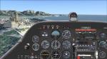
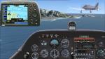
Widescreen 2D panel for François-Denis Guidée, Yves Franckart & Jean-Pierre Bourgeois' wonderful Robin DR221 updated to FSX by Jean-Paul Ventalon.
Includes main panel, landing/cruise panel, adapted minipanel and upgraded avionics.
The DR200 taildragger series are probably the best Robins ever!
DR221
available here (French site. See 'download instructions' in file for information) External link. Please report
when broken
Posted Oct 29, 2012 15:25 by Jean-Luc Peters
26.18Mb (4638 downloads)
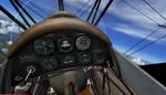
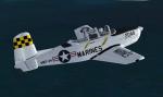
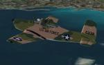
FSX/FS2004 Beechcraft T-34 Mentor
This is Alpha Sim's Freeware release of the T-34 Mentor upgraded to FSX. The T-34 Mentor began as a private venture designed by Walter Beech shortly after WW II. Beech felt that there was a market for a military trainer based on the Model 35 Bonanza which had been flying for about a year. The first two prototypes were powered by 205 hp Continental engines while the third had a more powerful 225 horsepower engine. The prototype made its first flight Dec. 2, 1948. This aircraft.mdl has updated 2D and 3D Panel, Flight Dynamics and gauges. It can also be flown in FS2004 and FSX acceleration. Upgrade by A.F.Scrub
Posted Oct 29, 2012 12:51 by A.F.Scrub
29.68Mb (5896 downloads)
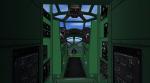
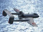
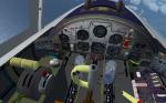
FSX/FS2004 SO 8000 Narval, full package, by Patrice Grange. The "Sud-Ouest" SO-8000 Narval was a French prototype designed in 1949 as a shipboard fighter and attack aircraft, with a particular twin-boom confuguration and two contra-rotating pushing propellers. The first flight took place on April 1st 1949. However, the program, like a few other ones in this period, was finally cancelled... This is a shame, since it was such a beautiful aircraft! The model has full moving parts and animations (control surfaces, gears, spoilers, canopy, weapons, ladder, ...) + a custom panel compatible with FS2004 and FSX + a VC. Fully compatible with both FS2004 and FSX (SP2).
Posted Oct 29, 2012 04:45 by Patrice Grange
155.31Mb (885 downloads)
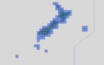
"imp" means imperfect, as other mesh I have already processed is of areas that have very little vegetation cover - over the land, or has large urban areas.
This "imp" mesh will include some slight discrepancies of altitude (in the case of forested areas - by a magnitude sometimes of +15 metres-depending on how tall the trees are, in the jungle or forest canopy) over urban areas, or areas with a lot of vegetation cover - due to the limitations of the ASTER satellites infra red scanning cameras, and the software used to process the DEM data.
Areas where there is little vegetation cover, or non urban areas, the terrain should have truer values.
But I feel this ASTER DEM data is so good - why let it all go to waste - especially flying over lovely Pacific islands?
So you FSX users out there will have to take all this into account when using this mesh.
Grateful thanks to ERSDAC, and NASA for making this data freely available to the public.
ASTER GDEM
Copyright (c) 2009 - 2011 Earth Remote Sensing Data Analysis Center (ERSDAC) All rights reserved.
ASTER GDEM is a product of METI and NASA.
Posted Oct 29, 2012 04:44 by Wayne Evans
19.25Mb (5028 downloads)
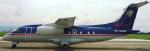
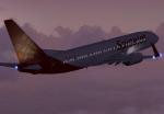
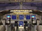
.The new Spice Jet fleet of the Boeing 737-800. SpiceJet is a low-cost airline headquartered in Chennai, India. Uses the Skyspirit FSX model, enhanced VC by Alejandro Lucena and ricardo_tv update and texture.
Enjoy flying NG's new generation
Posted Oct 29, 2012 04:14 by ricardo_tv