


FSX > Page 1204
0.13Mb (2810 downloads)
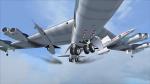
FSX camera definitions for the Boeing B-52 Stratofortress from Alphasim and updated by Steve Hess. (SCH_FSX_Alphasim_B52_101712).
My cameras provides 4 cockpit views, including the tactical room, 5 external views and 3 close views. 2 panel bitmaps to correct the transparent areas of the VC are included. Configuration by Erwin Welker
Required files:
required file
Posted Oct 23, 2012 07:18 by Erwin Welker
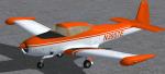
2.62Mb (419 downloads)
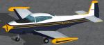
FSX Real World North American Navion Rangemaster (not a true Rangemaster
cabin model, but a Navion "B"? canopy/cockpit version with tip tanks).
Blue and yellow repaint textures only, based on the real world N8600H,
seen at the Commemorative Air Force Southern California Wing in Camarillo,
California. For the Schwertfeger-Leaming (RFS Design) freeware Navion,
which you must have previously installed in FSX. Includes her real world blue tinted glass. Your choice of a 4x3 or
widescreen 2D panel (or fly both), includes a simicon to lower the 2D panel
for excellent over the nose visibility (like the default Skyhawk has), and
also includes a VC. Screenshots included. Easy Installation. By Tom Tiedman.
Required files:
required file
Posted Oct 23, 2012 00:45 by Tom Tiedman
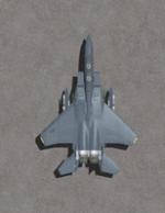
0.12Mb (1704 downloads)
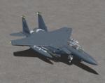
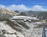
This package contains 2 sets of camera views ( defined by camera definitions in the aircraft.cfg file ) for the use with the "IRIS F-15E Strike Eagle full package" by David Brice/ IRIS Flight Simulation Software and converted to FSX by T. Marson.
Version 1.0 cameras are located about the same level of the aircraft.
Version 2.0 is based on version 1.0 but some of the cameras are placed at a higher level.
10 cameras pointing at the aircraft - including a new "Top-down" zoomable view.
Total of 5 VC cams including 2 new "Over the shoulder" views.
See Read me.txt file for very easy installation procedures.
Camera definitions are included in 2 separate text files.
And finally two more files - Available.pdf and Top 20.pdf for informations
about my "camera definitions" packages.
Required files:
required file
Posted Oct 22, 2012 22:31 by Marc Renaud

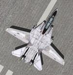
0.12Mb (4706 downloads)
This package contains 2 sets of camera views ( defined by camera definitions in the aircraft.cfg file ) for
the beautiful ( Acceleration ) Grumman F-14D Tomcat by DINO CATTANEO ( see his readme file for full credits ).
The first new set ( v 1.1) is actually based on my original package but with more views and some slight mods
to some parameters.
Version 2.0 is based on version 1.1 but some of the cameras are place at a higher level.
More outside views and more virtual cockpit views.
I also introduce a new camera view : the TOP-DOWN zoomable view. You can look straight down
at your plane as it flies over terrain or water. Hope you like it !
I use Jason Morgan's "Dino Cattaneo F14D Alternative Burners" for great effect !
See Read me.txt file for very easy installation procedures.
Camera definitions are included in 2 separate text file.
And finally two more files - Available.pdf and Top 20.pdf for informations
about my "camera definitions" packages.
Required files:
required file
Posted Oct 21, 2012 19:23 by Marc Renaud
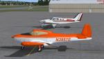
2.18Mb (282 downloads)
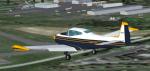
FSX North American Navion Rangemaster (not a true Rangemaster cabin model,
but a Navion "B"? canopy/cockpit version with tip tanks, N3957E).
Orange and white repaint textures only, for the Schwertfeger-Leaming
(RFS Design) freeware Navion, which you must have previously installed
in FSX. Your choice of a 4x3 or widescreen 2D panel (or fly both), includes
a simicon to lower the 2D panel for excellent over the nose visibility
(like the default Skyhawk has), and she also has a nice VC. Easy Installation.
By Tom Tiedman.
Required files:
required file
Posted Oct 21, 2012 12:19 by Tom Tiedman
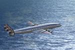
4.18Mb (635 downloads)
FSX/FS9 KLM L-1049C Textures for the L-1049G model by Manfred Jahn.
KLM textures by Gary Harper.
Required files:
required file
Posted Oct 20, 2012 23:41 by Gary Harper
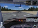
0.17Mb (877 downloads)
I would like to apologies for my over sight in the lack of the radio altimeter gauge when I uploaded the Florida_One-B737-700-FSX-3.zip. Just drop the FP_RA55 .cab into the main fsx gauges folder, and if you don´t have the Opensky_nacelle_refl.fx effect just drop into effects folder and that´s it.
Required files:
required file
Posted Oct 20, 2012 18:59 by Enrique Cornejo
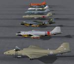
38.39Mb (1498 downloads)
FSX AI Aircraft. English Electric
Canberra's B2, PR3, T17A, TT18 and PR9.
PR9's comprise 5 individually numbered
aircraft for my new RAF retro Marham scenery
available in egym_1993_X_1.zip. Paint kit
included. Separate pack for FS9 is available
in: JY_Canberras_AI_FS9_1.zip.
By John Young, Airfield Construction Group.
Posted Oct 20, 2012 14:26 by mike
30.56Mb (978 downloads)
FSX AI Aircraft. Handly Page Victors:
B2 white+camo, with and without Blue Steel,
K2(Hemp+Camo) and SR2. K2s are 11
individually numbered aircraft for my new
RAF retro Marham scenery that is available
in egym_1993_9_1.zip. K2 model included that
deploys hoses at 18,000 ft and above.
Separate pack for FS9 is available in:
JY_Victors_AI_FS9_1.zip. Paint kit included.
By John Young, Airfield Construction Group.
Posted Oct 20, 2012 12:08 by mike
4.40Mb (943 downloads)
FSX AI Aircraft. NASA Martin WB-57F AI
Canberra's. Features the two aircraft
operating from Ellington Field Houston
Texas, plus the earlier paint scheme.
Separate pack in FS9 native code is in:
JY_WB57F_AI_FS9_1.zip.
By John Young, Airfield Construction Group.
Posted Oct 20, 2012 11:58 by mike