


FSX > Page 1205
16.42Mb (7877 downloads)
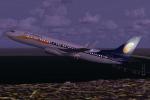
Boeing 737-800 Jet Airways, India's 2nd largest airline. Model by Project Opensky. Upgraded VC by Alejandro Rojas Lucenda, includes working wipers (right mouse click on switch) with rain effect. Switches for LCD Screens, EICAS, PFD, MFT. Autobrake switch. Opening pilots window. Cabin Lights switch. Realistic FMC. Ground Proximity Warning System (GPWS). Update and textures by ricardo_tv.
Enjoy
Posted Oct 19, 2012 16:38 by ricardo_tv

36.17Mb (5735 downloads)
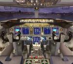
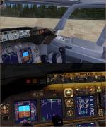
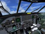
SkySpirit 2011 Korean Air Cargo Boeing 747-800 with advanced VC
Assembled and edited for FSX with default B7474 VC, by Chris Evans. Thank you to Skyspirit for their wonderful models. Beautiful Korean Cargo repaint by Mathieu Vos. With Enhanced VC from Alejandro Rojas Lucenda.
Skyspirit FSX native Boeing 747-8F model upgraded using the vastly improved Boeing 747 VC from Alejandro Rojas Lucena/FSND (See panel docs for details). VC includes FMC, EICAS, MFD with control panel, GPWS, working wipers, cabin lights, fire suppression, avionics switch, fuel crossfeed, landing lights switches, taxi light switch, engine generators, APU generator, battery switch, starter switches, de-ice switch, general lights switches. Beautiful Skyspirit 747-800 cargo model with complex features and ground service vehicles (press shift e 2, shift e 3, etc. ). To use jetway press Ctrl J.
Also includes the Boeing 747 VC textures upgrade textures. This give a much clearer 747 interior virtual cockpit look.
Assembled and edited for FSX by Chris Evans.
Posted Oct 19, 2012 10:32 by Chris Evans
5.34Mb (4109 downloads)
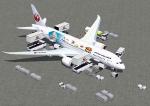
FSX Japan Airlines "Ghibli Jet" Boeing 787-8 v4. This CamSim version 4 features an improved aircraft wing root design,
new wider pax doors with revised window shapes, additional animated air ducts, additional comm and satellite antennas,
increasingly more Animated Ground Servicing (AGS), including additional animations featuring trucks hooking and unhooking trailers and static displays.
Model design and paint by Camil Valiquette.
Posted Oct 19, 2012 08:41 by Camil Valiquette
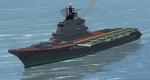
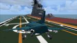
2.69Mb (2361 downloads)
FSX Features for a Pilotable USSR Carrier Kiev. A download of the ai-versions from Harri Thaha and Hadi Tahir is required (ht_kiev02-1.zip). My AddOn provides a pilotable ship with bridge, sounds and special effects like forward firing guns, simulated missile launch and distant explosions.
8 camera views let you explore the ship. The VTOL-fighter Yak-38 can be set onto the deck and with a special gimmick you even can rise or lower the vertical take off or landing sequence. From the eyepoint of a gunner you can rotate the front or rear 7,5 cm twin gun. Bitmaps and configuration by Erwin Welker
Required files:
required file
Posted Oct 19, 2012 04:38 by Erwin Welker
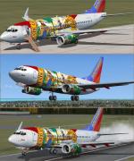
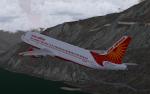
42.70Mb (5101 downloads)
Boeing 737-700 Southwest "Florida One" winglets with advanced VC.
Skyspirit/Project Opensky native FSX Boeing 737-700 winglet model. Upgraded using the revised Boeing 737-800 VC by Alejandro Rojas Lucena with further updates by Enrique Cornejo. This model
includes working wipers (right mouse click on switch) with rain effect. Switches for LCD Screens, EICAS, PFD, MFT. Autobrake switch.
Opening pilots window. Cabin Lights switch. Realistic FMC. Ground Proximity Warning System (GPWS), FSX native model winglet by
Skyspirit/Project Opensky.
High quality "Florida One" 32 bit textures.
Now the backup altimeter and airspeed works in VC, the landing gear contact points are in level position, also I added new cockpit and
aircraft views. This aircraft has smoke effects, reworked night lights, more realistic tail night light, realistic Cockpit sounds, repaint VC cockpit and others.
Textures and edits by Enrique Cornejo
Posted Oct 18, 2012 17:10 by Enrique Cornejo

41.48Mb (3919 downloads)
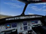
Project Airbus A320 in Peach Airlines livery.
Peach is a low-cost airline based in Japan.
Peach's first Airbus A320 was delivered to its home base at Kansai International Airport, Japan, in November 2011. VC Included.
Painted by Stephen Browning
Posted Oct 18, 2012 11:52 by Stephen Browning

15.43Mb (25223 downloads)
Alphasim freeware B-52 Stratofortress complete aircraft package. I have fixed the missing VC textures in FSX and engine smoke position. Added thumbnails and edited the Bare metal textures. Fixed a few gauge issues.
Posted Oct 17, 2012 23:23 by Steve Hess

12.85Mb (1783 downloads)
I updated Dennis Simanaitis's Tupolev ANT-20 "Maksim Gorkii" by replacing the incompatible gauges in the 2d and VC panels with Vladimir Zhyhulskiy's gauges. And adding the texture thumbnail plus replacing the glass and prop textures. includes both 2d and VC panels.
Posted Oct 17, 2012 19:54 by Michael E. Roberts
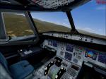
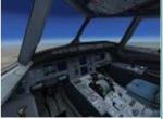
23.55Mb (9519 downloads)
Upgraded VC for Airbus. -NEW PFD(almost same as in real Airbus)
-Navigation Display is realistic
-New ECAM displays
-Auto Brakes added and working
-Cockpit Textures. Works with the Project Airbus A320 family and the FSX default A321. Not tested with Thomas Ruth A330 and A340 nor PA A380. Go to zip preview for more info. [As always with these things - back up your originals in case you want to go back!]
Posted Oct 17, 2012 16:15 by Amar
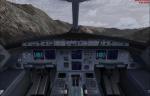
30.78Mb (4783 downloads)
Another Air India Airbus, now the Posky A320-212, including the default Airbus 321 VC and Posky effects.
Model by Project Opensky, texture and updates by ricardo_tv
Enjoy
Posted Oct 17, 2012 15:38 by ricardo_tv