


FSX > Page 1207
25.11Mb (3538 downloads)
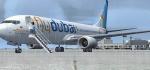
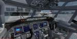
Boeing 737-8K2 Flydubai with advanced VC.
Complete package for FSX only of the Posky Boeing 737-800WL model in Flydubai livery,registration A6-FDW,the "7000th" 737 produced by Boeing FSX WE model included. Repaint by Mohammed Al-Khalifa. Upgraded to FSX using Alrot's revised Boeing 737-800 VC. This model includes Working wipers (right mouse click on switch) with rain effect. Switches for LCD Screens, EICAS, PFD, MFT. Autobrake switch. Opening pilots window. Cabin Lights switch. Realistic FMC. Ground Proximity Warning System (GPWS), More Realistic night textures.
Skyspirit/Project Opensky native FSX Boeing 737-800 winglet model.
Textures by Mohammed Al-Khalifa.
Modified for FSX with Alejandro VC and default VC textures by Chris Evans.
Posted Oct 13, 2012 14:23 by chris evans
41.44Mb (6373 downloads)
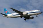
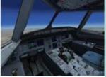
Project Airbus A320 in China Southern Airlines livery. VC Included.
Painted by Stephen Browning
Posted Oct 13, 2012 09:56 by Stephen Browning
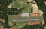
0.00Mb (841 downloads)
TRPG- John A. Osborne Airport near the village of Gerald's on the island of Montserrat, a British Overseas Territory in the Caribbean. It has a small runway of 1814.3 ft. Interesting flying!
Posted Oct 12, 2012 13:49 by Àdam Elias
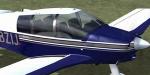
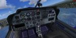
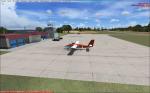
33.55Mb (14268 downloads)
Robin DR-400 Package adapted for FSX. Updated 2012.
Original
Amazing DR400 by Yannick Lavigne. Updated with new FSX gauges. This is a beautiful
airplane to fly VFR in FSX! Yannick Lavigne is one of the greatest freeware designers
and he was so advanced in his time.
Includes
Robin 135 CDI with TAE-Centurion 1.7 motor.
4 textures by Patrick Machabert and Christian Winkel. Panel Updates October 2012 by
Danny Garnier.
Posted Oct 12, 2012 08:06 by Garnier D
5.00Mb (1032 downloads)
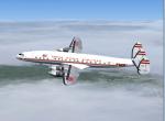
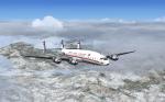
FSX TWA L-1049 model and textures. Model by Manfred Jahn.
Trans World textures by Gary Harper.
Required files:
required file
Posted Oct 11, 2012 21:37 by Gary Harper
12.85Mb (7540 downloads)
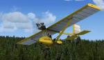
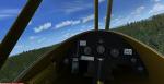
Whittaker MW6 microlight with Full animations, 3D gauges and Baked Textures. By Craig Richardson
Posted Oct 11, 2012 10:20 by uploader
19.16Mb (9123 downloads)
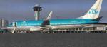
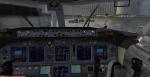
Boeing 737-800 KLM Royal Dutch Airlines "PH-BGA" with advanced VC.
for Microsoft Flight Simulator X upgraded to FSX using Alrot's revised Boeing 737-800 VC. This model includes Working wipers (right mouse click on switch) with rain effect. Switches for LCD Screens, EICAS, PFD, MFT. Autobrake switch. Opening pilots window. Cabin Lights switch. Realistic FMC. Ground Proximity Warning System (GPWS), More Realistic night textures.
Skyspirit/Project Opensky native FSX Boeing 737-800 winglet model.
Textures by Mathieu Vos.
Modified and assembled for FSX by Chris Evans.
Posted Oct 10, 2012 13:22 by Chris Evans
12.54Mb (5722 downloads)
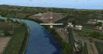
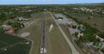
Located about 5 miles north of LIPX Verona and 9 miles east Garda Lake, LIPN "Angelo Berardi" Boscomantico today is the turistic
airport of the city famous for the Arena and the tragedy of Romeo and Juliet written early in the career of William Shakespeare.
Founded in 1928 whit airship activity now whit his 1000 meters concrete runway offer a good starting point
for the flight school operated by the local and historic Verona Aeroclub.
General aviation aircraft, Helicopter, Ultraligt, Advanced LSA, Gliders, skydiving activity...a very nice convivence for aviation passion
at all levels. The area cover by VicDabor outside the airport is many populated, more 6000 trees, more 1000 building, churches and much more..
That's all, the moment for flying LIPN is coming!
Scenery building by Dario "VicDabor", thanks for AFcad by Mattia Esposito, beta test and supervision by Bruno "BUNGEE"
Thank's and Soft Landing
Info link and future updates here: http://vicdabor.blogfree.net/
Posted Oct 10, 2012 13:19 by Dario "Vic Dabor" Bortot
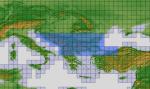
254.73Mb (2823 downloads)
"imp" means imperfect, as other mesh I have already processed is of areas that have very little vegetation cover - over the land, or has large urban areas.
This "imp" mesh will include some slight discrepancies of altitude (in the case of forested areas - by a magnitude sometimes of +15 metres-depending on how tall the trees are, in the jungle or forest canopy) over urban areas, or areas with a lot of vegetation cover - due to the limitations of the ASTER satellites infra red scanning cameras, and the software used to process the DEM data.
Areas where there is little vegetation cover, or non urban areas, the terrain should have truer values.
But I feel this ASTER DEM data is so good - why let it all go to waste - especially flying over lovely Pacific islands?
So you FSX users out there will have to take all this into account when using this mesh.
Grateful thanks to ERSDAC, and NASA for making this data freely available to the public.
ASTER GDEM
Copyright (c) 2009 - 2011 Earth Remote Sensing Data Analysis Center (ERSDAC) All rights reserved.
ASTER GDEM is a product of METI and NASA.
Posted Oct 10, 2012 06:29 by Wayne Evans
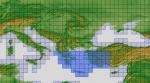
131.52Mb (2269 downloads)
"imp" means imperfect, as other mesh I have already processed is of areas that have very little vegetation cover - over the land, or has large urban areas.
This "imp" mesh will include some slight discrepancies of altitude (in the case of forested areas - by a magnitude sometimes of +15 metres-depending on how tall the trees are, in the jungle or forest canopy) over urban areas, or areas with a lot of vegetation cover - due to the limitations of the ASTER satellites infra red scanning cameras, and the software used to process the DEM data.
Areas where there is little vegetation cover, or non urban areas, the terrain should have truer values.
But I feel this ASTER DEM data is so good - why let it all go to waste - especially flying over lovely Pacific islands?
So you FSX users out there will have to take all this into account when using this mesh.
Grateful thanks to ERSDAC, and NASA for making this data freely available to the public.
ASTER GDEM
Copyright (c) 2009 - 2011 Earth Remote Sensing Data Analysis Center (ERSDAC) All rights reserved.
ASTER GDEM is a product of METI and NASA.
Posted Oct 10, 2012 06:18 by Wayne Evans