


FSX > Page 1209
20.43Mb (4370 downloads)
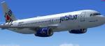
Airbus A320-230 jetBlue 'I Love Blue York' for FSX.
Includes default A321 VC.
Model by Project Airbus. Textures by
Xudeva Irribarra. Assembled/edited for FSX by Chris Evans.
Posted Oct 8, 2012 08:13 by chris evans
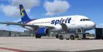
13.73Mb (6208 downloads)
Airbus A319 Spirit Airlines N533NK for FSX. Spirit is a US low-cost carrier headquartered in Miramar, Florida. Spirit operates scheduled flights throughout the U.S. as well as the Caribbean Sea area, Mexico, and Latin America. In 2011, Spirit achieved $1 billion dollars in annual revenues and was thereby classified a major airline by the US Department of Transportation.
Includes default A321 VC.
Model by Project Airbus. Textures by
Thomas Eisenbach. Assembled/edited for FSX by Chris Evans.
Posted Oct 8, 2012 08:01 by chris evans
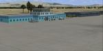
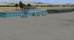
11.34Mb (692 downloads)
Kunduz Airport Afghanistan. Custom built models with a photoreal background that changes with the seasons.
Posted Oct 8, 2012 04:49 by Jacques Botha
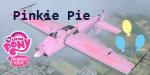
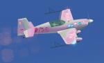
6.58Mb (499 downloads)
This default FSX Extra 300 texture is ready to break the fourth wall. This Pinkie Pie texture comes complete with a beautiful exterior and a Pinkielicious interior! I also added an optional Cotton Candy Smoke effect.
Texture based off of Hasbro's My Little Pony Friendship is Magic.
Texture By: Fay "Twitchy" Cheung
Smoke By: Daniel B. AKA Skyguy757
Posted Oct 8, 2012 04:31 by DanielA.Boyer
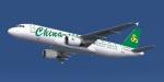
14.95Mb (4101 downloads)
Spring Airlines Airbus A320-214 for Flight Simulator X. Aircraft model and texture of B-6840 are included, along with panel, sound & virtual cockpit from the default A321. Original aircraft by Project Airbus, texture by Lingyuan He from China. Note: This package can be used in FS9, please read the instructions inside the package.
Posted Oct 7, 2012 18:04 by Lingyuan He
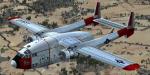
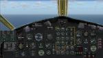
8.01Mb (7376 downloads)
This transport aircraft was designed just after WW2 (first flight in 1947) and was produced until 1955 (1183 units). The Boxcar was a very versatile aircraft used as cargo, troops and personnel transport. Credits: Mike Stone for the original model. Adaptation to FSX, 2D panel for wide and standard screen (no VC) by Philippe Wallaert. See instructions for installation and configuration in the readme.txt file. Nice flights!
Posted Oct 7, 2012 03:24 by Philippe Wallaert
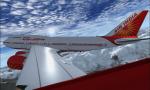
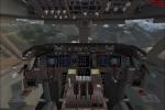
24.12Mb (5652 downloads)
The new Air India Boeing 747-451 PW, can carry 405 passengers in 3 class at 35,000 ft (11,000 m) in Mach 0.855. Textures dds HD with new light's and new VC gauges in black by ricardo_tv.
Model by Posky, advanced vc by Alejandro Rojas Lucena/FSND and texture by ricardo_tv.
Posted Oct 6, 2012 20:06 by ricardo_tv
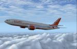
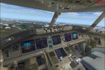
26.48Mb (5386 downloads)
The new Air India Boeing 777-200ER GE, textures dds HD with new lights. Can carry 395 passengers in 2 class with a range of 7,725 nmi(14,310 km) at 43,100 ft (13,140 m) in Mach 0.86.
Model by SMS and texture by ricardo_tv.
Posted Oct 6, 2012 18:13 by ricardo_tv
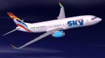
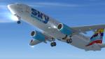
16.00Mb (1939 downloads)
Textures for the default FSX B737-800. German Sky Airlines GmbH commenced business as a travel agency in 2004.
In 2010, after the purchase of a couple of 737-800’s, it became based at Dusseldorf International, mainly servicing holiday flights to destinations in Turkey.
The company is owned by the Kayi Group, a Turkish tourism organisation.
This repaint is based on D-AGSA and is texture only
Posted Oct 6, 2012 06:49 by Paul Davies
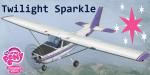
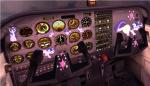
3.48Mb (798 downloads)
This is a Twilight Sparkle texture pack for the default FSX Cessna C-172SP. Textures include new decals and a custom "Twilighlicious" interior.
Based off of Hasbro's My Little Pony Friendship is Magic series.
Textures By: Fay "Twitchy" Cheung
Posted Oct 6, 2012 05:36 by DanielA.B.