


FSX > Page 1206
7.77Mb (442 downloads)
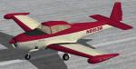
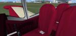
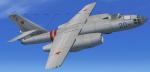
FSX North American Navion Rangemaster (not a true Rangemaster cabin model,
but a Navion "B"? canopy/cockpit version with tip tanks, N8953W).
Burgundy and cream repaint textures only, for the Schwertfeger-Leaming
(RFS Design) freeware Navion, which you must have previously installed
in FSX. Your choice of a 4x3 or widescreen 2D panel (or fly both), includes
a simicon to lower the 2D panel for excellent over the nose visibility
(like the default Skyhawk has), and she also has a nice VC. My part in this
was to paint her, precisely locate the outline for the baggage door,
change her windows from a dark black to a more transparent mild golden tint,
and provide air show smoke coordinates to spew from the starboard side
exhaust stack. Screenshots included. Easy Installation.
By Tom Tiedman.
Required files:
required file
Posted Oct 17, 2012 13:57 by Tom Tiedman
5.82Mb (2144 downloads)
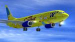
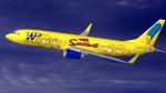
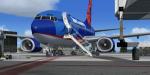
Western Pacific Textures for the default FSX Boeing 737-800. Western Pacific Airlines commenced service in April 1995 with a fleet of eight 737-300’s.
WestPac, as it became known, operated to Las Angeles, Phoenix, Oklahoma and Las Vegas.
Logo Jets were a big theme for the airline drawing in money and commanding attention.
Unfortunately a failed merger with Frontier Airlines saw WP declare bankruptcy in 1998.
This repaint is based on the much loved ‘Simpsons’ Logo Jet N949WP.
Posted Oct 17, 2012 10:58 by Paul Davies
56.61Mb (12460 downloads)
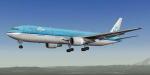
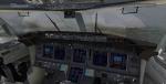
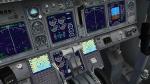
KLM - Royal Dutch Airlines Boeing 767-300ER v5 with VC.
Upgraded to FSX using the revised Boeing 737-800 VC. This cockpit includes Working wipers (right mouse click on switch) with rain effect. Switches for LCD Screens, EICAS, PFD, MFT. Autobrake switch. Opening pilots window. Cabin Lights switch. Realistic FMC. Ground Proximity Warning System (GPWS), More Realistic night textures. Model features High resolution textures, Dynamic flexing wings, Body gear steering, Nose gear steering, Rudder lock, Ground spoilers, Low speed aileron locks at high speed, Fully animated control surfaces, Fully independent suspension, Trim Animation, Opening Passenger Doors, Animated tilting bogies, Rolling wheels, Animated thrust reverser's with reverser block doors, Detailed textures, Full night lighting, Crash affects, Ground Service Vehicles And more. Model Designer Hiroshi Igami. Flight Dynamics Designer Warren C. Daniel. KLM repaint by Skyspirit team member. FSX native model by Skyspirit/Project Opensky. VC by Alejandro Rojas Lucena (Alrot). Modified for FSX by Chris Evans.
Modified and assembled for FSX by Chris Evans.
Posted Oct 17, 2012 06:11 by Chris Evans
4.14Mb (2284 downloads)
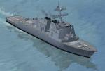
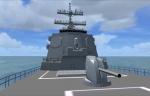
FSX features for a pilotable Arleigh Burke Class Guided Missile Destroyer. A download of the ai-versions from Lazarus Starkweather is required (FSX_AI_DDG-51_flight_1.zip). My AddOn provides a pilotable ship with bridge, sounds and special effects like forward firing guns, simulated missile lauches and distant explosions. 7 camera views let you explore the ship: F.i. standing at the flybridge, at the bow or at the stern. Here you can place a Sealynx helicopter onto the flight deck. Bitmaps and configuration by Erwin Welker
Required files:
required file
Posted Oct 17, 2012 04:30 by Erwin Welker
5.00Mb (5799 downloads)
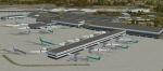
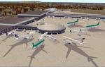
EIDW - Dublin Intl - Dublin, Ireland (v1.1)
Dublin Airport is the headquarters of Ireland's flag carrier (Aer Lingus), Europe's largest low-cost carrier (Ryanair) and Ireland's regional airline (Aer Arann). Ireland's fourth airline, CityJet, operates flights from the airport.
Posted Oct 17, 2012 03:58 by uploader
2.75Mb (4029 downloads)
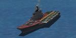
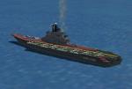
FSX Kiev- aircraft carrier, with landable flight deck. To be used as AI or with AICarriers2. Kiev was a heavy aircraft carrying cruiser that served the Soviet and Russian navies from 1975 to 1993. It was built between 1970 and 1975 at Chernomorski factory in Mykolaiv and was the first ship of its class (Project 1143 Krechyet (Gyrfalcon) or Kiev class). by Harri Thaha & Hadi Tahir
Posted Oct 17, 2012 01:15 by Hadi Tahir
18.95Mb (3630 downloads)
Boeing 737-700 Sun Country with advanced VC
for Microsoft Flight Simulator X.
Skyspirit/Project Opensky native FSX Boeing 737-700 model. Sun Country obtained this aircraft from Easyjet and flies on routes that do not require the capacity of
the larger 737-800.
Upgraded to FSX using Alrot's revised Boeing 737-800 VC. This model includes Working wipers (right mouse click on switch) with rain effect. Switches for LCD Screens, EICAS, PFD, MFT. Autobrake switch. Opening pilots window. Cabin Lights switch. Realistic FMC. Ground Proximity Warning System (GPWS), More Realistic night textures.
FSX native model by Skyspirit/Project Opensky.
Textures by Joe Shimmel.
Modified and assembled for FSX by Chris Evans.
Posted Oct 16, 2012 11:14 by Chris Evans
51.43Mb (18223 downloads)
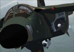
If you ever wanted to fly the F-111 skimming the tree tops at high speeds and whip around a mountain in a 60 degree bank while the autopilot does all the work, then this is the aircraft package for you. Our update has the only True Terrain Following Radar system with Pitch and Roll Stabilization that looks ahead of the aircraft to avoid mountains. It is integrated into the Autopilot and Instrument systems for Auto or Manual TF operation. The autopilot system models the real F-111 autopilot Stability Augmentation Modes with pitch and roll sub-channels. Control Stick Steering uses Pitch and/or Roll control stick input to override the pitch and/or roll autopilot channel(s) without disengaging the autopilot settings. The autopilot settings are re-engaged using a button on your control stick (bound to the "t" key) returning the aircraft to autopilot control. There are 4 different Custom 2D and VC Cockpits, Aircraft included are F-111E, F-111F, F-111G, FB-111A, FB-111A with pre AMPS avionics, and YFB-111A. 16 Custom textures with a description for that tail number in the aircraft details menu. Over 110 functional gauges and switches. Included is a custom sound package. See the features Doc for more details. For maximum enjoyment please read the documentation!!! This package is based on the Alphasim F-111 freeware aircraft and is highly modified for FSX SP2 and Acceleration. Fixed missing effects.
Posted Oct 15, 2012 12:15 by Steven Hess and Roman Stoviak
51.07Mb (2952 downloads)
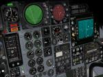
I updated Ralf Kreibich's FS2004 Ilyushin IL-28 Beagle by reworking the panel config file. I kept it 90 percent original. I also added texture thumbnails and HJG's CV990a smoke effects. No VC panel.
Posted Oct 15, 2012 09:46 by Michael E. Roberts
7.47Mb (1087 downloads)
I updated the panel config file for the Samdim Tu-124 keeping it 90 percent origional. this is a 2D panel only, No VC. Can be used for either the Tu-104 or Tu-124.
Required files:
required file
Posted Oct 15, 2012 01:12 by Michael E. Roberts