


FSX > Page 1267
27.52Mb (9692 downloads)
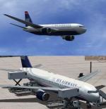
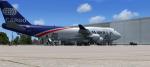
US Airways Boeing 767-2B7/ER (N246AY) NC painted on SkySpirit2010's native FSX Boeing 767-200 V5 model.
aircraft. US Airways currenly operate 10 B767-200's.
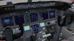
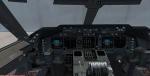
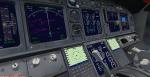
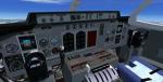
Upgraded to FSX using Alrot's revised Boeing 737-800 VC. This model includes Working
wipers (right mouse click on switch) with rain effect. Switches for LCD Screens, EICAS,
PFD, MFT. Autobrake switch. Opening pilots window. Cabin Lights switch. Realistic FMC.
Ground Proximity Warning System (GPWS), More Realistic night textures. Model features
High resolution textures, Dynamic flexing wings, Body gear steering, Nose gear
steering, Rudder lock, Ground spoilers, Low speed aileron locks at high speed, Fully
animated control surfaces, Fully independent suspension, Trim Animation, Opening
Passenger Doors, Animated tilting bogies, Rolling wheels, Animated thrust reverser's
with reverser block doors, Detailed textures, Full night lighting, Crash affects,
Ground Service Vehicles And more. Model Designer Hiroshi Igami/Yosuke Ube. Flight
Dynamics Designer Warren C. Daniel. Painted by Dietmar Hanne.
FSX native model by Skyspirit/Project Opensky. VC by Alejandro Rojas Lucena (Alrot).
Modified for FSX by Chris Evans.
Posted May 24, 2012 07:44 by Chris Evans
9.32Mb (8852 downloads)
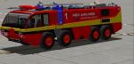
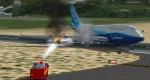
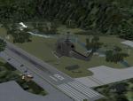
Red airlines fire truck with water hose effects. Original fire truck by Mitsuya Hamaguchi
Posted May 24, 2012 06:44 by Bigdog2995
21.62Mb (1420 downloads)
Boeing 747-400BDSF/BCF World Airways Cargo package. FSX native cargo model by Project
Opensky.
By paint by Wayne Jarrett on request. Includes ground services (Views - Instrument
Panel - Posky Utilities).
Aircraft fixed to work properly in FSX with correct pilot position in VC, altered VC
textures. Mods by Chris Evans.
Posted May 24, 2012 06:22 by Chris Evans
0.36Mb (1267 downloads)
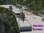
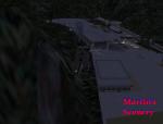
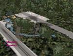
Fictional Vietnam Camp headquarters.
Posted May 23, 2012 17:04 by Martin
0.00Mb (267 downloads)
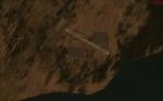
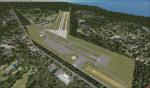
PALR Chandalar Lake fictional airport.
PALR is a medium airport near to the Chandalar Lake in Alaska.
Posted May 23, 2012 05:57 by uploader
0.36Mb (1519 downloads)
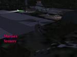
Fictional military medical camp deep in the Vietnam jungle.
Posted May 23, 2012 03:23 by Martin
2.40Mb (1123 downloads)
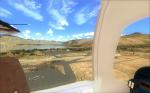
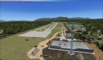
This is a stock Airport on FSX I added a lot of scenery items for you to look at. By no means is the made to look like the real airport Hope you enjoy. Zip view for more images.
Posted May 23, 2012 02:16 by uploader
15.94Mb (5995 downloads)
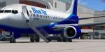
FSX Boeing 737-800NG Blue Air
Model: Project Opensky
Repaint: Matteo Arrotta
POSKY FSX 737-800W model included.
Skyspirit/Project Opensky native FSX Boeing 737-800 NG winglet model.
Blue Air is a low-cost airline based in Bucharest, Romania, operating mostly out of Henri Coanda International Airport
Upgraded to FSX using Alrot's revised Boeing 737-800 VC. This model includes Working
wipers (right mouse click on switch) with rain effect. Switches for LCD Screens, EICAS,
PFD, MFT. Autobrake switch. Opening pilots window. Cabin Lights switch. Realistic FMC.
Ground Proximity Warning System (GPWS), More Realistic night textures.
FSX native model winglet by Skyspirit/Project Opensky.
Textures by Matteo Arrotta. FSX updates by Chris Evans.
Posted May 22, 2012 15:08 by Chris Evans
47.72Mb (18258 downloads)
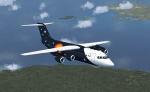
FSX BAe 146-200 Titan Airways. Textures fixed.
The 146-200 is a 'stretched' version of the 146-100, a medium sized commercial aircraft,
powered by four turbofan jet engines, which was manufactured in the United Kingdom
by British Aerospace. Production ran from 1983 until 2002. In August 2008, a total of 140
BAE 146 aircraft (all variants) remained in airline service worldwide. The aircraft
has very quiet operation, it sees wide usage at small city-based airports. In its
primary role it serves as a regional jet, short-haul airliner or regional airliner.
Full package for FSX/SP2 with custom panels and VC, full moving parts and air stairs.
Realistic and pleasant flight dynamics. The package includes 3 liveries, Air France,
Flybe and Airlink (SA).
Model by Jean-Pierre Brisard and Bob May - Premier Aircraft Design.
Posted May 22, 2012 06:55 by Stephen Browning
0.36Mb (1431 downloads)
Fictional Military Vietnam Forest Camp.
Posted May 22, 2012 04:52 by Martin