


FSX > Page 1265
32.96Mb (13119 downloads)
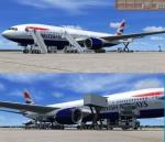
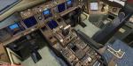
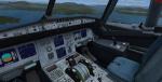
British Airways Boeing 777-200ER BA G-YMMD livery painted on Project Opensky's Boeing 777-200 VC model.
The textures are saved in 32bit format for quality graphics.
Includes VC edited by Danny Garnier.
Wonderful Boeing 777-200ER Trent VC model by Project Opensky.
Includes ground services (Views - Instrument Panel - Posky Utilities).
Textures by Daniel Alamilla.
Happy Flying!
Updated for FSX by Chris Evans
Posted May 28, 2012 08:42 by Chris Evans
2.70Mb (1253 downloads)
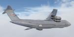
This is a repaint of the Area 51 Simulations C-5M Super Galaxy. This aircraft represents aircraft 90014, assigned to the 433d Airbase Wing at Lackland AFB, Kelly Field Annex.
Posted May 27, 2012 10:13 by KiltinSA

16.58Mb (7425 downloads)
FSX Wizz Air A320-232 IAE. A repaint of Project Airbus A320-200 IAE model in the colors of Wizz Air, registration HA-LPT. Coupled to the default A321 VC. Repainted by: Mohammed Al-Khalifa.
Posted May 27, 2012 06:36 by uploader
5.61Mb (1330 downloads)
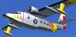
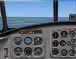
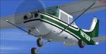
Livery of the HU-16 Spanish Air Army. It's an old texture adapted to the new version HU-16 Albatross FS2004/FSX (required) by Greg Pepper and Michael Verlin. I also include another FSX update for the panel, using original FSX gauges.
Required files:
required file
Posted May 27, 2012 05:38 by Enrique Medal
0.10Mb (1697 downloads)
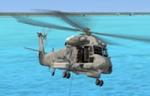
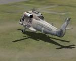
Views ( defined by camera definitions in the aircraft.cfg file )
for the beautiful Kaman SH-2G Seasprite. Original model by Adrian Brausch & Nigel Booth.
VC modified by MaDRich.
8 cameras pointing at the aircraft and a total of 5 views in the 3D cockpit.
See Read me.txt file for very easy installation procedures.
One camera definitions.txt file for all models
And finally two more files - Available.pdf and Top 20.pdf for informations
about my "camera definitions" packages.
Required files:
required file
Posted May 27, 2012 02:21 by Marc Renaud
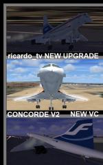
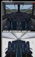
139.53Mb (45308 downloads)
PM Concorde Package revised edition for FSX. The Concorde was the only successful supersonic jetliner for 27 years, made by the British and French engineers who made the most beautiful airplane in the world. Since 1976 started, before Tu-144, it became more popular to be the fastest in human history. At the same time there appeared other rivals like the Boeing 747, just because it takes more passenger in 8Hrs when Concorde 300-400 passenger in 7.30 Hrs in 4 flights. Original model created by the FS France Team. In this Pack are the following Airlines: Prototype, Air France (new/old/Pepsi), British Airways (new/old/former), Alitalia, Finnair, Hawaiian, KLM, Lufthansa, Qantas & Singapore Airlines. New Interior cabin & exterior textures making flying the Concorde more realistic with wing and smoke effects. Happy Hero maker: D
Posted May 26, 2012 02:39 by ricardo_tv
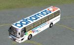
0.37Mb (1928 downloads)
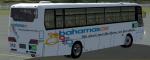
Hama 1000 airport bus with a fictional livery for Bahamasair. Original credits to Mitsuya Hamaguchi for model with ricardo_tv update.
Required files:
required file
Posted May 25, 2012 21:15 by nickthatch12
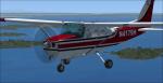
5.92Mb (556 downloads)
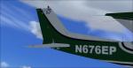
Textures only for the default Cessna 172 in the fictional N676EP. It is a green Cessna 172 with some black. The livery and the tail number is fictional. There are instructions on how to install in the readme file. By Tyler Lawrence.
Posted May 25, 2012 18:41 by Tyler Lawrence
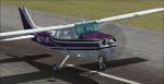
5.84Mb (401 downloads)
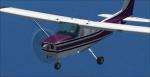
Textures only for the default Cessna 172 in the fictional N971JR. It is a purple Cessna 172 with some black. The livery and the tail number are fictional. There are instructions on how to install in the readme file. By Tyler Lawrence.
Posted May 25, 2012 18:36 by Tyler Lawrence
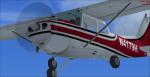
5.45Mb (464 downloads)
Textures only for the default Cessna 172 in the fictional N4179H. It is a maroon Cessna 172 with some black. The livery and the tail number are fictional. There are instructions on how to install in the readme file. By Tyler Lawrence.
Posted May 25, 2012 18:31 by Tyler Lawrence