


FSX > Page 1269
2.11Mb (2295 downloads)
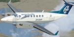
Air New Zealand textures for the default FSX Beech King Air 350
Posted May 20, 2012 04:46 by Kiedis Templeton-Viel
103.77Mb (354 downloads)
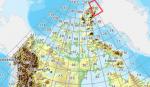
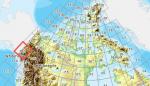
As Raimondo Taburet hasn't processed the CDED files above 60 degrees latitude for Canada, well here are the ones I have processed.
There isn't any data available from geobase in some of the blocks above 60 degrees latitude, these are blocks: 15, 17, 18, 28, 108, 109, 118, 119.
See jpg for coverage.
Thanks go to Geobase (Copyright) Canada for the availability & public use of this data.
Posted May 20, 2012 04:19 by Wayne Evans

35.46Mb (346 downloads)
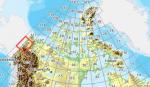
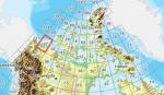
As Raimondo Taburet hasn't processed the CDED files above 60 degrees latitude for Canada, well here are the ones I have processed.
There isn't any data available from geobase in some of the blocks above 60 degrees latitude, these are blocks: 15, 17, 18, 28, 108, 109, 118, 119.
See jpg for coverage.
Thanks go to Geobase (Copyright) Canada for the availability & public use of this data.
Posted May 20, 2012 03:59 by Wayne Evans
152.31Mb (379 downloads)
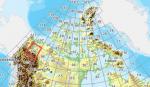
As Raimondo Taburet hasn't processed the CDED files above 60 degrees latitude for Canada, well here are the ones I have processed.
There isn't any data available from geobase in some of the blocks above 60 degrees latitude, these are blocks: 15, 17, 18, 28, 108, 109, 118, 119.
See jpg for coverage.
Thanks go to Geobase (Copyright) Canada for the availability & public use of this data.
Posted May 20, 2012 03:43 by Wayne Evans
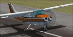
6.11Mb (592 downloads)
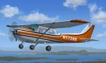
Textures for the default Cessna 172 in the fictional livery of N172RE. It is a orange Cessna 172 with some black. The livery and the tail number are fictional. There are instructions on how to install in the readme file. By Tyler Lawrence.
Posted May 19, 2012 19:19 by Tyler Lawrence
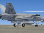
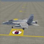
3.87Mb (458 downloads)
VFA-11 Red Rippers AC106 textures for the payware VRS Superbug
Posted May 19, 2012 16:22 by Chris Hammons
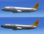
18.16Mb (2422 downloads)
2 Condor Boeing 737-300'sadapted from FS2004 Erik Cantu mopdel.
Complete model by Vista Liners / Erick Cantu is included. Added 737-300 2d Panel but no VC
Posted May 19, 2012 12:47 by Jim Fly
158.47Mb (410 downloads)
As Raimondo Taburet hasn't processed the CDED files above 60 degrees latitude for Canada, well here are the ones I have processed.
There isn't any data available from geobase in some of the blocks above 60 degrees latitude, these are blocks: 15, 17, 18, 28, 108, 109, 118, 119.
See jpg for coverage.
Thanks go to Geobase (Copyright) Canada for the availability & public use of this data.
Posted May 19, 2012 09:15 by Wayne Evans
44.77Mb (316 downloads)
As Raimondo Taburet hasn't processed the CDED files above 60 degrees latitude for Canada, well here are the ones I have processed.
There isn't any data available from geobase in some of the blocks above 60 degrees latitude, these are blocks: 15, 17, 18, 28, 108, 109, 118, 119.
See jpg for coverage.
Thanks go to Geobase (Copyright) Canada for the availability & public use of this data.
Posted May 19, 2012 08:42 by Wayne Evans
212.87Mb (363 downloads)
As Raimondo Taburet hasn't processed the CDED files above 60 degrees latitude for Canada, well here are the ones I have processed.
There isn't any data available from geobase in some of the blocks above 60 degrees latitude, these are blocks: 15, 17, 18, 28, 108, 109, 118, 119.
See jpg for coverage.
Thanks go to Geobase (Copyright) Canada for the availability & public use of this data.
Posted May 19, 2012 08:29 by Wayne Evans