


FSX > Page 1795
1.27Mb (6495 downloads)
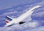
You are a captain of the famous Concorde registered in Air France colours. The flight is a routine return flight from Charles-de-Gaulle to John F. Kennedy iaw from John F. Kennedy to Charles-de-Gaulle that was on the daily flight schedule in the peak of the Concorde’s life before all the problems started. Interesting feature is the take-off at sunset and landing a few hours later after sunrise.
Posted Aug 13, 2009 08:25 by Robbie Albers
0.01Mb (7296 downloads)
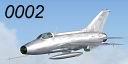
I saw this Mig-21 F-13 by Ivan Jurcaga with an amazing sound set and model. The VC is okay, but not fully clickable. I've been reworking .air files and .cfg files for a few demo teams and an Abacus add on pack and decided to do this for fun. It flies much more accurately than the default flight dynamics for the aircraft and I've changed everything from the flight dynamics themselves to the rate of animation and fuel flow.
Required files:
required file
Posted Aug 13, 2009 00:29 by John Corsi
2.34Mb (9120 downloads)
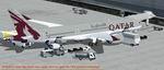
FSX Qatar Airbus A350-900 XWB V2. Versions 2 is an all new version of the A350-900 seen at the Paris Air Show 2009, with a new nose, new cockpit windows,new wings and winglets.
This CamSim Version 2 is also including an updated new Animated Ground Servicing (AGS).
Model design and paint by: Camil Valiquette
Posted Aug 12, 2009 18:13 by Camil Valiquette
4.98Mb (1560 downloads)
CYRC - Chicoutimi airport, Quebec, Canada
Chicoutimi Airport is located in Quebec, North west of CYQB and includes a NDB approach. It provides 3 runways in delta!
I have developped the apron and parking lot including multiple building that the original airport have. Wild life is around and a visual reference should help you find
that airport quite easily! :)
Hope you'll enjoy your stop over in Chicoutimi.
I have included the airport information and charts. By Daniel Louvet
Posted Aug 12, 2009 15:21 by Daniel Louvet
1.84Mb (694 downloads)
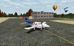
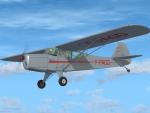
A repaint for the new freeware Auster Autocrat by Dave Garwood, representing F-PAGD. Repaint by Jan Kees Blom, based on the paintkit by Dave Garwood.
Available here (external site)
Posted Aug 12, 2009 01:38 by Jan Kees Blom
1.86Mb (707 downloads)
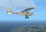
A repaint for the new freeware Auster Autocrat by Dave Garwood, representing PH-NFH, an aircraft that was owned by Frtits Philips of Philips electronics, before it was donated to the Aviodrome Museum in Lelystad, the Netherlands. Repaint by Jan Kees Blom, based on the paintkit by Dave Garwood.
Available here (external site)
Posted Aug 12, 2009 01:37 by Jan Kees Blom
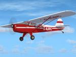
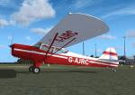
1.84Mb (1046 downloads)
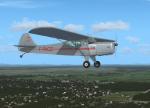
A repaint for the new freeware Auster Autocrat by Dave Garwood, representing G-AJRC. Repaint by Jan Kees Blom, based on the paintkit by Dave Garwood.
Available here (external site)
Posted Aug 12, 2009 01:32 by Jan Kees Blom
0.00Mb (3556 downloads)
A brief tutorial on how to do and ILS Landing.(Instrument Landing System)
Posted Aug 11, 2009 20:50 by Dakota
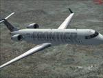
7.16Mb (3633 downloads)
This is a repaint the default CRJ-700 for Fsx. Repainted in the textures of Frontier Airlines.
Repaint By: James Landes- www.fsx-repaints.com
Posted Aug 11, 2009 15:45 by James Landes
0.00Mb (1420 downloads)
This is for people who wish to delete their FSX.cfg file but cant find it.
By Ian Bertolacci
Posted Aug 11, 2009 15:32 by Ian Bertolacci