


FSX > Page 1889
0.85Mb (7644 downloads)
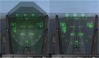
This package contains three different HUD glasses mods. It is intended for the Microsoft
Acceleration F/A-18 Hornet ONLY.
The purpose of this package is to give your F/A-18 a more realistic look by replacing its
HUD texture.
Very easy to install with my easy and detailed guide on how to do it
Posted Feb 11, 2009 04:06 by Enrico B
10.56Mb (6039 downloads)
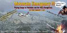
Pilots from the World Over fly for good "Mula" in the Mountains of all Asia. Captain Dakalm Sakalm from Tinbaktu, Pedro Diaz from Islas Rojitas, Roolf Wulfgang from Peru and many others make a bundle in two or three years ...or are never heard of again!!!!!!!...Flights here are not dull, ever!!!. Just a taste of what can happen anyday: Chief Monk, Kunko-Lambuka, of the Monastery of the Holy Monkey of Diamonds over in Zhet-Maluka, has flown to Gurgharkan to visit his maiden sister who is about to get married to Barkok Hulikun, an unknown, but very well spoken bar tender in Chikolan Village in the Zilikan Mountains. As his plane lands at the mountain airfield he finds that the pilot comes in too fast and (?)..........Meanwhile you are flying the bulky but strong F-123 full of resin oil drums to some new village up in Kundakar. So, since you are close to the mentioned site where the Monk went, you are diverted to it....see,it really is an Adventure flying around these windy mountains (Grandma told you so)....if you decide to take this flight make sure you have at least one or two short airfield landings and takeoffs......you will need them.----PS: If you have ever landed in Lukla---you will smile when you see Gurgharkan.--
Posted Feb 10, 2009 10:35 by Gera Godoy Canova
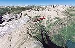
89.70Mb (3354 downloads)
FSX/FS2004 Glacier National Park, Babb Airport (49S), Montana (MT). Photoreal scenery package.
Covers the spectacular Glacier National Park just south of the Canadian border in
Montana. Although the mountains formed about 60 million years ago, the rugged landscape as we
see it today is largely the effect of glaciers. The covered area is 3500 sq km at 4.7 m/pixel
quality. By Gottfried Razek.
Required files:
required file
Posted Feb 10, 2009 06:13 by Gottfried Razek
40.47Mb (2737 downloads)
This scenery adds main the Sicilian Airfields, currently active. The zone of every airfield has been rendered photo realistic
and with autogen. Includes roads. Very detailed scenery. Little effects on frame rates..
The scenery does not have nocturnal effects.
Posted Feb 10, 2009 05:43 by Francesco Cerra
3.02Mb (6164 downloads)
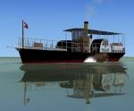
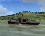
Ship for FSX and FS2004. Updated version for the side wheel paddle steamer SS Hjejlen. The complete ship model with 2-D panel, VC and effects is from Claus Vendelboe Holmberg. The modified panel configuration with 8 additional virtual deck views is from Erwin Welker.
You can ride on this beautyful old steamship as captain, standing on the helm in the wheelhouse, or you can enjoy a ride as passenger, beeing on the foreship, beside the wheels or at the stern.
Posted Feb 10, 2009 00:58 by Erwin Welker

1.08Mb (424 downloads)
Flightdeck S-3 Viking textures only in VS-41 Clover colors
Posted Feb 9, 2009 22:44 by FSXF Rhino
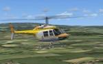
1.36Mb (1176 downloads)
Textures for the default B206. Instantly recognisable as the helicopter used to ferry Anneka Rice
and Annabel Croft around the countryside in seven series of Treasure Hunt on the UK Channel 4 station.
G-BHXU was to perform a much smaller role in Interceptor.
This aircraft retained the same registration throughout its life from 1981 until its sad
demise in 1995. The livery remained reasonably consistent as well.
Exceptions - a picture that was on the Castle Air website indicated that the dark brown areas were once black and in later years it was repainted entirely white for an episode of "Wycliffe" in which the pilot Keith Thompson had a role as a Police pilot.
Textures for FSX by James Ewins
Posted Feb 9, 2009 09:53 by James Ewins
19.38Mb (6133 downloads)
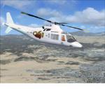
061 Medical Service Malaga, Spain, Textures for Alan Devins' FS2004 Gmax Agusta A109a and the FSX updated version by Danny Garnier.
FSX Version here: http://www.simviation.com/simviation/static.php?ID=65&page=5
Original Package here:
Required files:
required file
Posted Feb 9, 2009 09:36 by Carlos del Olmo
8.67Mb (3260 downloads)
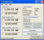
FS98 - FSX FS Real Time v1.88.1 is made to
keep Flight Simulator's UTC (Zulu/GMT) time
and date in sync with the Real World. It can
maintain either the current Real Time, or an
offset (+/-) so you can fly at any variation
from Real Time. This package also includes
a new set of World Time Zones scenery files
which eliminate many of the time zone errors
that shipped with recent versions of Flight
Simulator. FS Real Time by Joshua Robertson.
Posted Feb 9, 2009 07:42 by Joshua Robertson
0.99Mb (397 downloads)
Textures only for the Flight Deck 5 S-3 Viking in VS-41 colors
Posted Feb 9, 2009 05:17 by FSXF Rhino