


FSX > Page 1890
91.72Mb (874 downloads)
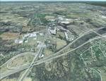
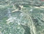
FSX Louisville PhotoReal Scenery
This is high resolution, 1Meter/Pixel, terrain scenery for Louisville, Ky. This section, J, features Buckner, KY at the I71 split. This photoscenery is for DAY USE ONLY and will work for any season, but shows only the USGS aerial photo data taken in April 2002. The default FSX mesh works well with this photoscenery and no additional mesh for the area needs to be purchased. This scenery was designed to work with an earlier release of FSX 3D scenery available on this site named LouFX0R and LouFX1R.
By Jim Jones.
Required files:
required file
Posted Feb 8, 2009 12:18 by Jim Jones
9.10Mb (8844 downloads)
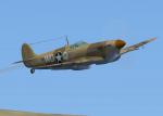
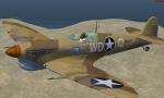
Fs2004/FSX Spitfire MK V B Tropical. The Mk VB(trop) (or type 352) could be identified by the large Vokes air filter fitted under the nose; the reduced speed of the air to the supercharger had a detrimental effect on the performance of the aircraft, but the decreased performance was considered acceptable. Many were sent overseas, with the majority of them being used either in North Africa and the Mediterranean or in the Far East.rnTotal production was 6,487. Original CFS2 mdl by Brunosk, textures by Sopwith Chameleon. Upgraded to FS9/FSX by A.F.Scrub
Posted Feb 8, 2009 12:16 by A.F.Scrub
54.66Mb (937 downloads)
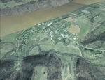
FSX Louisville PhotoReal Scenery
This is high resolution, 1Meter/Pixel, terrain scenery for Louisville, Ky. This section, E, features Westport, KY and east Clark County, Indiana. This photoscenery is for DAY USE ONLY and will work for any season, but shows only the USGS aerial photo data taken in April 2002. The default FSX mesh works well with this photoscenery and no additional mesh for the area needs to be purchased. This scenery was designed to work with an earlier release of FSX 3D scenery available on this site named LouFX0R LouFX1R.
By Jim Jones.
Posted Feb 8, 2009 11:59 by Jim Jones
91.33Mb (835 downloads)
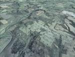
FSX Louisville PhotoReal Scenery
This is high resolution, 1Meter/Pixel, terrain scenery for Louisville, Ky. This section, DD, features Mc Neely Park, KY. This photoscenery is for DAY USE ONLY and will work for any season, but shows only the USGS aerial photo data taken in April 2002. The default FSX mesh works well with this photoscenery and no additional mesh for the area needs to be purchased. This scenery was designed to work with an earlier release of FSX 3D scenery available on this site named LouFX0R and LouFX1R.
By Jim Jones.
Posted Feb 8, 2009 10:18 by Jim Jones
57.08Mb (833 downloads)
FSX Louisville PhotoReal Scenery
This is high resolution, 1Meter/Pixel, terrain scenery for Louisville, Ky. This section, D, features Runyantown Indiana and sections of the Indiana Arsenal. This photoscenery is for DAY USE ONLY and will work for any season, but shows only the USGS aerial photo data taken in April 2002. The default FSX mesh works well with this photoscenery and no additional mesh for the area needs to be purchased. This scenery was designed to work with an earlier release of FSX 3D scenery available on this site named LouFX0R and LouFX1R.
By Jim Jones.
Posted Feb 8, 2009 10:00 by Jim Jones
92.04Mb (936 downloads)
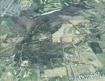
FSX Louisville PhotoReal Scenery
This is high resolution, 1Meter/Pixel, terrain scenery for Louisville, Ky. This section, CC, features Mount Washington, KY. This photoscenery is for DAY USE ONLY and will work for any season, but shows only the USGS aerial photo data taken in April 2002. The default FSX mesh works well with this photoscenery and no additional mesh for the area needs to be purchased. This scenery was designed to work with an earlier release of FSX 3D scenery available on this site named LouFX0R and LouFX1R.
By Jim Jones.
Posted Feb 8, 2009 07:51 by Jim Jones
58.68Mb (970 downloads)
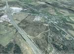
FSX Louisville PhotoReal Scenery
This is high resolution, 1Meter/Pixel, terrain scenery for Louisville, Ky. This section, C, features Memphis Indiana and nearby I65. This photoscenery is for DAY USE ONLY and will work for any season, but shows only the USGS aerial photo data taken in April 2002. The default FSX mesh works well with this photoscenery and no additional mesh for the area needs to be purchased. This scenery was designed to work with an earlier release of FSX 3D scenery available on this site named LouFX0R and LouFX1R.
By Jim Jones.
Posted Feb 8, 2009 07:34 by Jim Jones
61.67Mb (859 downloads)
FSX Louisville PhotoReal Scenery
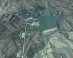
This is high resolution, 1Meter/Pixel, terrain scenery for Louisville, Ky. This section, B, features Deam Lake in Indiana. This photoscenery is for DAY USE ONLY and will work for any season, but shows only the USGS aerial photo data taken in April 2002. The default FSX mesh works well with this photoscenery and no additional mesh for the area needs to be purchased. This scenery was designed to work with an earlier release of FSX 3D scenery available on this site named LouFX0R and LouFX1R.
By Jim Jones.
Posted Feb 8, 2009 06:45 by Jim Jones
58.47Mb (971 downloads)
FSX Louisville PhotoReal Scenery
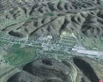
This is high resolution, 1Meter/Pixel, terrain scenery for Louisville, Ky. This section, A, features New Providence Indiana. This photoscenery is for DAY USE ONLY and will work for any season, but shows only the USGS aerial photo data taken in April 2002. The default FSX mesh works well with this photoscenery and no additional mesh for the area needs to be purchased. This scenery was designed to work with an earlier release of FSX 3D scenery available on this site named LouFX0R and LouFX1R.
By Jim Jones.
Posted Feb 8, 2009 06:42 by Jim Jones
6.86Mb (5076 downloads)
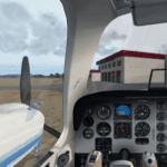
ENGLISH VERSION.You may think that one flight from Pamplona ( Spain) to Huesca, is easy.But when you have to take photos near ground, and your plane is a little old! This flight would be a challenge! Will you accept it? Requires FSX Acceleration.
Posted Feb 7, 2009 14:10 by Jose Enrique Ariño