


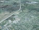
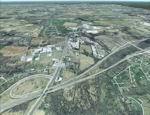
91.34Mb (782 downloads)
FSX Louisville PhotoReal Scenery
This is high resolution, 1Meter/Pixel, terrain scenery for Louisville, Ky. This section, II, features the South edge of the scenery. This photoscenery is for DAY USE ONLY and will work for any season, but shows only the USGS aerial photo data taken in April 2002. The default FSX mesh works well with this photoscenery and no additional mesh for the area needs to be purchased. This scenery was designed to work with an earlier release of FSX 3D scenery available on this site named LouFX0R and LouFX1R.
By Jim Jones.
Posted Feb 12, 2009 07:03 by Jim Jones
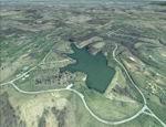
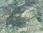
77.54Mb (783 downloads)
FSX Louisville PhotoReal Scenery
This is high resolution, 1Meter/Pixel, terrain scenery for Louisville, Ky. This section, GG, features Long Run Park. This photoscenery is for DAY USE ONLY and will work for any season, but shows only the USGS aerial photo data taken in April 2002. The default FSX mesh works well with this photoscenery and no additional mesh for the area needs to be purchased. This scenery was designed to work with an earlier release of FSX 3D scenery available on this site named LouFX0R and LouFX1R.
By Jim Jones.
Posted Feb 12, 2009 06:22 by Jim Jones
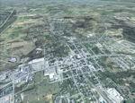
73.05Mb (946 downloads)
FSX Louisville PhotoReal Scenery
This is high resolution, 1Meter/Pixel, terrain scenery for Louisville, Ky. This section, EE, features LaGrange KY and the WAVE TV tower. This photoscenery is for DAY USE ONLY and will work for any season, but shows only the USGS aerial photo data taken in April 2002. The default FSX mesh works well with this photoscenery and no additional mesh for the area needs to be purchased. This scenery was designed to work with an earlier release of FSX 3D scenery available on this site named LouFX0R and LouFX1R.
By Jim Jones.
Posted Feb 11, 2009 04:47 by Jim Jones
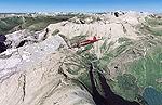
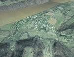
89.70Mb (3352 downloads)
FSX/FS2004 Glacier National Park, Babb Airport (49S), Montana (MT). Photoreal scenery package.
Covers the spectacular Glacier National Park just south of the Canadian border in
Montana. Although the mountains formed about 60 million years ago, the rugged landscape as we
see it today is largely the effect of glaciers. The covered area is 3500 sq km at 4.7 m/pixel
quality. By Gottfried Razek.
Required files:
required file
Posted Feb 10, 2009 06:13 by Gottfried Razek

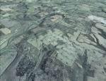
40.47Mb (2737 downloads)
This scenery adds main the Sicilian Airfields, currently active. The zone of every airfield has been rendered photo realistic
and with autogen. Includes roads. Very detailed scenery. Little effects on frame rates..
The scenery does not have nocturnal effects.
Posted Feb 10, 2009 05:43 by Francesco Cerra
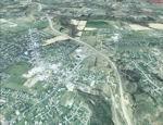
91.72Mb (874 downloads)
FSX Louisville PhotoReal Scenery
This is high resolution, 1Meter/Pixel, terrain scenery for Louisville, Ky. This section, J, features Buckner, KY at the I71 split. This photoscenery is for DAY USE ONLY and will work for any season, but shows only the USGS aerial photo data taken in April 2002. The default FSX mesh works well with this photoscenery and no additional mesh for the area needs to be purchased. This scenery was designed to work with an earlier release of FSX 3D scenery available on this site named LouFX0R and LouFX1R.
By Jim Jones.
Required files:
required file
Posted Feb 8, 2009 12:18 by Jim Jones
54.66Mb (937 downloads)
FSX Louisville PhotoReal Scenery
This is high resolution, 1Meter/Pixel, terrain scenery for Louisville, Ky. This section, E, features Westport, KY and east Clark County, Indiana. This photoscenery is for DAY USE ONLY and will work for any season, but shows only the USGS aerial photo data taken in April 2002. The default FSX mesh works well with this photoscenery and no additional mesh for the area needs to be purchased. This scenery was designed to work with an earlier release of FSX 3D scenery available on this site named LouFX0R LouFX1R.
By Jim Jones.
Posted Feb 8, 2009 11:59 by Jim Jones
91.33Mb (835 downloads)
FSX Louisville PhotoReal Scenery
This is high resolution, 1Meter/Pixel, terrain scenery for Louisville, Ky. This section, DD, features Mc Neely Park, KY. This photoscenery is for DAY USE ONLY and will work for any season, but shows only the USGS aerial photo data taken in April 2002. The default FSX mesh works well with this photoscenery and no additional mesh for the area needs to be purchased. This scenery was designed to work with an earlier release of FSX 3D scenery available on this site named LouFX0R and LouFX1R.
By Jim Jones.
Posted Feb 8, 2009 10:18 by Jim Jones
57.08Mb (833 downloads)
FSX Louisville PhotoReal Scenery
This is high resolution, 1Meter/Pixel, terrain scenery for Louisville, Ky. This section, D, features Runyantown Indiana and sections of the Indiana Arsenal. This photoscenery is for DAY USE ONLY and will work for any season, but shows only the USGS aerial photo data taken in April 2002. The default FSX mesh works well with this photoscenery and no additional mesh for the area needs to be purchased. This scenery was designed to work with an earlier release of FSX 3D scenery available on this site named LouFX0R and LouFX1R.
By Jim Jones.
Posted Feb 8, 2009 10:00 by Jim Jones
92.04Mb (936 downloads)
FSX Louisville PhotoReal Scenery
This is high resolution, 1Meter/Pixel, terrain scenery for Louisville, Ky. This section, CC, features Mount Washington, KY. This photoscenery is for DAY USE ONLY and will work for any season, but shows only the USGS aerial photo data taken in April 2002. The default FSX mesh works well with this photoscenery and no additional mesh for the area needs to be purchased. This scenery was designed to work with an earlier release of FSX 3D scenery available on this site named LouFX0R and LouFX1R.
By Jim Jones.
Posted Feb 8, 2009 07:51 by Jim Jones