


FSX > Page 1252
21.41Mb (4007 downloads)
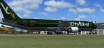
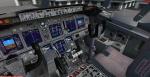
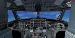
Boeing 767-300ER CityBird Livery.
Upgraded to FSX using Alrot's revised Boeing 737-800 VC. This model includes Working wipers (right mouse click on switch) with rain effect. Switches for LCD Screens, EICAS, PFD, MFT. Autobrake switch. Opening pilots window. Cabin Lights switch. Realistic FMC. Ground Proximity Warning System (GPWS), More Realistic night textures. Model features High resolution textures, Dynamic flexing wings, Body gear steering, Nose gear steering, Rudder lock, Ground spoilers, Low speed aileron locks at high speed, Fully animated control surfaces, Fully independent suspension, Trim Animation, Opening Passenger Doors, Animated tilting bogies, Rolling wheels, Animated thrust reverser's with reverser block doors, Detailed textures, Full night lighting, Crash affects, Ground Service Vehicles (Activate under Views-Instrument panel - Posky Utilities).. Model Designer Hiroshi Igami/Yosuke Ube. Flight Dynamics Designer Warren C. Daniel. High quality repaint by Febriant Leocesio.
FSX native model by Skyspirit. VC by Alejandro Rojas Lucena (Alrot).
Modified for FSX by Chris Evans.
Posted Jun 27, 2012 08:42 by Chris Evans
15.97Mb (1035 downloads)
Swiss Breitling textures for the Team 1049 Lockheed_L1049G package. These are made after the scheme of a restored Connie. Painted by Chris Snell. Also includes vc textures.
Required files:
required file
Posted Jun 26, 2012 21:11 by Chris Snell
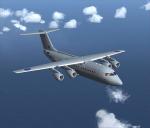
5.82Mb (10300 downloads)
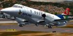
Complete package for FSX. This model represents ZE708, one of two
refurbished BAE 146-200's purchased by the Royal Air Force in April
2012 to supplement the transport capability of the RAF. The aircraft was
originally manufactured in 1991 and passed through the hands of several
airlines until 2012 when it was refurbished by BAE Systems and
converted to military configuration. Package includes custom panel and VC
Model, panels & FD by Premier Aircraft Design. RAF paint by Stephanie Lawton.
Posted Jun 26, 2012 10:56 by Bob May (PAD)
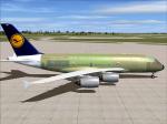
29.44Mb (4743 downloads)
Project Airbus A380 Lufthansa F-WWAK in Airbus Industrie factory colors. Includes VC for FSX.
Posted Jun 26, 2012 10:32 by Jim Fly
26.63Mb (2679 downloads)
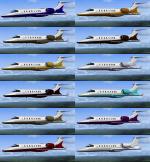
These new Textures are for the default FSX Lear 45 Jet. This File contains 11 new colors and 1 Project Texture. All are in high resolution BMP Textures. Download Includes a easy to use step by step with illustrations. Textures by Mark " Fireball " Rooks
Posted Jun 26, 2012 00:45 by Mark Rooks
20.80Mb (2135 downloads)
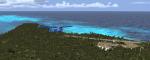
Juan de Nova Island (French: locally Ile Juan de Nova or officially Ile Juan da Nova), also known as Saint-Christophe, is a 4.4 square kilometres (1.7 sq mi) low, flat, tropical island in the narrowest part of the Mozambique Channel, about one-third of the way between Madagascar and Mozambique. This is where five oil rigs are looking for oil. Once a year the 'rig guys' get a week of vacation to Mozambique or Madagascar 'Caguachatti Oil Rest Camps'. You are one of the pilots who flies them there and returns them after the 'Boosy week' as it is called. No time to waste pilots get on with the job. Warning: Very hard!! for pilots with both twin engine and helicopter Licenses Only!!
Posted Jun 25, 2012 16:25 by Gera Godoy Canova
10.50Mb (498 downloads)
Airlink textures only for the payware PMDG BAE JS4100
Posted Jun 25, 2012 10:23 by Trino Jose Rojas Mora

3.93Mb (1181 downloads)
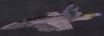
Enclosed is a FSXTipline repaint showing the 2012 VAQ-130 Zappers CAG scheme of the Team KBT Growler. Special thanks to TwoBobs Decals & VAQ-130 Zappers.
Work by Josef A. Kunzlar of FSXTipline.blogspot.com.
Required files:
required file
Posted Jun 25, 2012 05:52 by Josef A. Kunzlar of FSXTipline
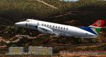
31.82Mb (10172 downloads)
Rick Piper's beautiful and classic Hawker Siddeley HS748 repainted for FSX in Air
North current livery. Comprehensive high quality VC included as well as high detail model.
Air North is a Canadian airline flying in the north Yukon area. Textures by Stephen Browning
Posted Jun 25, 2012 02:25 by Stephen Browning
50.26Mb (7520 downloads)
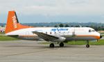
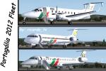
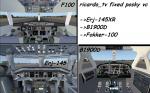
Portugalia aircraft fleet 2012. This package includes 3 complete aircraft packages - the Beech-1900D, Erj-145 and F-100. Models by Posky & Premier Aircraft.
About this airline: when it was an independent company its head office was in Building 70 on the grounds of Portela Airport in Lisbon. It operates scheduled international and domestic services from Lisbon and Porto, as well as European charter services, since 2007 exclusively under TAP flight codes.
Textures by ricardo_tv.
Posted Jun 24, 2012 16:46 by ricardo_tv