


FSX > Page 1254
1.23Mb (1099 downloads)
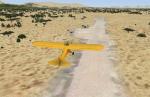
Photoreal Scenery of Jeki Airstrip.
The airstrip is located in Zambia at Lower Zambezi National Park and mainly used to bring tourists and game hunters into the park. It is also commercially used by Proflight Zambia.
For FSX only!
Posted Jun 21, 2012 14:23 by Jens Weissflog
10.50Mb (641 downloads)
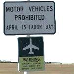
Copalis State Airport (FAA LID: S16) for Orbx FTX PNW, formerly Copalis Beach State Airport, is located on the beach near Copalis Beach, in Grays Harbor County, Washington, United States. It is the only airport in the United States that is located on an ocean beach.
The runway is the 4,500-foot (1,400 m) stretch of ocean beach from the Copalis River on the south to the rocks a mile north. It is only available during low tide. (from wikipedia) This Addon for FSX requires Orbx PNW (the KHQM demo or the full fledged region )
Posted Jun 21, 2012 01:47 by etien
19.16Mb (4552 downloads)
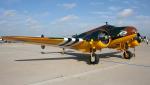
This is the Simtech Beechcraft C45G KJ508 Is Privately owned but painted in Royal Air Force D-Day livery. VC (Edited for FSX by Danny Garnier) plus I've taken out the Mip Maps for a sharper look. Painted by Stephen Browning
Posted Jun 20, 2012 16:26 by Stephen Browning
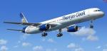

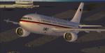
69.65Mb (21511 downloads)
Boeing 757-300 painted in the Thomas Cook colors. Textures by Posky team. Model by Project Opensky. Custom B757 sounds. Panel mods for FSX by Sanjay Blair.
Posted Jun 20, 2012 06:44 by Mohd
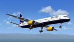
68.72Mb (10701 downloads)
Boeing 757-300 painted in the IcelandAir colors. Textures by Posky team. Model by Project Opensky. Custom B757 sounds. Panel mods for FSX by Sanjay Blair.
Posted Jun 20, 2012 06:42 by Mohd
1.03Mb (1254 downloads)
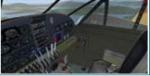
Operations Manual for the simtech Beech 18/C45 model recently upgraded to be used in FSX. This manual is necessary to properly start the engines after shutdown, etc.
Posted Jun 19, 2012 12:41 by uploader
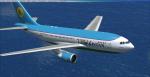
222.84Mb (24678 downloads)
Done! The Airbus A310 series Multi-Livery Mega-Package is now available! This package contains all the A310 series models, created by Thomas Ruth, custom VIRTUAL COCKPITS and panels for each variant of the A310 (also created by Mr. Ruth), CUSTOM SOUNDPACKS for the GE and the PW engines (created by Mike Maarse), 12 different liveries, a fully edited aircraft.cfg with 27 CUSTOM-MADE VIEWS THROUGHOUT THE ENTIRE AIRCRAFT, and a lot of time and dedication! For more Information of this package, images and a extended explanation in English and Spanish, visit my blog at: http://fsxluchoals.blogspot.com/
Posted Jun 19, 2012 02:56 by Luis Quintero
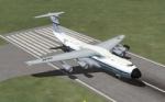
0.09Mb (2010 downloads)
Views ( defined by camera definitions in the aircraft.cfg file ) for the beautiful Lockheed C-5A Galaxy. Original model by Kazunori Ito.
Unfortunatly there are no VC.
13 cameras pointing at the aircraft, 1 in the cargo bay and a total of 3 views in the virtual cockpit.
See Read me.txt file for very easy installation procedures.
And finally two more files - Available.pdf and Top 20.pdf for informations about my "camera definitions" packages.
Required files:
required file
Posted Jun 19, 2012 02:02 by Marc Renaud
0.00Mb (116 downloads)
This is a fix for v2 of my Overland SMS gauges upgrade pack, and in particular for the A340. It fixes the clock which did not show up in 2d and VC modes.
Required files:
required file
Posted Jun 18, 2012 16:58 by Dimitrios Moschos
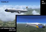
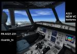
65.19Mb (3730 downloads)
This is the Project Airbus A321-132 Lufthansa Retro or Retrojet liner. Celebrating the 50th year of traveling in Instanbul and for the recording the old airliner colours.
Textures & model by PA. Packed and add new VC textures & update by ricardo_tv.
Enjoy
Posted Jun 18, 2012 15:32 by ricardo_tv