


FSX > Page 1253
0.10Mb (2858 downloads)
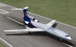
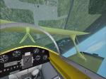
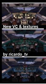
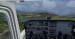
Reworked and additionnal views ( defined by camera definitions in the aircraft.cfg file ) for
the "Tupolev Tu-154 V1 package". Original model by team Project Tupolev. Panel and additionnal
textures by Ricardo_tv. VC cockpit by Thomas Ruth (B727-200).
11 outside views of the aircraft and a total of 7 virtual cockpit views.
See Read me.txt file for very easy installation procedures.
Also included is a text file that contains the new camera definitions.
Enjoy !
Required files:
required file
Posted Jun 24, 2012 16:12 by Marc Renaud
3.60Mb (1462 downloads)
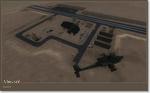
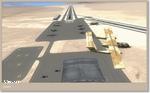
KCBF - Bluffs Municipal Airfield, Iowa, V2.
Modeled after Google Earth images.
All ILS, GPS, and VOR approaches are real world.
With AI traffic. All scenery objects are FSX default except for the apron lights.
Posted Jun 24, 2012 13:29 by T.Marson
3.37Mb (7474 downloads)
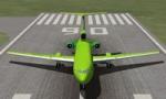
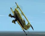
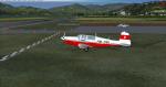
This is Jim Leroy's wonderful Pitts Bulldog. Improved flight dynamics, smoke for improved realism. Original model by M Miemi. Revamp by Virtual Aerobatics Unlimited.
Posted Jun 24, 2012 04:42 by vau
51.40Mb (6224 downloads)
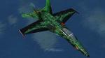
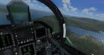
FSX Acceleration EasternHops Dragon Theme F-18. This is the default FSX Acceleration F/A-18 full model. Requires FSX Acceleration for the aircraft to work.
Posted Jun 23, 2012 18:35 by Robert D
0.01Mb (1059 downloads)
Two fictional military airfields in Death Valley CA. Created with Michael Carr's Military Object Library. (extra file required -- see file for details)
Posted Jun 22, 2012 20:28 by Chuck79
35.96Mb (27542 downloads)
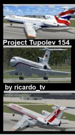
The Tupolev Tu-154 is a three-engine medium-range narrow-body airliner designed in the mid 1960s and manufactured by Tupolev.
Russian airlines for several decades, it serviced over a sixth of the world's landmass and carried half of all passengers flown by Aeroflot and its subsidiaries (137.5 million/year or 243.8 billion passenger kilometers in 1990).
With a cruising speed of 975 kilometres per hour (606 mph), the Tu-154 is one of the fastest civilian aircraft in operation and has a range of 5,280 kilometres (3,280 mi).
This package is the ProjectTupolev 154B-2 modified and added a simple and easy Panel to fly, very familiar to use with realistic textures from original by ricardo_tv.
Textures made by ricardo_tv (most) & Air Force by PT Tu-154.
Have Russian Air Force, Polish Air Force, American, Aeroflot (New), Air France, British, Cubana, Interflug, Lufthansa, LOT, Siberia S7 and UTair. Have fun
Posted Jun 22, 2012 12:03 by ricardo_tv
12.64Mb (1640 downloads)
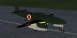
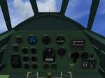
Nakajima Kikka was developed late in World War II. The first prototype had only flown once before the end of the conflict. This model comes with VC and 3D Gauges, and was compiled with FSX SDK SP2.
Posted Jun 22, 2012 11:39 by Hadi Tahir & Harri Thaha
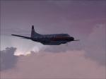
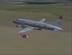
2.09Mb (779 downloads)
Textures for the CalClassic Convair CV-580 in the livery of the Conair air tanker C-GYXC (Tanker 42).
Required files:
required file
Posted Jun 22, 2012 02:38 by Grant Dunbar
1.31Mb (1223 downloads)
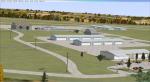
FSX Scenery--Wangen-Lachen Airfield (LSPV), Switzerland. Wangen-Lachen is a small airfield ideal for excursions to the Swiss mountain range on a single or twin engine machine. It's an enhancement of the neglected FSX scenery with mostly standard objects. Needed library is included. Surroundings also realized according to Google satellite imagery. Also adds some marinas, which are there in the real world and help you to line up with the runway but also are a hazard. Also included is boat traffic on the lakes of Zurich with some piers. The scenery is compatible with UTX Europe and FSGUX (Mesh). But since LSPV is pretty flat, the scenery should be compatible with standard mesh too. By Blaunarwal.
Posted Jun 21, 2012 16:53 by Blaunarwal
4.74Mb (706 downloads)
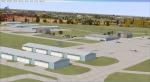
The airport is located 15km west of Kasama the provincial capital city of Northern Province Zambia. It is used commercially by Proflight Zambia but also private.
This photoreal Scenery has been made without adding a FSX default runway. The Runway is bumpy and is not flat at all. Finding the airport shouldn't be a problem. Only Runway 13/31 is used.
FSX only!
Posted Jun 21, 2012 14:58 by Jens Weissflog