


FSX > Page 1257
(1505 downloads)
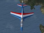
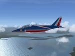
FSX/FS2004 Alphajet Patrouille de France No.1 textures only. Patrouille de France is the aerobatic demonstration team of the French Air Force. Requires the original model by LCO, JP Bourgeois, Jean-Pierre Langer, Jean-Pierre Bourgeois, Benoit M. Dube
Required files:
required file
Posted Jun 13, 2012 01:34 by PhilippeKREH
19.21Mb (9130 downloads)
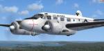
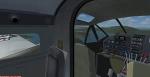
(Window transparency fixed!) FSX Beechcraft C-45G "Expediter" USAF
A complete redesign by Cliff Presley that converts
simTECH Flight Design's FREEWARE Beech 18 into a
fabulous, photo realistic delineation of a USAF C-45
"Expediter." 500 man hours went into the new textures
and upgraded interior, engine detail, and reconfigured
flight crew. It also includes a sound system by Des
Braban, instrument panel by Fred Choate, and revised
aircraft.cfg file by John de Giorgio that makes this
beauty fly the way she was supposed to. Converted to FSX by Danny Garnier. Textures and panel edits.
Posted Jun 12, 2012 13:22 by Garnier D
7.21Mb (5463 downloads)
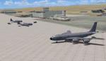
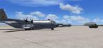
Edwards AFB, California, Ground Additions
This Scenery Addition is an unofficial Update for the Acceleration Pack Edwards AFB Scenery.
It adds 2 Refuel Stations, Static KC-135 Tanker, Static F-15C, Static A-10, Static Predator, Static C-130 Hercules.
Posted Jun 12, 2012 07:54 by uploader
86.32Mb (3647 downloads)
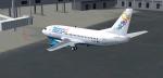
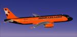
FSX 737-500 new Bahamas Air (C6-BFE) and New Xtra Airlines Bahamasair that has services to KBWI, KRDU, KRIC, KSDF. Painted by BahamasFlyers. Original model by Eric Cantu/FFX adapted for FSX. (No VC.)
Posted Jun 11, 2012 23:26 by Shawn Penn
11.94Mb (365 downloads)
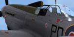
This is a repaint for the payware Wings of Power 3 P-51D Mustang by A2A Simulations. The skin depicts personal plane of the last CO of 303 (Polish) Squadron, S/L Witold Lokuciewski. Repaint was done using superb paintkit by Martin Catney (A2A)
Posted Jun 11, 2012 15:17 by Lukasz Kubacki
31.76Mb (1606 downloads)
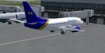
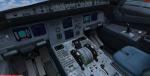
Project Airbus Donbassaero A320 UR-DAB for FSX. Donbassaero is an airline with its head office in Donetsk International Airport in Donetsk, Ukraine.
Includes default VC, upgraded by Jim Fly and great custom Airbus A320 sounds.
Posted Jun 11, 2012 13:48 by Jim Fly
33.24Mb (4941 downloads)
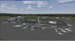
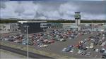
Quebec Jean Lesage International Airport (CYQB), Canada, v3.0. Includes terminal building, very accurate AFCAD, les Ailes Quebecoises, hangar AeroPro, hangar Essor Helicopteres, main security gate, taxi station, Air Canada Cargo buildings, fire station, aerocenter, hangar PetroT FBO, lighting on apron 1 and 2, antennas with strobe lights and red lights on mount Belair, hangar Trans-Sol FBO, Avitair-Jazz, Service Aerien Gouvernement du Quebec buildings, hangar Canadian Helicopters, Exeltech, Navcanada installation including the control tower, Groupe Alta, hangar Heli Express, maintenance installation buildings, new hangar for Trans-Sol FBO, parking exit cashier, Aqta Association Quebecoise des Transporteurs Aerien, Batiment des Gens de l'Air, airport administration building, fuel depot, les Cuisine de l'Air catering, fuel pump PetroT, static aircraft, ambulance. By Gilles Boily.
Posted Jun 11, 2012 06:40 by uploader
15.03Mb (8823 downloads)
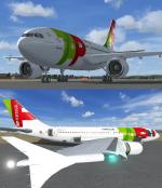
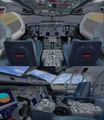
Model & VC by Thomas Ruth, textures & packed by ricardo_tv.
The Airbus A310 is a medium- to long-range twin-engined widebody jet airliner. Launched in July 1978, it was the second aircraft to enter production by Airbus Industrie, the consortium of European aerospace companies which is now owned by EADS.
Posted Jun 10, 2012 22:00 by ricardo_tv
4.49Mb (1904 downloads)
FSX Alternative grass textures. To install, copy the detail1.bmp to your FSX SceneryWorldTexture folder. Please ensure you backup your original detail1.bmp file.
Posted Jun 10, 2012 13:37 by uploader
17.15Mb (482 downloads)
Comes with complete Photoreal Scenery and Basic Autogen. Also includes a New AFCAD to suit the Photoreal Scenery. Nauru, in the south Pacific NE of Australia, is the world's smallest republic, covering just 21 square kilometres (8.1 sq mi). With just over 9,322 residents, it is the second least-populated country after Vatican City
I have not done any work on the Airport and will leave that for someone else to do.
If you make a New Airport please feel free to include this Scenery with your project and permission is not needed and you may do with this scenery anything you like except make money from it !!
Posted Jun 10, 2012 11:57 by Petro Lambert