


FSX > Page 1259
7.98Mb (1857 downloads)
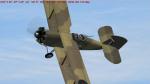
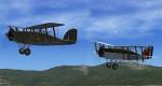
FSX/FS2004 Westland Wapiti MkI and MkIII
In 1926 the Air Ministry looked for a replacement for the long serving D.H 9A to fill the role of general-perpose aircraft for the RAF. Westland, who had been producing the D.H 9A on a sub-contract basis decided to offer a plane using parts of the D.H 9 . Although the fuselage was an entirely new design, the wings and interplane struts were from the old 9A. This design was named the Wapiti . At the outbreak of WWII several machine were still serving in the Middle East and saw limited active service . This is a new MkIII model with added gun and a MkI with upgraded textures.
GMAX model by A.F.Scrub
Posted Jun 7, 2012 18:03 by A.F.Scrub
1.09Mb (3414 downloads)
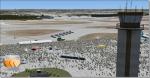
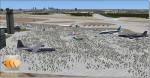
Dobbins AFB with airshow scenery. Dobbins Air Force Base is located in Marietta, GA, United States and is home to a Lockheed-Martin F-22 and C-130 factory. When I saw how many people had downloaded my last version I knew I had to make it better and more detailed. The scenery was created with Airport Design Editor (ADE) and Abacus's Scenery Shortcut program. This is only my second scenery build uploaded to the web and I would like to dedicate this to all our American service men and women; now and throughout history!
Posted Jun 7, 2012 14:45 by Joshua Keaton
20.48Mb (433 downloads)
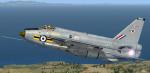
RAF Lightning TTF textures only for the payware Justflight Lightning. By UKMil.
Posted Jun 7, 2012 09:11 by UKMIL
9.93Mb (355 downloads)
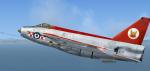
RAF Lightning 56 Sqn textures only for the payware Justflight Lightning. By UKMil.
Posted Jun 7, 2012 08:58 by UKMIL
9.34Mb (289 downloads)
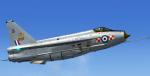
RAF Lightning 65 Sqn textures only for the payware Justflight Lightning. By UKMil.
Posted Jun 7, 2012 08:45 by UKMIL
7.51Mb (289 downloads)
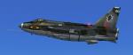
RAF Lightning 11 Sqn textures only for the payware Justflight Lightning. By UKMil.
TEXTURES BY ukmil[HTTP://WWW.UKMIL.ORG.UK]
Posted Jun 7, 2012 08:35 by UKMIL
3.07Mb (2498 downloads)
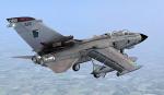
FSX Royal Air Force Tornado 617 Sqn photoreal textures
Photoreal textures for 617 SQN RAF Lossiemouth in the UK.
Requires the freeware Tornado by ukmil Textures by ukmil
Required files:
required file
Posted Jun 7, 2012 08:22 by UKMIL
3.60Mb (1078 downloads)
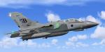
FSX Royal Air Force Tornado GR4 2 Sqn Photoreal textures.
Photoreal textures for 2 SQN RAF Marham
Requires the freeware Tornado by ukmil Textures by ukmil
Required files:
required file
Posted Jun 7, 2012 08:17 by UKMIL
2.95Mb (705 downloads)
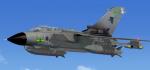
FSX Royal Air Force Tornado GR4 9 Sqn Photoreal textures.
Photreal textures for 9 SQN RAF Marham
Requires the freeware Tornado by ukmil Textures by ukmil
Required files:
required file
Posted Jun 7, 2012 08:13 by UKMIL
3.05Mb (1033 downloads)
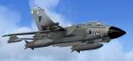
Fsx Royal Air Force Tornado GR4 2 sqn photoreal textures. This pack includes photreal textures for 2 sqn RAF Marham (UK) Requires the freeware Tornado by ukmil Textures by ukmil
Required files:
required file
Posted Jun 7, 2012 08:10 by UKMIL