


FSX > Page 1258
59.19Mb (11930 downloads)
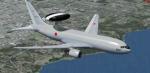
Japan Air-Self Defence Force Boeing E-767 84-3504.
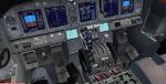
Upgraded to FSX using Alrot's revised Boeing 737-800 VC. This model includes Working
wipers (right mouse click on switch) with rain effect. Switches for LCD Screens, EICAS,
PFD, MFT. Autobrake switch. Opening pilots window. Cabin Lights switch. Realistic FMC.
Ground Proximity Warning System (GPWS), More Realistic night textures. Model features
High resolution textures, Dynamic flexing wings, Body gear steering, Nose gear
steering, Rudder lock, Ground spoilers, Low speed aileron locks at high speed, Fully
animated control surfaces, Fully independent suspension, Trim Animation, Opening
Passenger Doors, Animated tilting bogies, Rolling wheels, Animated thrust reverser's
with reverser block doors, Detailed textures, Full night lighting, Crash affects,
Ground Service Vehicles And more. Included custom Boeing 767 sounds!
Painted by Yosuke Ube
FSX native model by Skyspirit. VC by Alejandro Rojas Lucena (Alrot).
Modified for FSX by Chris Evans.
Posted Jun 10, 2012 07:09 by Chris Evans

58.73Mb (16096 downloads)
Project Airbus EasyJet A320 G-EZUI for FSX.
Includes upgraded default VC by Jim Fly and great custom Airbus A320 sounds.
Posted Jun 9, 2012 16:55 by Jim Fly
3.46Mb (668 downloads)
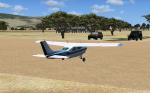
FSX FLRZ Royal Airstrip, Lower Zambezi National Park, Zambia. Addition to FSX, No stock airstrip in FSX. For those who like bush flying
Posted Jun 9, 2012 11:32 by Bashir Ismail
57.13Mb (1859 downloads)
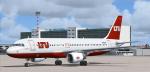
Project Airbus LTU A320 D-ALTB for FSX.
Includes default VC, upgraded by Jim Fly and great custom Airbus A320 sounds.
Posted Jun 9, 2012 06:16 by Jim Fly
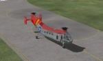
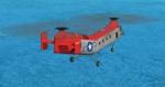
0.10Mb (1523 downloads)
Reworked and new views ( defined by camera definitions in the aircraft.cfg file )
for the beautiful Piasecki H-21C. Original model and upgrade by Mick Posch.
6 cameras pointing at the aircraft and a total of 8 views in the 3D cockpit.
See Read me.txt file for very easy installation procedures.
One camera definitions.txt file for all models
And finally two more files - Available.pdf and Top 20.pdf for informations
about my "camera definitions" packages.
Required files:
required file
Posted Jun 8, 2012 23:55 by Marc Renaud
0.43Mb (237 downloads)
JUST SUBSTITUDE THE A340 2d PANEL INCLUDED IN THE PACKAGE WITH THIS ONE.
IT HAS A MORE REALISTIC SIZED AUTO BRAKES BUTTONS AND THE BRAKES SELECTOR GAUGE HAS BEEN SET FOR THIS FILE ANYWAY.
APOLOGIES FOR THE INCONVINIENCE.
Posted Jun 8, 2012 20:49 by Dimitrios Moschos
6.09Mb (2278 downloads)
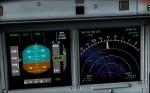
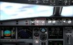
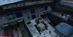
This is v2 of the payware Overland SMS gauges upgrade pack.
It fixes several problems found on the first package and adds a few more features.
NEW FEATURES
1. It adds TERRAIN ON ND function, i.e. you can see the map at the ND (see screenshots). It is not very realistic, compered to the
real thing, however it does add more realism and eliminates the use of the GPS for ground reference.
2. It adds a complete ILS CAT II & III autoland function to the aircraft. The original file belongs to Stefan Liebe, being modified by Francois
Dore, and finally being fine tuned for use with SMS A330 and A340 by me. It has been tested many times and this is the closest it can get
to the real thing. Now you can have a completely zero visibility landing performed automatically.
3. It provides new style square monitor 2d panels.
Posted Jun 8, 2012 20:48 by Dimitrios Moschos
30.50Mb (1151 downloads)
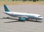
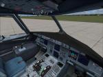
Project Airbus Turkuaz Airlines A320
TC-TCC for FSX.
Includes upgraded default VC by Jim Fly and great custom Airbus sounds.
You can find this aircraft under 'Project Airbus' in your FSX menu.
Posted Jun 8, 2012 06:33 by Jim Fly

56.40Mb (5369 downloads)
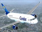
Project Airbus Condor A320 D-AICC for FSX. Includes VC (default) and great custom Airbus A320 sounds. You can find this aircraft under 'Project Airbus' in your FSX menu.
Posted Jun 7, 2012 19:21 by Jim Fly
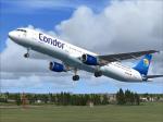
56.71Mb (7243 downloads)
Project Airbus Condor A321 for FSX. Includes VC (default) and great custom Airbus A320 sounds. You can find this aircraft under 'Project Airbus' in your FSX menu.
Posted Jun 7, 2012 18:12 by Jim Fly