


FSX > Page 1260
2.19Mb (1861 downloads)
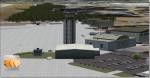
Dobbins Air Force Base is located in Marietta, GA, United States and is home to a Lockheed-Martin F-22 and C-130 factory. When I saw how many people had downloaded my last version I knew I had to make it better and more detailed. The scenery was created with Airport Design Editor (ADE) and Abacus's Scenery Shortcut program. This is only my second scenery build uploaded to the web and I would like to dedicate this to all our American service men and women; now and throughout history!
Posted Jun 7, 2012 04:55 by Joshua Keaton
64.77Mb (2464 downloads)
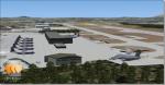
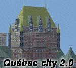
Quebec city version 2.00 for Flight Simulator X.
Quebec city is the capital of the Canadian province of Quebec. Founded in 1608, it's the oldest city in North America. This highly detailed scenery include more than 135 custom buildings built during the past 3 years. Come and see what Quebec City looks likes with it's majors landmarks in your flight simulator. Many new FSX features have been used to build this great scenery like animations and custom special effects. Also, see the CYQB airport scenery by Gilles Boily then enjoy flying in Quebec City.
Posted Jun 6, 2012 11:11 by uploader
0.24Mb (1015 downloads)
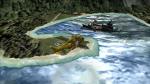
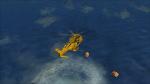
I have made a scenery set up in the Shetland Islands, Scotland, where a fishing boat has ran aground on the north side of the island Foula with two survivors washed up but there are more survivors adrift to
the north east in two orange life rafts and need to be found. Inside the zip file are more instructions and a map to help you find the liferafts.
This is a freeware scenery so it stays that way, the objects are from FSX and FSX Acceleration.
Posted Jun 6, 2012 09:44 by petejg5
57.28Mb (9349 downloads)
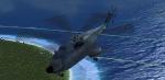
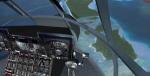
FSX/FS2004 Sud Aviation Super Frelon SA321 heavy transport helicopter Package. Full detailed package with doors, virtual cockpit, autohover, checklist and more! By Benoit Dube, Jean-Pierre Langer, Pierre Marchadier, Baptiste Aubertel / Gmax Academy.
Small edits to the FS2004 version to aid the FSX user.
Danny Garnier.
Posted Jun 6, 2012 09:41 by Garnier D
1.87Mb (1032 downloads)
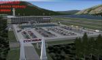
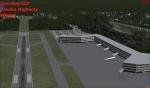
This fictional airport is located on the Donjek River along side of an Alaska Highway. I added a few roads so if you have a vehicle in fsx take a drive.
Posted Jun 6, 2012 00:47 by Coosbay323
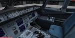
25.79Mb (2194 downloads)
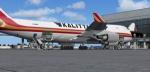
Project Opensky - Boeing 747-4HQF (ER) Kalitta Air for fsx. Kalitta Air is an American
cargo airline headquartered in Ypsilanti Township, Michigan, United States. It operates
international scheduled and ad-hoc cargo.
FSX native model features recolored default 747 VC, Ground services. Posky utilities to
enable ground service traffic and stairs. (Find it under Views-Instrument panel - Posky
Utilities). Textures by Mathieu Vos. Upgraded to FSX model by Chris Evans.
Posted Jun 5, 2012 12:30 by Chris Evans
20.21Mb (4321 downloads)
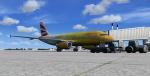
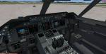
Project Airbus A319-131 British Airways - The Firefly Olympics Livery with VC
This is British Airways Airbus A319-131 in the Special Olympic Games Colors The Firefly with semi photoreal parts (doors, windows, signs) in 32bit format, dirt version ;)
Model by Project Airbus.
High quality textures by Mathieu Vos
Modified for FSX by Chris Evans.
Posted Jun 5, 2012 11:00 by Chris Evans
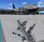
20.26Mb (5107 downloads)
United Boeing 747-400 v4 for FSX
FSX native model features recolored default 747 VC, jetway enabled (Ctrl j), Ground
services. Posky utilities to enable ground service traffic and stairs. (Find it under
Views-Instrument panel - Posky Utilities). High quality textures by Keven Yang.
Upgraded to FSX model with edits by Chris Evans.
Posted Jun 5, 2012 10:33 by Chris Evans
0.00Mb (606 downloads)
The plot is a pilot and his friend have taken off from in a piper cub
Walney Island (EGNL) on the way to Carlisle (EGNC) in the UK.
However on route he collided with an army helicopter between Lake Windermre and Lake Thirlmere,
the helicopter was able to fly south and landed safely with some army soldiers on a training exercise.
Our friend was able to fly north for a little longer before crash landing,
some kayakers on Lake Thirlmere have reported to have seen a plane diving towards the ground
to the south of them.
We believe the pilot is alive but is friend could be injured.
We have also heard reports that a farmer in the area is very angry after some pilots disturbed him
and his sheep.
Find our friend before the army lock him up or worse the farmer does.
Posted Jun 5, 2012 09:38 by petejg5
22.84Mb (958 downloads)
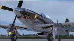
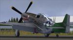
P-51D-25-NA, 44-72671, 2nd Lt. William Saks, 457th FS, 506th FG, North Field, Iwo Jima, June 1945 This is an updated texture using Martin's latest repaint kit found on the A2A forum. This repaint includes both low and high shine versions. Please read the readme.txt file for installation instructions. This upload has resolved the blurry textures at low resolutions.
Posted Jun 5, 2012 09:12 by Wallydog