


FSX > Page 1261
1.15Mb (1442 downloads)
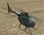
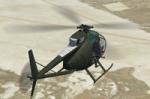
Views ( defined by camera definitions in the aircraft.cfg file )
for the beautiful Hughes OH-6 Loach. Original model by Tim Conrad Piglet.
10 cameras pointing at the aircraft and a total of 3 views in the 3D cockpit.
See Read me.txt file for very easy installation procedures.
One camera definitions.txt file for all models
And finally two more files - Available.pdf and Top 20.pdf for informations
about my "camera definitions" packages.
Required files:
required file
Posted Jun 2, 2012 16:50 by Marc Renaud
159.78Mb (412 downloads)
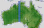
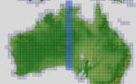
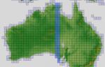
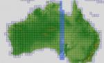
There are Nineteen (19) parts to download for GDEMv2 of Australia.
ASTER GDEM Version 2 is a 30 metre definition DEM, its better than the version 1 data that ERSDAC, of Japan and NASA originally released, but it does have its limitations.
GDEM has been obtained from a satellite that uses stereoscopic infrared scanning cameras, this brings with it problems in the resultant data.....where it sees the tops of trees, buildings etc, as the ground terrain.
If you look at the jpg image with the terrain type errors shown as a graph, you will see that the only 'safe' terrain to use this data with - in FSX - is scrubland, or desert terrain.
Its hopeless in defining the terrain in places like Europe - with all the artificial structures, (buildings) and different types of woodland, so any mesh I create from this data won't include areas like that....it will be more desert type terrain, and scrubland.
I won't be doing Greenland because something about the ice around Greenland, (or any other land mass with ice) it creates false data.
It does give enough fine data to reveal railway lines, and some roads though.
This mesh has been made for FSX only.
Grateful thanks to ERSDAC, and NASA for making this data freely available to the public.
ASTER GDEM
Copyright (c) 2009 - 2011 Earth Remote Sensing Data Analysis Center (ERSDAC) All rights reserved.
ASTER GDEM is a product of METI and NASA.
Posted Jun 2, 2012 04:48 by Wayne Evans
167.82Mb (412 downloads)
There are Nineteen (19) parts to download for GDEMv2 of Australia.
ASTER GDEM Version 2 is a 30 metre definition DEM, its better than the version 1 data that ERSDAC, of Japan and NASA originally released, but it does have its limitations.
GDEM has been obtained from a satellite that uses stereoscopic infrared scanning cameras, this brings with it problems in the resultant data.....where it sees the tops of trees, buildings etc, as the ground terrain.
If you look at the jpg image with the terrain type errors shown as a graph, you will see that the only 'safe' terrain to use this data with - in FSX - is scrubland, or desert terrain.
Its hopeless in defining the terrain in places like Europe - with all the artificial structures, (buildings) and different types of woodland, so any mesh I create from this data won't include areas like that....it will be more desert type terrain, and scrubland.
I won't be doing Greenland because something about the ice around Greenland, (or any other land mass with ice) it creates false data.
It does give enough fine data to reveal railway lines, and some roads though.
This mesh has been made for FSX only.
Grateful thanks to ERSDAC, and NASA for making this data freely available to the public.
ASTER GDEM
Copyright (c) 2009 - 2011 Earth Remote Sensing Data Analysis Center (ERSDAC) All rights reserved.
ASTER GDEM is a product of METI and NASA.
Posted Jun 2, 2012 04:17 by Wayne Evans
227.26Mb (3786 downloads)
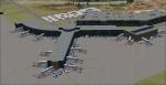
This airport was made using Airport Design Editor, Google Sketchup, and Instant Scenery 2. Albany International Airport, Is an airport located near Albany, New York. The airport has scheduled airline flights. Almost all of the buildings are custom made with photo textures to make it closer to real life. At the main terminal, I added more gates and put moving jetways. The gates have assigned parking codes. There is a parking lot next to the terminal full of cars. I put the airport access road in between the parking lot and the terminal. At the southwest ramp, I put hangars and some you can taxi inside of. If you choose to start off from the southwest DOCK gate, You will start off inside the Million Air Aviation FBO. I also put static aircraft on the ramp too. To the northwest, I put the New York Police hangar. You can start off inside this hangar by choosing the Northwest DOCK gate. Taxiing into or starting off inside a hangar will not cause a crash unless you touch the sides. To the Northeast, I put the cargo terminal with trucks. At the cargo section, I put three FedEx Cessna Caravans. I also put the control tower and the buildings. Tower views are from the roof of the control tower. To the southeast, I put small hangars and the Air National Guard Section with UH-60 helicopters. I extended runway 1/19 to the correct length of 8,500 feet. I also put red, blue, green, and purple Cessna 172s in different places around the airport. There will be more objects if your scenery complexity is set to normal (such as jetways, aircraft, and vehicles). This was all made based on Google Earth Imagery and Bing Maps. There are no night textures for the buildings. This will be added in a future version. An installer program is included to install the airport for you. There will be more versions of this that include night textures and static business jets. This is for Flight Simulator X only. By Tyler Lawrence.
Posted Jun 2, 2012 03:59 by Tyler Lawrence
181.73Mb (409 downloads)
There are Nineteen (19) parts to download for GDEMv2 of Australia.
ASTER GDEM Version 2 is a 30 metre definition DEM, its better than the version 1 data that ERSDAC, of Japan and NASA originally released, but it does have its limitations.
GDEM has been obtained from a satellite that uses stereoscopic infrared scanning cameras, this brings with it problems in the resultant data.....where it sees the tops of trees, buildings etc, as the ground terrain.
If you look at the jpg image with the terrain type errors shown as a graph, you will see that the only 'safe' terrain to use this data with - in FSX - is scrubland, or desert terrain.
Its hopeless in defining the terrain in places like Europe - with all the artificial structures, (buildings) and different types of woodland, so any mesh I create from this data won't include areas like that....it will be more desert type terrain, and scrubland.
I won't be doing Greenland because something about the ice around Greenland, (or any other land mass with ice) it creates false data.
It does give enough fine data to reveal railway lines, and some roads though.
This mesh has been made for FSX only.
Grateful thanks to ERSDAC, and NASA for making this data freely available to the public.
ASTER GDEM
Copyright (c) 2009 - 2011 Earth Remote Sensing Data Analysis Center (ERSDAC) All rights reserved.
ASTER GDEM is a product of METI and NASA.
Posted Jun 2, 2012 03:45 by Wayne Evans
0.09Mb (364 downloads)
Just a small scenery to go with one of the free airports you get with the free
demo from UK2000 VFR airports 1. It adds two rings of fire and two barns you can fly through.
Credits go to UK2000 for making the Old Sarum scenery (if you have it)
and microsoft for the objects. This is freeware so it stays that way.
Posted Jun 2, 2012 03:34 by petejg5
161.76Mb (411 downloads)
There are Nineteen (19) parts to download for GDEMv2 of Australia.
ASTER GDEM Version 2 is a 30 metre definition DEM, its better than the version 1 data that ERSDAC, of Japan and NASA originally released, but it does have its limitations.
GDEM has been obtained from a satellite that uses stereoscopic infrared scanning cameras, this brings with it problems in the resultant data.....where it sees the tops of trees, buildings etc, as the ground terrain.
If you look at the jpg image with the terrain type errors shown as a graph, you will see that the only 'safe' terrain to use this data with - in FSX - is scrubland, or desert terrain.
Its hopeless in defining the terrain in places like Europe - with all the artificial structures, (buildings) and different types of woodland, so any mesh I create from this data won't include areas like that....it will be more desert type terrain, and scrubland.
I won't be doing Greenland because something about the ice around Greenland, (or any other land mass with ice) it creates false data.
It does give enough fine data to reveal railway lines, and some roads though.
This mesh has been made for FSX only.
Grateful thanks to ERSDAC, and NASA for making this data freely available to the public.
ASTER GDEM
Copyright (c) 2009 - 2011 Earth Remote Sensing Data Analysis Center (ERSDAC) All rights reserved.
ASTER GDEM is a product of METI and NASA.
Posted Jun 2, 2012 02:58 by Wayne Evans
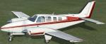
1.59Mb (616 downloads)
All of my FSX default Beech B58 Barons have always worked fine
except for one. The white one with red stripes (as shown in
the enclosed screenshot) has always had black tires while standing
still on the ground, then the tires change to completely white while
rolling on the ground, then they change back to their proper black once
airborn. If this also happens to you while flying your white and red
striped default Baron, this fix may work for you. Easy installation.
By Tom Tiedman
Posted Jun 1, 2012 18:58 by Tom Tiedman
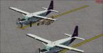
1.81Mb (431 downloads)
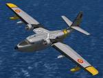
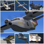
This represents an aircraft assigned to Spanish Air Rescue's Service (SAR: Servicio Aéreo de Rescate), a part of spanish Air Army. Textures only for the payware Aphasim HU-16 Albatross.
Posted Jun 1, 2012 16:48 by Enrique Medal
2.85Mb (5551 downloads)
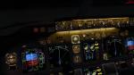
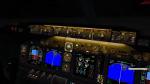
Changes the default blue of the B737-800 gauges to black. Fixes the backup ADf-VOR and changes the Autopilot and speed brake light colours,(reasons for change in colour back to green = the red lights that were created, didn't fit the Panel correctly) same with speed brake
Posted Jun 1, 2012 12:13 by Fabian Irimiea